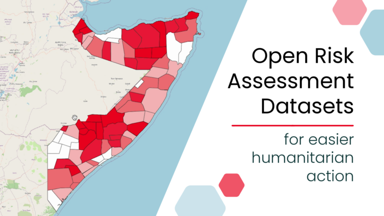
In the face of growing humanitarian challenges, geoinformation plays a vital role in enhancing crisis response, supporting environmental sustainability, and building community resilience. By leveraging data and digital technologies, we assist humanitarian organizations in identifying vulnerabilities and hazards through risk assessments, integrating local knowledge to ensure context-specific and inclusive solutions. Through geospatial expertise, we aim to deliver faster, smarter, and more effective humanitarian responses.
Anticipatory Action (AA) is an innovative strategy that shifts the focus from reactive to proactive measures in humanitarian aid.
AA uses weather forecasts and risk analyses to trigger predefined actions before an event occurs. By integrating scientific data and forecasts into the decision-making process, AA ensures that resources are allocated efficiently and that the most appropriate actions are taken well before a disaster occurs.

We support AA projects globally by offering technical expertise. Our team employs state-of-the-art methodologies and technologies to enhance local data collection, historical impact analysis, risk assessment, and the development of effective triggers for action.
We prioritize collaborative knowledge transfer and training to ensure partners can sustain AA projects long-term. Key to this is creating user-friendly workflows, tools, and services that are accessible to non-technical communities, fostering a shared understanding of local conditions.
We simplify mapping with OpenStreetMap with our tools:

Simplify Data Collection: Our tools simplify complex data processing tasks. They align with open-source frameworks to support humanitarian organizations in vulnerability assessments and Early Action Protocols development.
Apply Advanced Techniques: By incorporating machine learning, we further improve the mapping process and enhance datasets that support humanitarian organizations.
We provide an intuitive, simple tool for participatory in-field sketch mapping through the offline collection, digitization and georeferencing of local spatial knowledge. The tool enables community mapping for disaster preparedness, urban planning, environmental monitoring.
In humanitarian operations, effective mapping and risk assessment are essential for improving decision-making and identifying vulnerable populations. By integrating AI, including machine learning and deep learning, with geospatial data, we can bridge these gaps. This fusion of technologies enables a more comprehensive understanding of disaster preparedness, response, and resilience-building efforts.
As natural disasters become more frequent and intense due to climate change, machine learning helps identify the most vulnerable areas. By analyzing satellite images and environmental data, ML models can assess infrastructure and environmental indicators, like roof types and land permeability, to classify at-risk populations. This allows for more targeted responses and efficient resource allocation.
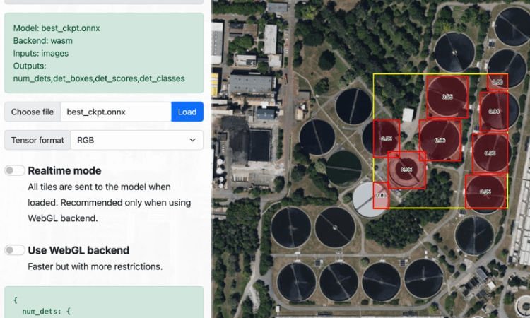
Access to clean water is essential for human well-being, climate action, and sustainable development, yet millions lack it. GeoAI uses machine learning and multimodal sensing data to improve understanding of wastewater treatment plants (WWTPs) and water management. This technology helps fill data gaps, supporting better infrastructure planning and resource management in regions facing water scarcity.

In 2023, a shared vision emerged to make geospatial skills…

Numbers alone do not show whether a child can reach…

The Sketch Map Tool was strategically used within Colombia’s National…