In 2020, the Humanitarian OpenStreetmap Team (HOT) was selected for The Audacious Project, a collaborative philanthropic initiative that serves as a springboard for social impact on a grand scale. This allows HOT to expand its activities and scale up support to local OpenStreetMap (OSM) mapping communities in 94 countries at high risk of disasters or experiencing multidimensional poverty.
HeiGIT and HOT have partnered and extended the Humanitarian OSM Stats website to help relay mapping statistics to the public. It includes data, not only from HOT Tasking Manager projects, but also from all the other OSM contributors by using the ohsome OSM History Data Analytics Platform developed by HeiGIT. This extended Humanitarian OSM Stats website will help HOT monitor progress toward reaching their audacious goals. The website covers 94 countries and 4 regions defined by HOT and provides monthly data. As such, it is an excellent source of statistics and numbers about mapping in OpenStreetMap (OSM) for humanitarian purposes and a great tool to inform wider strategic decision making and team activities. In addition, it can be used by local OpenStreetMap (OSM) communities to check mapping in their countries.
For each region or country you can explore the information through interactive maps and plots.
There are three main categories to be aware of:
- Population mapped
- Mappers
- Local knowledge
Population Mapped
Population mapped describes the number of people living in an area where buildings and roads have been mapped and validated through HOT’s Tasking Manager. Monitoring the mapped population helps to determine the overall progress of mapping in this area and how future mapping tasks may be distributed geographically.
Obtaining knowledge about how populated an area is can be essential for humanitarian organizations to determine what kind of help and how much help is needed in case of a humanitarian disaster. For example, more densely populated areas might require different tools and experts than rural areas.
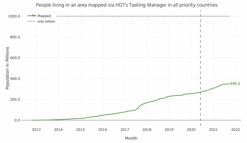
The graph above shows the population numbers living in the area mapped in all regions, currently closing in on 350 million people. This number is continuously growing as more and more contributions help to increase the population numbers living in the area mapped.
Map Editors
Mappers, on the other hand, display the number of people who have made an edit to OpenStreetMap in general and to OSM via HOT’s Tasking Manager. Knowledge about the contributors’ mapping activities is important for HOT to further enhance and define the Tasking Manager and can give information about the characteristics of mapping activities.
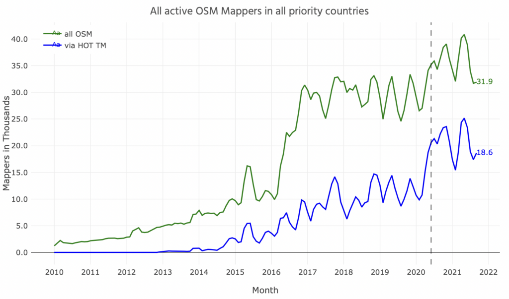
For example, there is a tendency that shows the mapping activity is decreasing at the beginning of each year since 2015, in comparison to the end of the year before. This trend increases from 2019 onwards. There also seem to be “summer-lows” in mapping activity, as visible from 2017 onwards.
Local Knowledge
Finally, Local Knowledge in this case includes the number of villages, cities, and neighborhood names added within a given country or region, as well as the number of facilities added to that area, aggregated by the specific facility.
This can be used to form a basic understanding of the access the given area has to healthcare and other important amenities and how many and what kinds of places, e.g. cities or settlements, are there.
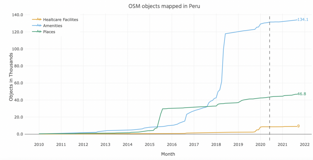
In the case of Peru one can observe stable growth in the number of major roads mapped and rapid growth in the number of buildings mapped from the end of 2015 until today. Interestingly, there are growth spurts at different times for each related tag. This indicates that the mapping activity for Peru is context specific and the increase of mapped objects may differ from the overall mapping activities.
Follow Up and Get Involved
Check out the website here: https://humstats.heigit.org/hot-audacious.html
Get involved: https://tasks.hotosm.org/
Contact at HeiGIT:
Benjamin Herfort
HeiGIT gGmbH
Berliner Strasse 45
69120 Heidelberg
E-Mail: benjamin.herfort@heigit.org
or check the HeiGIT Website: https://heigit.org/contact/
Contact at HOT:
Liz Chamberlain
E-Mail: liz.chamberlain@hotosm.org
This website relies on information from OpenStreetMap (OSM) that has been processed using the ohsome OSM History Data Analytics Platform developed by HeiGIT. The aim of the ohsome framework is to make OpenStreetMap’s full-history data more easily accessible for various kinds of OSM data analytics tasks, such as data quality analysis, on a regional, country-wide, or global scale.
Related research work:
- Herfort, B., Lautenbach, S., Porto de Albuquerque, J., Anderson, J., Zipf, A. (2021): The evolution of humanitarian mapping within the OpenStreetMap community. Scientific Reports 11, 3037 (2021). DOI: 10.1038/s41598-021-82404-z
- Schott, M., Grinberger, A.Y., Lautenbach, S., Zipf, A. (2021): The Impact of Community Happenings in OpenStreetMap — Establishing a Framework for Online Community Member Activity Analyses. ISPRS Int. J. Geo-Inf. 2021, 10, 164. https://doi.org/10.3390/ijgi10030164
- Scholz, S., Knight, P., Eckle, M., Marx, S., Zipf, A. (2018): Volunteered Geographic Information for Disaster Risk Reduction: The Missing Maps Approach and Its Potential within the Red Cross and Red Crescent Movement. Remote Sens., 10(8), 1239, doi: 10.3390/rs10081239.
- Porto de Albuquerque, J., B. Herfort, M. Eckle (2016): The Tasks of the Crowd: A Typology of Tasks in Geographic Information Crowdsourcing and a Case Study in Humanitarian Mapping. Remote Sensing. 2016, 8(10), 859; doi:10.3390/rs8100859.

