In June 2025, researchers from the Urban Big Data Centre (UBDC) and HeiGIT (Heidelberg Institute for Geoinformation Technology) carried out a joint field trip to Colombia to strengthen participatory mapping collaborations. The visit included workshops, partner meetings, and field activities with communities, universities, and government institutions, with a focus on the use and development of the Sketch Map Tool and the Waterproofing Data approach. This on-the-ground engagement is key to deepening partnerships, adapting approaches to local needs, and shaping future collaborative work on participatory mapping in Latin America.
Growing partnerships to strengthen participatory mapping and disaster risk governance in Colombia
Participatory mapping is gaining momentum in Colombia—not just in communities and classrooms, but also at the highest levels of disaster risk governance. This process has been boosted by tools like the Sketch Map Tool, which allows to easily digitize hand-drawn maps, and community-based approaches for data collection like the Waterproofing Data Project.
HeiGIT has been working with the Colombian Red Cross since 2023. With the collaboration of UBDC, this joint work was then expanded to the Colombian disaster risk management authority Unidad Nacional para la Gestión del Riesgo de Desastres (UNGRD). This growing engagement reflects a broader recognition: that local knowledge and geospatial co-production are critical to building resilient, community-informed responses to disasters.
The adoption of digital tools like the Sketch Map Tool, initially used in EVCA processes by the Red Cross and now integrated by UNGRD’s directorate for risk knowledge into the initiative Mapas Comunitarios (“community maps”), signals a shift toward institutionalized participatory approaches in national risk planning.
These developments are further bolstered by a collaboration between HeiGIT and the Urban Big Data Centre (UBDC) through the Waterproofing Data project, which has chosen Colombia as the first country to expand the project after its implementation in Brazil. The project introduces participatory rainfall monitoring and data literacy practices previously developed in Brazil, now being piloted in Bogotá, Cali, and Manizales.
Research visits and on-the-ground collaborations for real local impact
A joint field visit in July 2024 provided an opportunity for HeiGIT and UBDC to support UNGRD’s directorate for risk knowledge in embedding the Sketch Map Tool into their „Mapas Comunitarios“ workflow, aligning local mapping with national policy frameworks. Additionally, the collaboration with the Colombian Red Cross deepened the implementation of the Sketch Map Tool in the context of Enhanced Vulnerability and Capacity Assessments throughout Colombia, including follow-ups on training, data use, and institutional embedding.
At the same time, Waterproofing Data pilot projects advanced in initial agreements with authorities in Bogotá, Cali and Manzinales as part of a collaboration between UBDC and UNGRD. The local disaster risk management teams and city administrations expressed their interest in monitoring rainfall and water-related impacts with schools and communities, adapting the methodological approach developed in Brazil and Burundi.
The visit was also a prime occasion to strengthen research collaboration with the Universidad de La Guajira and the Universidad Distrital Francisco José de Caldas in Bogotá, delivering a participatory mapping course as well as a public lecture in which Anne Schauss (HeiGIT) and Diego Pajarito Grajales (UBDC) shared various case studies with students and researchers. Meeting with national and academic institutions (OPIAC (National Organization of Indigenous Peoples of the Colombian Amazon), Ministry of Housing, and Javeriana University, among others) was key to exploring shared topics of interest and discussing how to scale up participatory mapping efforts in the future.
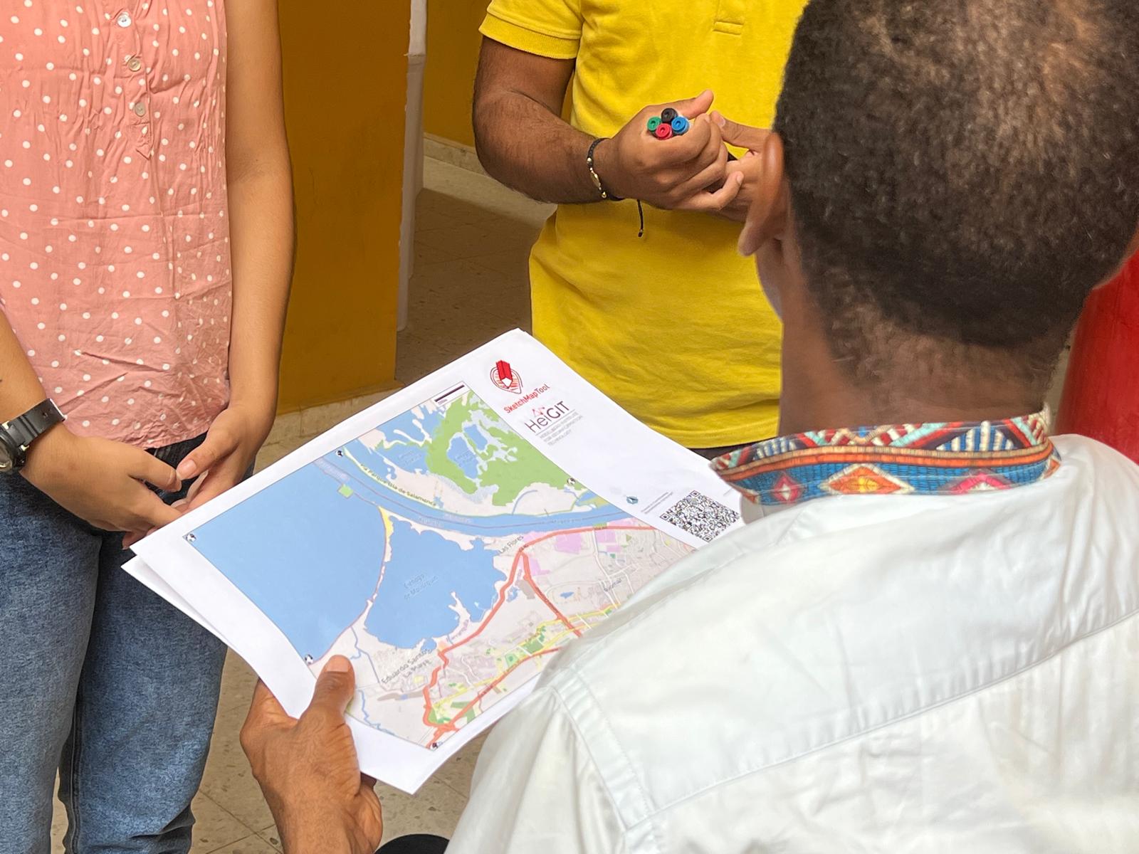
Participatory Mapping with the Sketch Map Tool
The main part of the fieldwork involved the School of Engineering at the University of La Guajira, which hosted a course on participatory mapping to boost participation and local data production.
The La Guajira region in Colombia has historically faced social inequalities within a complex environment with wide population diversity and vast amounts of natural resources (e.g., coal, gas, wind and solar). Data and official statistics are still insufficient to ensure fair and just development plans or research projects that meaningfully integrate ancestral and local knowledge, needs and perspectives.
The Environmental Systems Research Group (GISA) at the University of La Guajira has been integrating participatory mapping into its research projects, e.g., for evaluating flood risk management solutions and for monitoring water quality. GISA connected with HeiGIT and UBDC to expand this community-based work with a tailored course on participatory mapping.
Course on Participatory Mapping and Co-Production of Geospatial Data
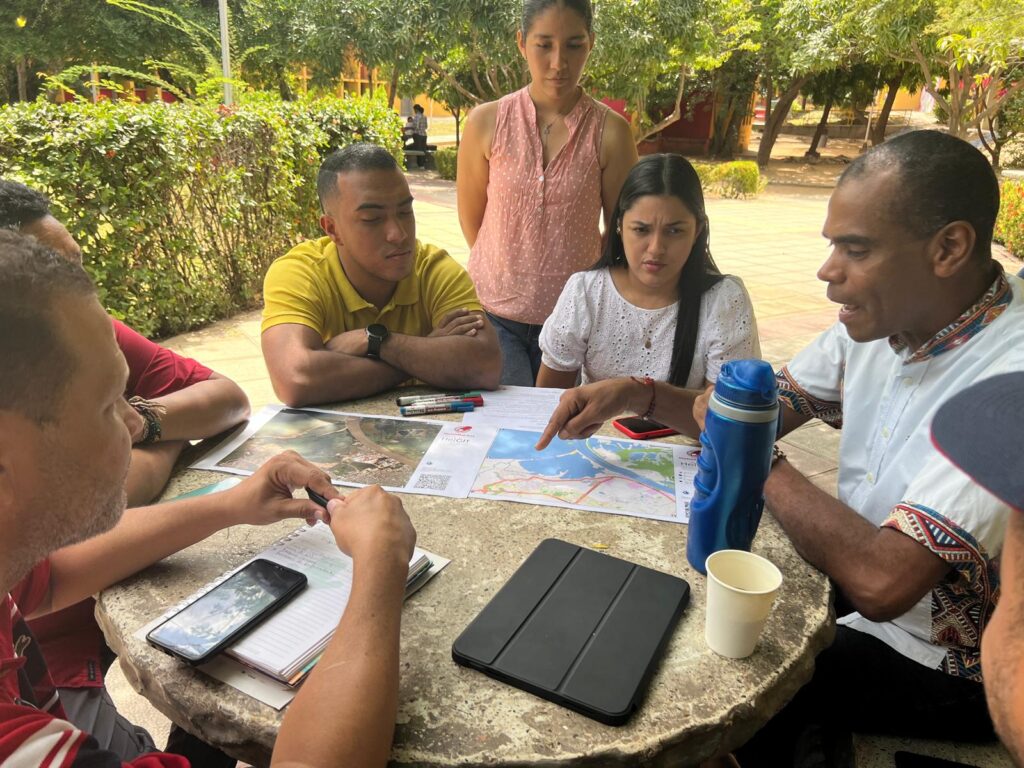
This collaboration resulted in the course „Participatory mapping and co-production of geospatial data with the Sketch map Tool“, jointly designed by UBDC and HeiGIT as an interdisciplinary and intercultural space to exchange ideas around mapping and data co-production. For four days, participants discussed the principles of participatory mapping and related ethical concerns, engaging in practical, in-depth exercises with the Sketch Map Tool and other digital tools that enable participatory mapping. Through the course, participants experienced how the Sketch Map Tool supports all phases of participatory mapping, from discussing the importance of base maps and developing a mapping strategy to carrying out a role-play mapping exercise. They also learned how to align their mapping practices with the tool’s AI component, analyzed the outputs, and explored ways to visualize and further process the data in GIS systems.
The course brought together participants from local government agencies, researchers, university students, and NGOs. It also served to showcase the different mapping efforts carried out in the region (e.g. risk management) through presentations from local leaders. The highly interactive course equipped participants to critically reflect on and apply fair and inclusive participatory approaches in their own projects.
The participants demonstrated strong engagement throughout the course and expressed their interest in adopting Sketch Map tool to enable data co-production within their communities. In addition, participants expressed interest in the environmental monitoring strategy that UBDC is championing through the Waterproofing Data Project.
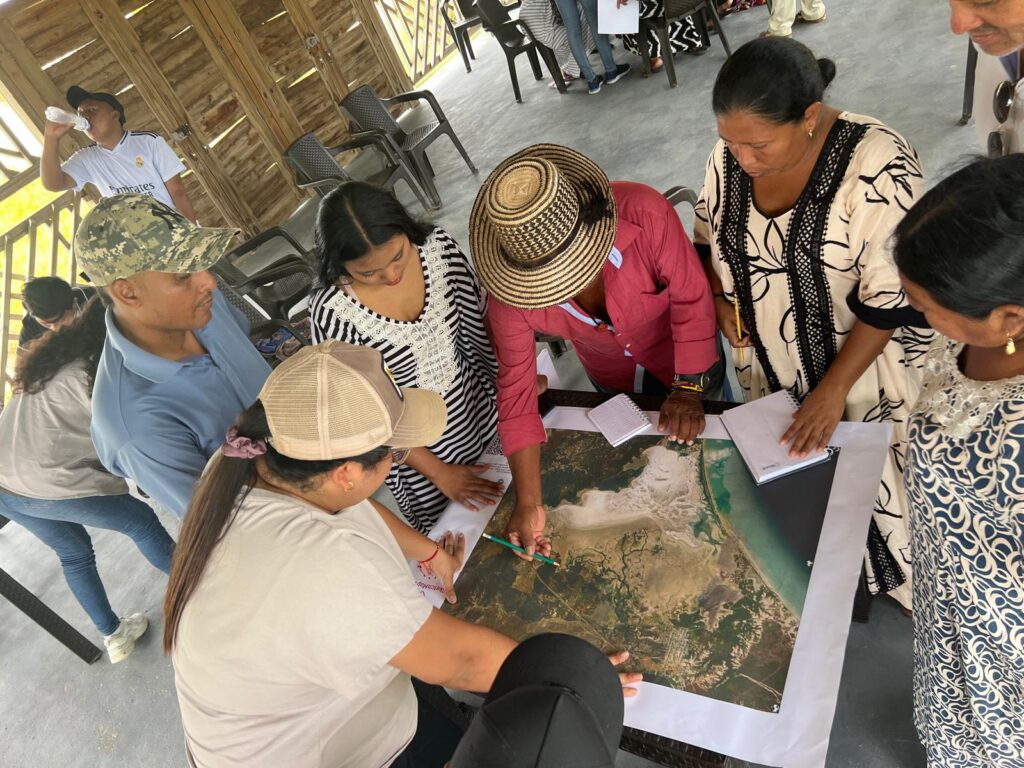
Field Mapping Activity with Wayuu Communities
Part of UBDCs and HeiGIT activities in collaboration with the University of La Guajira consisted of guiding a participatory mapping activity with Wayuu communities, which represent the largest indigenous population in Colombia).
The participatory mapping workshop was carried out in the National Park Los Flamencos as part of the project “Environmental quality assessment of microplastics in the Los Flamencos Fauna and Flora Sanctuary in the District of Riohacha, La Guajira, Colombia”, which aims to increase awareness and develop capacities in local communities to manage micro plastics in the lagoon where they reside. These communities rely heavily on the lagoon’s natural resources for their livelihoods, which are increasingly at risk due to microplastic pollution. In a world-café-like mapping session provided in Spanish and Wayuunaiki, participants from different communities mapped important information on three themes: trash accumulations, clean and contaminated water inflows and fishing areas.
The Future of Participatory Mapping in Colombia and Beyond
Colombia is emerging as a key site where technical innovation, policy interests, and grassroots knowledge converge, making it a promising landscape for shaping the future of participatory geodata practices in Latin America. In a context marked by advances in local governance and peacebuilding, as well as rich geographic, cultural, and ecological diversity, participatory approaches and local data production play a vital role in informing equitable, resilient, and context-sensitive decision-making.
Spending time in Colombia—carrying out workshops, meeting with partners, and engaging with local actors and communities—has been a powerful reminder of how important it is to ground technical tools in real-world needs and experiences. These interactions offered invaluable insights into the local challenges and opportunities around geospatial data co-production while reinforcing the importance of fair, inclusive and culturally grounded approaches.
The collaborative use of the Sketch Map Tool through hands-on exercises, field activities, and in-depth discussions with institutional partners allowed us to critically reflect on its current capabilities and limitations. We are at work to translate these experiences into technical improvements and ensure that the Sketch Map Tool continues to support fair and meaningful participatory mapping. At the same time, discussions around education and the role of students in monitoring their territories and identifying impacts of extreme climate events through strategies like Waterproofing Data opened opportunities to reflect on how to effectively manage disaster risks in urban spaces.
We received encouraging feedback and strong interest from a wide range of actors, confirming the relevance and impact of our participatory approach and the great potential for future collaboration on diverse topics in Colombia. We look forward to the continued collaboration and co-development, as well as new partnerships and future applications ahead.
This blog article has been jointly written by HeiGIT and UBDC.
To learn more about how the Sketch Map Tool works, watch this quick video tutorial or directly visit the project webpage. To stay up to date on new Sketch Map Tool releases and case studies, you can subscribe to the Sketch Map Tool Newsletter.
Questions or ideas on how to next use the Sketch Map Tool? Write us at sketch-map-tool@heigit.org. We are looking forward to getting in touch.


