Our new paper on Machine Learning and Humanitarian Mapping
Nowadays, Machine Learning and Deep Learning approaches are steadily gaining popularity within the humanitarian (mapping) community. New tools such as the ML Enabler or the rapId editor might change the way crowdsourced data is produced in the future. Hence, at the Heidelberg Institute for Geoinformation Technology and the GIScience Research Group we investigated the potential of Deep Learning in combination with MapSwipe’s crowdsourcing approach. Check out our new paper published in the Remote Sensing special issue on citizen science and earth observation:
Herfort, B.; Li, H.; Fendrich, S.; Lautenbach, S.; Zipf, A. Mapping Human Settlements with Higher Accuracy and Less Volunteer Efforts by Combining Crowdsourcing and Deep Learning. Remote Sens. 2019, 11, 1799.
What is the paper about?
Reliable techniques to generate accurate data sets of human built-up areas at national, regional, and global scales are a key factor to monitor the implementation progress of the Sustainable Development Goals as defined by the United Nations. However, the scarce availability of accurate and up-to-date human settlement data remains a major challenge, e.g., for humanitarian organizations.
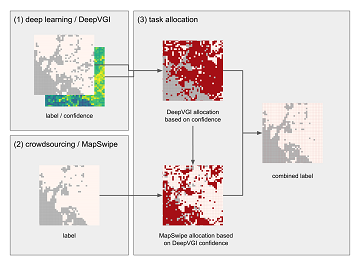
In our recently published paper, we investigated the complementary value of crowdsourcing and deep learning to fill the data gaps of existing earth observation-based (EO) products. To this end, we propose a novel workflow to combine deep learning (DeepVGI) and crowdsourcing (MapSwipe). Our strategy for allocating classification tasks to deep learning or crowdsourcing is based on confidence of the derived binary classification.
Figure 1: Proposed workflow to combine deep learning and crowdsourcing methods
We conducted case studies in three different sites located in Guatemala, Laos, and Malawi to evaluate the proposed workflow. Our study reveals that crowdsourcing and deep learning outperform existing EO-based approaches and products such as the Global Urban Footprint. Compared to a crowdsourcing-only approach, the combination increased the quality (measured by Matthew’s correlation coefficient) of the generated human settlement maps by 3 to 5 percentage points. At the same time, it reduced the volunteer efforts needed by at least 80 percentage points for all study sites.
The study suggests that for the efficient creation of human settlement maps, we should rely on human skills when needed and rely on automated approaches when possible.
Further MapSwipe Development
We are currently working on new project types for MapSwipe. This will also allow us to integrate machine learning results better into our existing crowdsourcing workflows. Sounds Interesting? Check out MapSwipe’s Github repositories or join the MapSwipe working group.

