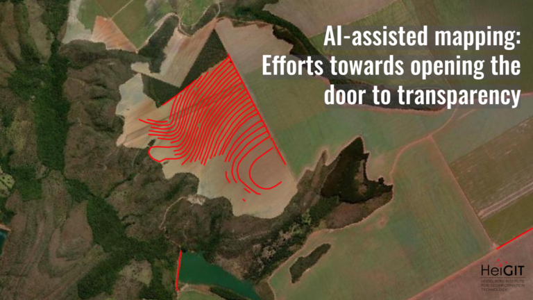
This study examines the resilience of urban infrastructure, with a focus on road network connectivity and redundancy in the face of extreme weather events. Using OpenStreetMap (OSM) data and the openrouteservice (ORS) routing engine, the research assesses centrality metrics and redundancy to evaluate how floods impact mobility and access to critical services, such as healthcare.
As climate change intensifies the frequency and severity of extreme events, assessing the resilience of urban road networks becomes increasingly vital. Ensuring connectivity—particularly to essential services like hospitals—and identifying safe evacuation routes are critical components of effective spatial planning and humanitarian response during disasters such as floods, landslides, and mudslides.
Brazilian cities have experienced numerous flood events in the 21st century, often with devastating impacts. The catastrophic flooding in Rio Grande do Sul on April 29, 2024, is a stark example of how torrential rainfall can cripple urban infrastructure. Events like the one in Porto Alegre highlight the urgent need to understand and strengthen the resilience of urban networks to improve emergency response and protect vulnerable populations.
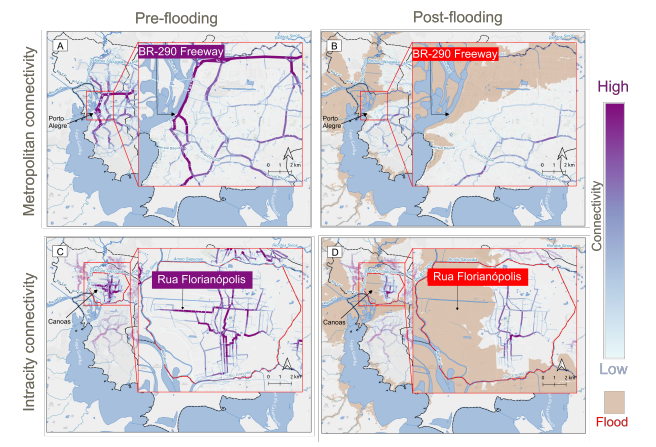
This research investigated the effects of the 2024 flood on road network connectivity in Rio Grande do Sul, with an emphasis on redundancy to healthcare facilities. Redundancy is understood here as the availability of alternative routes, based on the 4R model of resilience (Rözer et al., 2022). Using edge betweenness centrality, the study identifies critical urban arteries and assesses the availability of alternate paths to key healthcare locations across both metropolitan and municipal scales.
To ensure transparency and reproducibility, the study relies open data and methods. Road network data from OSM is used to construct the network graph, while ORS enables routing and centrality analysis, in combination with flood extent and healthcare facility data.
Key findings reveal that just 71 km—or 2% of the total analysed network—accounted for 12% of core-metropolitan connectivity prior to the floods. These high-centrality urban arteries, including the BR-290 Freeway, were disproportionately affected: they lost approximately 92% of their total centrality after the
flooding. Overall, the road network experienced a 59% reduction in betweenness centrality at the core metropolitan scale. At the municipal level, impacts varied. For example, Canoas experienced a 59% loss in intracity connectivity, while Nova Santa lost only 14%, despite a larger flooded area (113 km2 versus 65 km2).
In terms of healthcare access, the analysis revealed that peripheral hospitals, such as Hospital Restinga e Extremo Sul, were particularly affected, highlighting spatial disparities in urban resilience. These results underscore the importance of multiscale assessments to identify localized vulnerabilities and guide targeted interventions.
The study offers actionable insights for policymakers, emphasizing the need to enhance redundancy in high-risk areas, retrofit critical infrastructure, and address inequities in access to essential services. While the methodology is designed for broad applicability, the findings are specific to a single metropolitan context and may not be directly generalizable to regions with different infrastructure or flood characteristics. Nevertheless, by leveraging open data and tools, this approach provides a scalable and transparent framework for resilience analysis in diverse urban settings.
The research was presented at the 28th AGILE Conference on Geographic Information Science, 10–13 June 2025.
Full paper: Sánchez, R. R., Reinmuth, M., Albornoz, C., Lautenbach, S., & Zipf, A. (2024). Changes in road centrality and hospital access redundancy: Impacts of the 2024 flood in the metropolitan core of Porto Alegre, Brazil. AGILE: GIScience Series, 6, 10. https://doi.org/10.5194/agile-giss-6-10-2025
Image description: Changes in the road connectivity identifying roads with high edge betweenness centrality values as urban arteries. The connectivity between all the municipalities (A,B) represents the CM connectivity. In contrast, the maps (C,D) show the intracity connectivity for each individual municipality. The urban artery BR-290 Freeway in Porto Alegre in the post-flooding event, while the urban artery Rua Forianópolis is affected by the flood in the municipality of Canoas