The paper, published in Nature Scientific Data, presents the first high-resolution (10m or finer) land use map of the European Union derived from a large-scale fusion of OpenStreetMap (OSM) and Copernicus Sentinel-2 data. Leveraging citizen-generated data and remote sensing, the authors demonstrate a scalable and globally applicable methodology to fill thematic and spatial gaps in land use and land cover (LULC) information. The result is a validated, open-access product with 89% overall accuracy and extensive policy and environmental monitoring implications.
The paper introduces a novel, high-resolution land use (LU) mapping approach for Europe that combines OpenStreetMap (OSM) and Copernicus Sentinel-2 satellite data. It represents the first successful fusion of these two data sources across such a large geographic area at a spatial resolution of 10 meters or finer. The methodology is not only scalable across Europe but is also designed to be globally transferable.
Human activity has had a significant impact on most of the Earth’s terrestrial surface. Monitoring and understanding these impacts requires reliable, temporally and spatially consistent land use and land cover (LULC) data. Recent advances in remote sensing, artificial intelligence, and open data policies have significantly expanded the potential for creating detailed and consistent LULC products. However, limitations persist—particularly due to the fragmented and thematically inconsistent nature of OSM data, which often leads to incomplete spatial coverage in LULC maps.
To address these gaps, the authors developed a methodology that translates OSM tags into standardized land use labels. These labels were then used to annotate 61.8% of the EU’s territory. Using this labeled data, the team trained a series of country-specific convolutional neural networks on Sentinel-2 imagery (2020 composites at 10m resolution) to predict land use in unlabeled regions. This combination of citizen science and AI-driven remote sensing enabled comprehensive LULC classification across the EU.
The resulting dataset, referred to as OSMlanduse, achieved an overall accuracy of 89%, with class-specific accuracies ranging between 77% and 99%. The paper includes detailed methodology and validation processes, ensuring transparency and reproducibility. All data is openly accessible and available for visualization through the OSM Landuse web portal.
This research was funded by the EU Horizon 2020 LandSense project and represents a significant step forward in the integration of volunteered geographic information and Earth observation data for large-scale environmental monitoring.
Dataset: OpenStreetMap land use for Europe “Research Data“
Visualization: OSM – Landuse
Reference: Schultz, M., Li, H., Wu, Z., Wiell, D., Auer, M., & Alexander, Z. (2025). OSMlanduse a dataset of European Union land use at 10 m resolution derived from OpenStreetMap and Sentinel-2. Scientific Data, 12(1), 750. https://doi.org/10.1038/s41597-025-04703-8
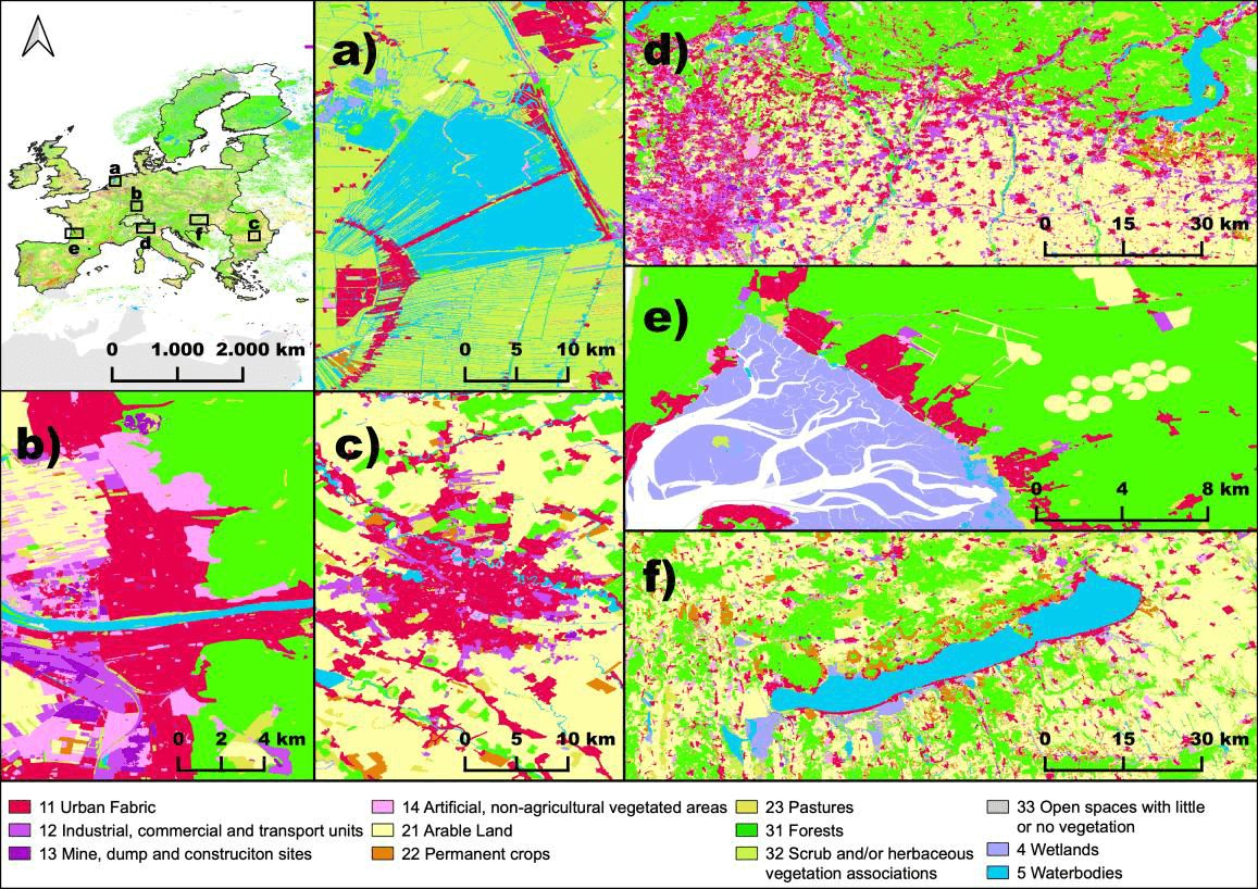
Title Image: Map facets highlighting the OSMlanduse details and suitability for various landscapes a) inland water in Utrecht province, b) city of Heidelberg, c) metropolitan area of Bucharest, d) Po valley and Millan, e) wetlands river estuary, close to Bordeaux f) lake Balaton close to Siófok


