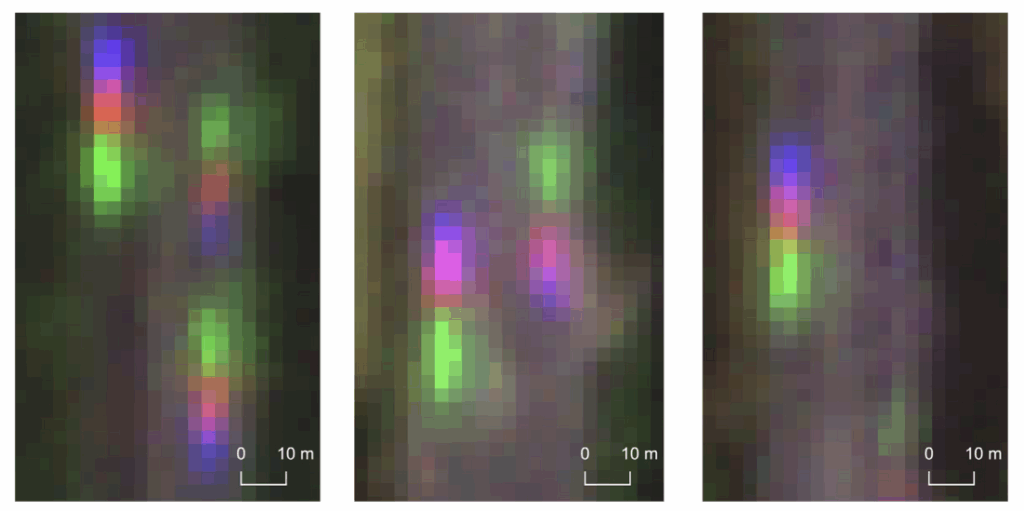
A recent study has demonstrated a novel approach to the large-scale monitoring of road traffic. Rather than relying on radar or mobile sensors, the team used PlanetScope’s Super Dove satellite imagery to detect moving vehicles and estimate their speed.
By implementing a Keypoint R-CNN learning model, the researchers were able to track the subtle “motion echoes” of vehicles across the satellite’s RGB bands. This methodology enabled the identification of individual vehicles on major highways in Germany and Poland and the subsequent estimation of their velocity. The accuracy of these measurements was validated against drone footage and GPS data.
The implementation shows how daily, medium-resolution satellite data can complement traditional traffic monitoring by covering areas that would otherwise require expensive ground infrastructure. In practice, the method can support large-scale studies of traffic patterns, congestion hotspots, or changes in road use. It can be used especially in regions where conventional data is infrequent.
Although high-speed measurements remain a challenge, this proof of concept demonstrates an innovative, scalable tool for global traffic analysis, paving the way for better-informed urban planning and mobility management in the future.
Read the full paper: https://www.sciencedirect.com/science/article/pii/S1569843225003541
Refercence: Adamiak, M., Grinblat, Y., Psotta, J., Fulman, N., Mazumdar, H., Tang, S., & Zipf, A. (2025). Deep learning enhanced road traffic analysis: Scalable vehicle detection and velocity estimation using PlanetScope imagery. International Journal of Applied Earth Observation and Geoinformation, 142, 104707.