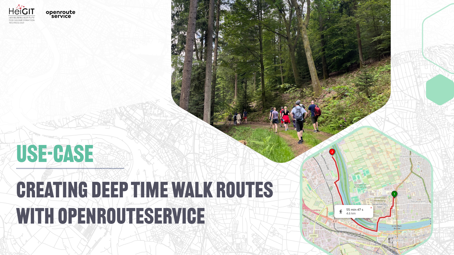
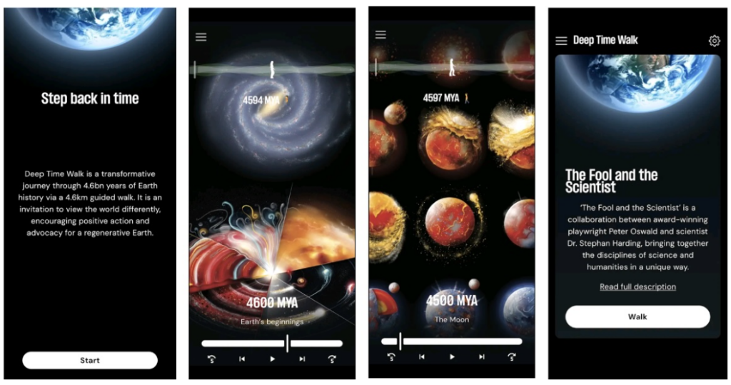
Earth’s 4.6 billion-year history is difficult to comprehend due to its immense timescale. Deep Time Walk brings Earth’s history to life through open geospatial tools and hands-on learning, allowing people to experience it in their communities and take action for a regenerative future. Through its network of facilitators and mobile apps, the experience offers a guided 4.6 km walk through Earth’s deep history. Around 1,000 facilitators now lead walks across six continents, in places ranging from city neighbourhoods to forests and coastal areas. As they design these routes, they place “Earth Stations” at points along the path that correspond to key moments in time across our planet’s evolution.
An Example Walk:
A facilitator leading a walk along the River Dart in Devon, UK, might design something like this:
Before a single step is taken, the group gathers in a riverside meadow. Phones are put away, and together they take one collective jump backwards – a leap through a “time portal” to 4.6 billion years ago, before the Earth had formed. From here, every metre walked is one million years; every stride, roughly 500,000.
- Start – 0.000 km (4,600 MYA, Formation of Earth): A flat meadow by the water. There is nothing underfoot yet – just the dust of an exploded star drawing together into a young Sun and the first molten Earth. The group begins the walk knowing they are, quite literally, made of stardust.
- 0.500 km (4,100 MYA, Ocean Earth): A gentle climb through woodland. Meteorites still hammer the cooling planet, but rain begins to fall – and keeps falling for millions of years – until a single ocean wraps the whole Earth.
- 0.800 km (3,800 MYA, Origin of Life): A pause beside the river to mark the birthday of life. In the deep ocean, maybe near hydrothermal vents, the Last Universal Common Ancestor stirs into being – the single root from which every living thing descends.
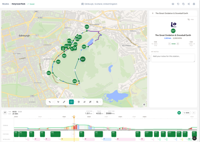
- 2.300 km (2,300 MYA, The Great Oxidation & Snowball Earth): The exact midpoint of the walk – a beat a facilitator can only land on if the route’s total length is truly 4.6 km. Rising oxygen tips the climate into a runaway freeze, and ice spreads from the poles to the equator.
- 4.061 km (539 MYA, The Cambrian Explosion): Crossing a footbridge, the river widening below, as life suddenly erupts into shells, eyes, teeth and the first backbones.
- 4.534 km (66 MYA, Dinosaur Extinction): A steeper climb onto open moorland – a sudden, jolting transition that mirrors the asteroid strike that ends the age of the dinosaurs.
- 4.599 km (1 MYA, Human Evolution): The final metre. Within it, the last 30 cm holds the entire span of Homo sapiens, and the last quarter of a millimetre – barely a fingernail’s edge – covers everything since the Industrial Revolution.
- End – 4.600 km (Present day, then Stepping into our futures): Arriving back in the present, the group looks back over the valley at the deep time laid out behind them – and turns to imagine, together, which future they will walk towards.
Building the Route Creator
A Deep Time Walk is different from a regular walking route. The distance must be exact, since each metre corresponds to a specific moment in Earth’s history. Special spots called “Earth Stations” are placed at specific locations, and the route follows real, walkable paths between those locations in settings like city parks and coastal trails.
To solve this, Deep Time Walk created a Route Creator tool for their facilitator community. This web app lets facilitators design, manage, and share routes in their communities. Facilitators can create routes in three ways: by clicking points on the map, by importing a GPX file, or by freehand tracing with a pencil tool. In all three cases, the coordinates are sent to openrouteservice via a Next.js backend proxy, which returns a snapped walking route along with elevation and surface data. The proxy keeps the API key secure, enables in-session caching for repeated route segments, and provides the frontend with a consistent interface.
The Role of openrouteservice
The tool calls the public openrouteservice API – the free community endpoint – using the Directions service with the foot-walking profile, because Deep Time Walks are slow, reflective journeys, so other profiles aren’t appropriate. Alongside it, the Elevation service supplies height data along the route. Together these return the route geometry, elevation, and surface information that the software then builds on.
While the distance and route are provided by the openrouteservice API, the app adjusts the walking speed using a Tobler-style calculation based on slope and surface data. This helps facilitators to better understand the terrain and have more localised walking times. The app presents route-planning results through an elevation profile and a timeline view, making it easier for the facilitator to understand when each Earth Station will be reached.
Because openrouteservice returns the precise length of every route, the Route Creator can also place each Earth Station automatically at its exact point along the path – the formation of the Moon, the Cambrian Explosion, the dinosaur extinction and the rest each landing at the correct distance from the start. This used to be a painstaking manual process that could take hours of measuring by hand.
These terrain-adjusted timings matter in practice. A Deep Time Walk is designed to run for a minimum of around three to three-and-a-half hours, so realistic estimates help facilitators shape a route that fills that window at a slow, contemplative pace. The same surface and gradient data also let facilitators match a route to a group’s mobility – choosing gentler ground where it’s needed and flagging steep or rough sections before anyone sets off.
Creating Routes with OpenStreetMap
By using OpenSteetMap, the project is able to provide their walks even in areas where most commercial map creators only provide a few or no routes at all. However, even OpenStreetMap data does not always cover every small hiking path. In this case, when a route can’t be matched, it draws a straight dashed line and marks it as unrouted so that planning can continue. The tool still collects elevation data for these parts to keep the profile complete. Facilitators can also turn off snap-to-path and manually add waypoints when the mapped paths do not match what is on the ground.
Because the project is built on OpenStreetMap, this can become a two-way relationship: when facilitators discover a real path that the map is missing, they can contribute it back to OpenStreetMap, improving the data for everyone who relies on it – not only the Deep Time Walk community.
The freehand tracing tool has its own backup. If route matching fails, the application retains the facilitator’s original drawing and returns it instead of deleting it.
With the Route Creator, anyone from a teacher to a forest ranger or community organiser can design a route that fits their local area and supports the wider educational goals of Deep Time Walk. In this way, openrouteservice helps translate distance, terrain, elevation, and movement into a shared experience of planetary time, contributing to a transformative educational experience that connects people to Earth’s history.
Deep Time Walk chose openrouteservice because it is open-source, uses OpenStreetMap data, and aligns with the project’s educational and public-interest values. As a Community Interest Company – a non-profit social enterprise – Deep Time Walk also depends on tools that are free and openly licensed, making a community-supported routing engine not just a good philosophical fit but a practical foundation for the work.
You can find out more about the project via their website (deeptimewalk.org) or their community of facilitators (community.deeptimewalk.org).