The need for responsible GeoAI in climate extreme and disaster mapping
Extreme weather events and disasters are growing more frequent and intense. Climate change and disasters particularly affect the most vulnerable communities, exacerbating the divide between the Global North and the Global South.
Geospatial Artificial Intelligence (GeoAI) has emerged as an important approach for disaster management, rapidly changing the way we map. The development of GeoAI raises a series of issues. Critical voices warn that it can amplify existing inequalities, mislead disaster decision-making, and have a negative environmental impact, worsening the climate-related disasters it is meant to tackle in the first place.
This position paper by Hao Li and Steffen Knoblauch examines the role of GeoAI from a critical perspective and makes the case for more responsible GeoAI, especially in climate extreme and disaster mapping.
Four pillars of responsible GeoAI: representativeness, explainability, sustainability and ethics
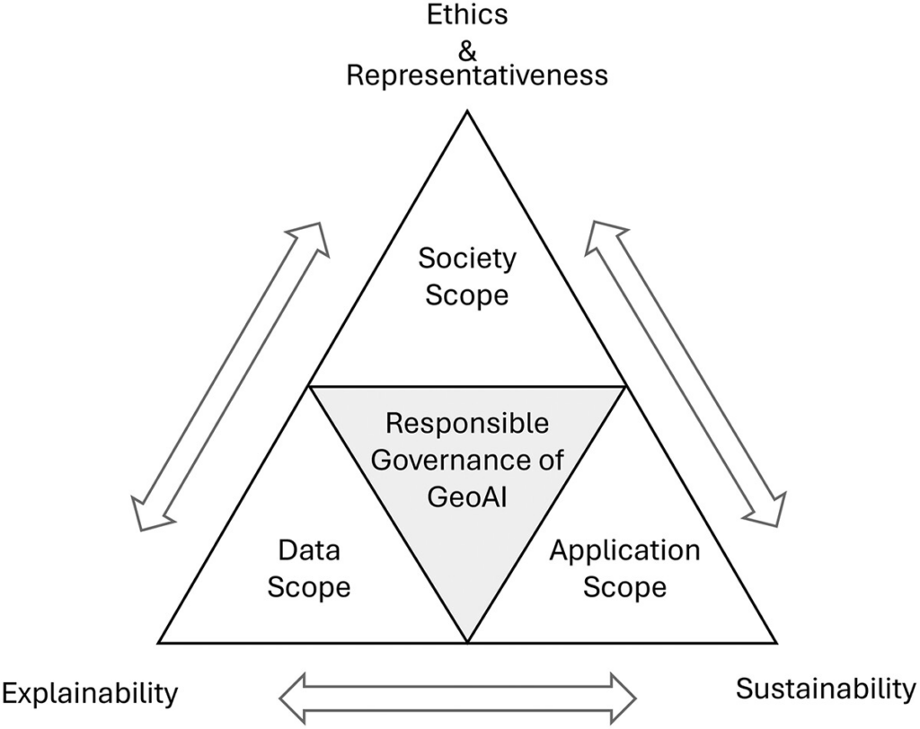
The paper discusses four main dimensions for responsible GeoAI: being representative, explainable, sustainable and ethical. Each of these dimensions is intertwined with the others.
Representativeness
Geographic data often has a strong Global North bias, so vulnerable communities, low-income areas and Indigenous territories are underrepresented on the map, and GeoAI models trained on that data pass the gap on. Models also often fail when they are generalized and transferred to different environments. Representativeness requires keeping humans in the loop, supporting local mapping communities, working to close data gaps, and accounting for local differences.
Explainability
To trust GeoAI, we need to understand how it reasons about space: how a model handles factors like distance, neighborhood relationships and scale. Only then can its predictions support transparent and responsible decisions in disaster management.
Sustainability
Training huge geospatial models uses large amounts of energy and contributes to climate change, worsening the causes behind the disasters they are built to combat. Greener approaches can help break that cycle, e. g. reusing existing models (for example through Retrieval-Augmented Generation) or processing data close to the disaster site instead of in the cloud.
Ethics
Even well-meant disaster mapping can be unethical if it exposes people’s private data or other sensitive information. Moreover, models trained on historical data can raise ethical issues by favoring well-documented, wealthier neighborhoods over marginalized ones. Responsible GeoAI needs privacy safeguards, fair algorithms, respect for data sovereignty and constant human oversight.
How to put responsible GeoAI into practice
The paper proposes a practical framework for using GeoAI reliably and responsibly, including choosing greener, carbon-aware computing. This framework integrates the dimensions of representativeness, explainability, sustainability and ethics with three operational scopes:
- Data: Responsible GeoAI starts with good data practice: clear quality checks, strong privacy protection and consistent metadata. In a post-disaster mapping effort, for example, teams should screen incoming data carefully, protect people’s private information and stop crowdsourced data from privileged, digitally connected neighborhoods from skewing the picture.
- Application: When a model is used during a crisis, there should be a standard workflow for combining data, tracking progress and checking quality. For instance, if a flood-mapping model starts mistaking cloud shadows for flooded areas, it should be clear how the model quickly gets audited, recalibrated or reviewed by human experts.
- Society: Responsibility for decision-making needs to be clearly allocated across the human, community and policy dimensions. Before a disaster hits, it should be settled who controls the data, be it a local emergency agency, a humanitarian NGO or a private company.
Using GeoAI carelessly can deepen spatial inequalities, lead to poor emergency decisions and cause environmental costs that work against global climate goals. The authors argue that better disaster risk reduction will not come from building ever more models, but from a culture where AI supports geographic reasoning and local knowledge. The GIS community plays a key role in embedding responsibility into GeoAI algorithms and operational workflows. If we judge GeoAI by how responsible, ethical and sustainable it is, not only by how well it performs, it can help build a more disaster-resilient future, especially for the Global South.
Reference:
Li, H., & Knoblauch, S. (2026). Unbox responsible GeoAI: navigating climate extreme and disaster mapping. Annals of GIS, 1–12. https://doi.org/10.1080/19475683.2026.2755217