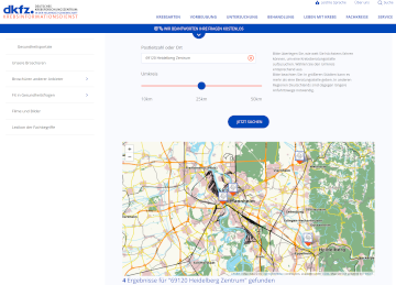
One of HeiGIT’s goals is the beneficial use of geoinformation for society. To this end we provide a range of different Web services, mostly based on OpenStreetMap (OSM), such as…
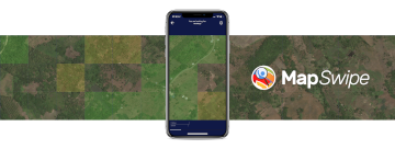
MapSwipe has ben announced as ‘App of the Day‘ in the Apple AppStore! (27.08.2021) Thank you to all our volunteers for the continued help and support which keeps the app…
Die aktuelle Flut in Deutschland hat zahlreiche Straßen in den betroffenen Gebieten zerstört oder temporär unpassierbar gemacht. HeiGIT arbeitet an freien und offenen, auf Geodaten-basierten Lösungen für die humanitäre Hilfe….
Klima-Anpassungsstrategien, die Risikogruppen während Hitzeperioden unterstützen und schützen sollen, werden im Rahmen der transdisziplinären Zusammenarbeit im Projekt HEAL vom Forschungsverbund bestehend aus dem Heidelberg Institute for Geoinformation Technology (HeiGIT), der…
Im Rahmen einer transdisziplinären Zusammenarbeit entwickeln das Heidelberg Institute for Geoinformation Technology (HeiGIT), die GIScience Forschungsgruppe sowie das TdLab Geographie der Universität Heidelberg gemeinsam Anpassungsstrategien, die Risikogruppen während Hitzeperioden unterstützen…
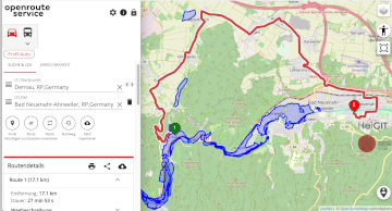
In this blog post we want to take a closer look at a fruitful mapping collaboration between humanitarian organizations and corporations. Since 2015 mapping remote areas in OSM is one…
The AGILE 2021 conference is taking place this week. It is the the 24rd AGILE conference on GIScience. AGILE is the Association of Geographic Information Laboratories in Europe and the…
Dear mappers, on Monday 17.5.2021, 18.00pm a third international mapathon together with disastermappers heidelberg, MAMAPA, CartONG, HuMap and OSM Ghana will take place, which will give you some insights in…
The project “25 Mapathons“ goes into the next phase. Based on the experience of until today 17 OSM mapathons with German Red Cross (GRC) chapter and an extensive literature review…
Die Folgen des Klimawandels sind besonders stark in den höheren Breiten unseres Planeten zu spüren. Die Arktis erwärmt sich derzeit überdurchschnittlich schnell. Dies führt zum Auftauen von Permafrost (dauerhaft gefrorenen…
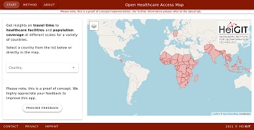
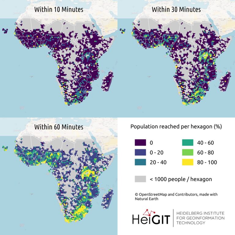
It’s been a little longer than a month since we published the Open Healthcare Access Map. Last week we rolled out all countries of Sub-Saharan Africa. Today all countries of…
A couple of viruses are of global interest with respect to human health and well-being. These pathogens include the novel coronavirus SARS-CoV-2, Dengue, Chikungunya, Yellow fever, Zika and Ebola. These…
The Heidelberg Institute for Geoinformation Technology (HeiGIT) and the international humanitarian geospatial charity MapAction have signed a Memorandum of Understanding (MoU) outlining their plans to collaborate in a number of…
Last month we started the Open Healthcare Access Map. Initially, only a few countries were featured. Gradually, more countries and regions are now being added. Today we release all countries…
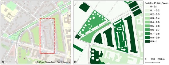
Public urban green spaces are important for the urban quality of life. Still, comprehensive open data sets on urban green spaces are not available for most cities. As open and…
The project “25 Mapathons“ goes into the next phase. Based on the experience of until today 17 OSM mapathons with German Red Cross (GRC) chapter and an extensive literature review…
Volunteered Geographic Information (VGI) such as OpenStreetMap (OSM) is often defined as the collaborative acquisition of geographic information and local knowledge by volunteers, amateurs or professionals (Goodchild, 2007). The increasing…
Gemeinsam mit dem Deutschen Roten Kreuz (DRK) hat das HeiGIT heute das Dokument “Die häufigsten Fehler beim „mappen“ mit dem iD-Editor & deren Lösung” veröffentlicht. Das Dokument ist komplementär zum…
Last week we introduced Open Healthcare Access Map. Our new web application for interactively sharing results of accessibility estimates based on OpenStreetMap healthcare facilities and openrouteservice isochrones. A new update…
Hello dear friends of the disastermappers heidelberg! At the moment, the Heidelberg International Weeks against Racism 2021 are running – and the disastermappers are also taking part! Why? The unequal…