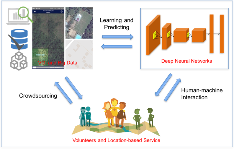
Recently, deep learning has been widely applied in pattern recognition with satellite images. Deep learning techniques like Convolutional Neural Network and Deep Belief Network have shown outstanding performance in detecting ground objects like buildings and roads, and the learnt deep features are further applied in some prediction tasks like poverty and population mapping. On the other hand, such deep learning techniques usually rely on a large set of labeled training samples (i.e., human knowledge) for supervision. Volunteered Geographic Information (VGI) like OpenStreetMap provides a way to easily get a large set of such training data. Meanwhile, utilizing VGI for deep learning brings new technical challenges like
- How to deal with the noise in VGI data which are usually contributed by common people instead of experts, and
- How to transfer learnt models from area to area and from time to time, as there is usually a gap between the volunteer labeled targets and the unknown targets waiting for prediction.
A chapter in a recently published book by Karimi and Karimi (2017) introduces the current work in this field, including satellite image classification with deep learning, challenges and solutions in utilizing VGI data, esp. OpenStreetMap (OSM) but also MapSwipe data, domain adaptation and feature transferring, and applications.
First the typical deep learning studies in satellite image classification as well as some classic benchmarks are analyzed, and then the chapter focuses on the problem of automatically extracting big sample sets from VGI data for the supervision of training deep networks. Two main technical challenges about sample noise and domain adaptation as well as their solutions in VGI data quality research and machine learning research are introduced. Finally, several applications where the above techniques and data can be applied are presented.
The chapter builds upon work done in the deepVGI project at HeiGIT (Heidelberg Institute for Geoinformation Technology) at Heidelberg University.
Chen, J., Zipf, A. (2017): Deep Learning with Satellite Images and Volunteered Geographic Information (VGI). In: Karimi, H. A. and Karimi, B. (eds.): Geospatial Data Science Techniques and Applications. Chapter 3. pp. 63-78. crc press. Taylor & Francis.

http://mapswipe.geog.uni-heidelberg.de/
http://mapswipe.org
HeiGIT.org

