Together with the German Federal Agency for Cartography and Geodesy (BKG) we released a new version of the ohsome dashboard, introducing a new indicator for assessing the thematic accuracy of land cover data in OpenStreetMap (OSM). This development is part of a broader project together with BKG on OSM data quality evaluation.
New indicator: Thematic Accuracy of Land Cover
The new indicator provides a quantitative assessment of the correctness of land use classifications in OSM by comparing them with the official CORINE Land Cover (CLC) data of BKG. The dataset works as a benchmark to evaluate the differences between OSM land use classes and the actual classification.
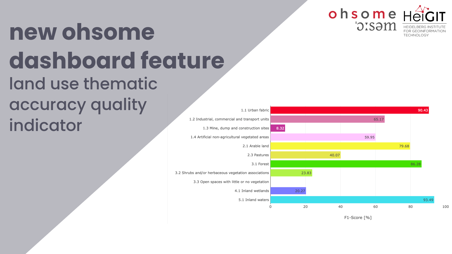
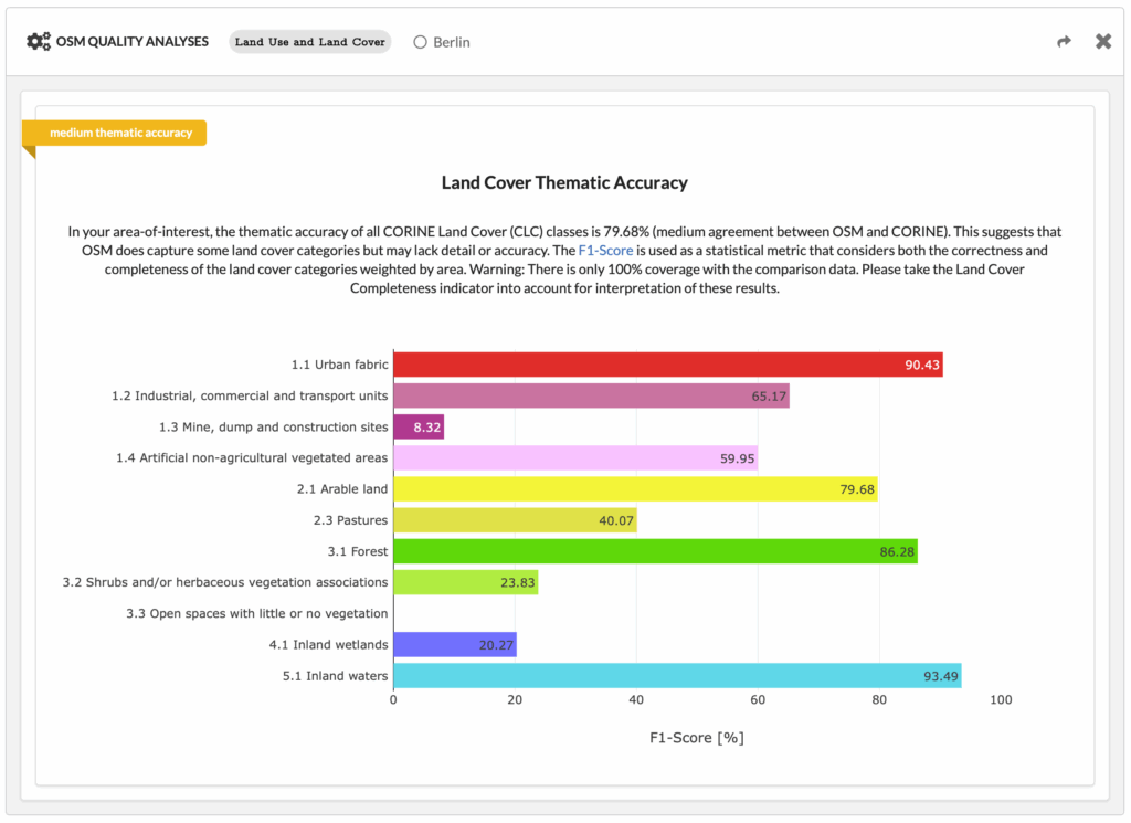
This comparison is based on an analysis of all land use polygons in OSM. It produces a weighted thematic accuracy score, where weights are assigned according to the areal extend of each class. Additionally, the results are presented in a bar chart, showing the accuracy for each sector.
The figure shows an analysis of the Land Cover Thematic Accuracy using the example of Berlin, Germany, broken down into individual categories. The brief description shows that the thematic accuracy of all CORINE Land Cover (CLC) data is 79.68%. This means that the data in OSM matches the official data by almost 80%. The two classes urban fabric and forest are particularly noteworthy. In both categories the thematic accuracy is (just) over 90%, meaning that the data in these categories match almost 90%.
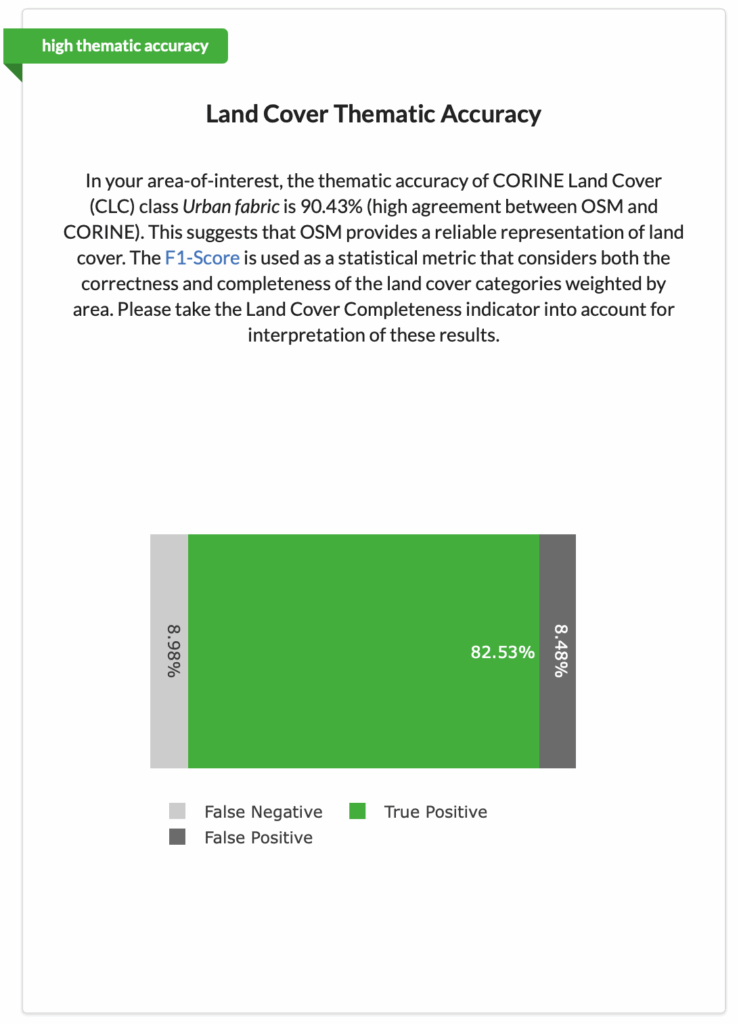
At the same time, a chart can be generated to quantify the correspondence between OSM and CORINE Land Cover for a single land cover class. To do so, a specific land cover class needs to be selected. This enables a more detailed analysis and can provide information on over- or underrepresentation of the data across categories.
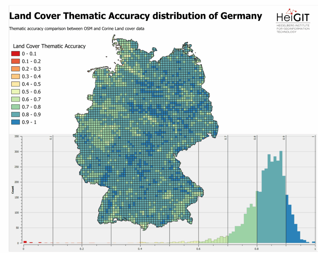
This map provides a comprehensive overview of the thematic accuracy distribution of land cover in Germany. It compares the thematic accuracy of OSM and CORINE Land cover data and visualizes the bar charts on a spatial scale. Regions characterized by a high level of accuracy are represented by blue tiles, while red tiles indicate areas where thematic accuracy is low. As demonstrated in the diagram, the majority of Germany’s regions have attained a Land Cover Thematic Accuracy of 0.7 and above.
Implementation and Use
The thematic accuracy indicator is now fully integrated into the dashboard. The users can visualize class-specific thematic accuracy and select individual categories for a more detailed comparison. It provides a valuable tool for researchers, the OSM community and public administration to understand the reliability of OSM land use data.
Currently, the analysis is only available in Germany, but with plans to extrend across Europe in future updates.
Cooperation with German Federal Agency for Cartography and Geodesy (BKG)
The project is accomplished in cooperation with the German Federal Agency for Cartography and Geodesy (BKG), in particular with the department Geodata. The BKG is pursuing the long-term goal of establishing open source data, particularly OpenStreetMap data, as an alternative to commercial services in the federal administration. It supports various organizations and associations such as FOSSGIS e.V. and HeiGIT that work with open geodata and open technology solutions. As one such institute, HeiGIT has been cooperating with BKG, with a specific focus on investigating the data quality of OSM data since the end of 2024, with a specific focus on investigating the data quality of OSM data. Tools such as the ohsome dashboard are provided for this purpose.
The Land Cover Thematic Accuracy Indicator enables a comprehensive and standardized assessment of the quality of the OSM dataset. This enables a qualitative classification of the individual regional data. The results of the ohsome dashboard serve as the basis for this classification and can be evaluated directly by users within federal administration organizations.
Try the new ohsome dashboard indictor and find out more about the thematic accuracy of land cover in OSM: ohsome – dashboard
Learn more about the OpenStreetMap Quality project: OpenStreetMap Quality