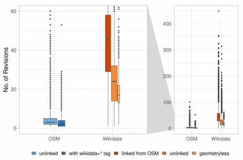
Featured Figure: Object history revisions from Alishiba Dsouza of the University of Bonn, GIScience’s Moritz Schott and Prof. Dr. Sven Lautenbach delivered the academic track talk, “Comparative Integration Potential Analyses of OSM and Wikidata – the Case Study of Railway Stations” slides.
With a new year of papers, workshops, and publications ahead of us, the team at GISciene and HeiGIT are looking back and building on the many contributions to last year’s conferences. During the previous summer’s FOSS-Community “conference-athon” in Florence, when QGIS-Meeting, State of the Map, HOT unSummit and FOSS4G all occurred in the same short span, the team participated in a flurry of events showcasing ohsome, case studies, and community projects.
Beginning with State of the Map 2022, HeiGIT’s Benjamin Herfort, Michael Auer, Matthias Schaub, and Rafael Troilo of the Big Spatial Data Analytics team led the Saturday workshop “Analyzing changes in OSM over time – full history access to OSM data through the ohsome framework” building upon the OpenStreetMap History Database (OSHDB) and ohsome framework, which were introduced to the OSM community at State of the Map 2018 in Milan. The idea for OSHDB itself is over a decade old, stemming from HeiGIT’s Scientific and Managing Director Prof. Dr. Alexander Zipf in 2010. OSHDB Version 1.0 was released this past December, with a press release, a review of the development process, and a social media campaign of favorite use cases and reflections to celebrate the announcement. Benjamin Herfort and Rafael Troilo outlined OSHDB and ohsome for workshop participants and then walked them through hands-on examples focusing on re-tagging, OSM-based metrics, and contributions in the OSM space.
The next day, Alishiba Dsouza of the University of Bonn, GIScience’s Moritz Schott and Prof. Dr. Sven Lautenbach delivered the academic track talk, “Comparative Integration Potential Analyses of OSM and Wikidata – the Case Study of Railway Stations” based on their short paper of the same name. The presentation, with slides and video available online, analyzes a series of comparative data insights to explore the potential and implications of integration between knowledge graphs and OSM using the ohsome api for their dataset and community metrics. The researchers compare OSM to Wikidata in size, structure, and distribution and then discuss the respective online communities for each tool. Using railway stations as a case study, the authors found divergent trends in the coverage and amount of contributions in the two communities, elucidating differences in the goals and focuses of each group.
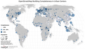
Following this, Benjamin Herfort led the 5-minute academic track lightning talk, “Inequalities in the completeness of OpenStreetMap buildings in urban centers” drawing from his short paper. The talk, with slides and video available, discusses the stark data inequalities in OSM data. These inequalities have persisted despite humanitarian- and corporate-organized mapping activities, as shown by an analysis using a machine learning regression method based on generalized additive models (GAMs) to calculate the OSM building completeness for 13,135 urban centers. The results point to the need to apply multi-scale building completeness measures to account for missing data and the necessity of completeness maps and socio-demographic information to make sure “nobody is left behind.”
In addition to the workshops and presentations, Marcel Reimuth, Maximiliane Kitzunger, and Prof. Dr. Alexander Zipf also participated in the call-for-posters with thier contribution on access to safe abortions in Germany, detailing current accessibility by car, the situation for abortion seekers who may require a surgical abortion or may not speak German, and how the situation might evolve after the repeal of a law banning the advertisement of abortion.
Finally, Moritz Schott held a talk at FOSS4G presenting OSM Element Vectorization, a new tool that enables users to calculate a large set of quality indicators for single OSM elements. By integrating multiple aspects of the OSM ecosystem into one workflow that allows the quantitative assessment of selected OSM elements or all elements in a defined region, a vectorization of single OSM elements is produced as a machine-readable result. In an example study, the tool was used to uncover some interesting tendencies in OSM’s land-use data.
Last year’s conference-athon gave HeiGIT and GIScience researches ample opportunity to present the most cutting-edge research in the geospatial technology and geography space. As submissions begin for this summer’s conferences, we look forward to expanding upon our past work and introducing the world to the next round of projects to enable faster routing, quality research, and geospatial analysis. To stay updated on all the promising research to come, check out our GIScience and HeiGIT blogs and make sure to follow us on Twitter, LinkedIn, and Mapstodon.