Benjamin Herfort and his colleagues Sven Lautenbach, João Porto de Albuquerque, Jennings Anderson and Alexander Zipf published an article in the renowned journal Nature Communications (Impact Factor 2023: 17.7). In their article, they address the uneven distribution of OpenStreetMap data worldwide, which can have an impact on research results and humanitarian operations. They provide solutions on how experts can better deal with such data gaps and provide analyses on the completeness of building data in 13,189 cities worldwide.
- Herfort, B., Lautenbach, S., Porto de Albuquerque, J. et al. A spatio-temporal analysis investigating completeness and inequalities of global urban building data in OpenStreetMap. Nat Commun 14, 3985 (2023). https://doi.org/10.1038/s41467-023-39698-6
The Problem:
Cities are growing: More and more people worldwide are living in urban regions. This is especially true for low-income countries, where the urban population has grown strongly since 2001. And this trend is not stopping anytime soon, experts say. This puts a challenge on achieving the Sustainable Development Goals (SDGs), especially the SDG 11 which aims at inclusive, safe, resilient and sustainable cities: For the SDGs to be realized, reliable data is necessary for better monitoring urban regions. However, especially for low-income countries, official data are often outdated, inaccessible, or not available in standard formats.
Researchers, humanitarian organizations and policy actors, such as Médecins Sans Frontières and UN Habitat, heavily rely on OpenStreetMap data, especially in regions where official data are sparse. However, there is a problem that is often acknowledged only little or not at all: OSM data are unevenly distributed. While for some regions, data are near complete and up-to-date, others are hardly mapped at all and therefore strongly underrepresented in the global data. This bias is where Herfort et al. have placed the focus of their research.
The Approach:
With the help of HeiGIT’s ohsome framework, which allows for an analysis of historical OSM data, Herfort et al. used more than 15 years of data material to investigate how complete the building data on OpenStreetMap is for 13,189 urban areas – and where data is still missing. To do this, they first calculated where building stock is located worldwide: Especially in East and Southeast Asia, the building density is particularly high. They then compared these results to the building data on OpenStreetMap – and found that for regions with a high building stock remarkably little data are available.
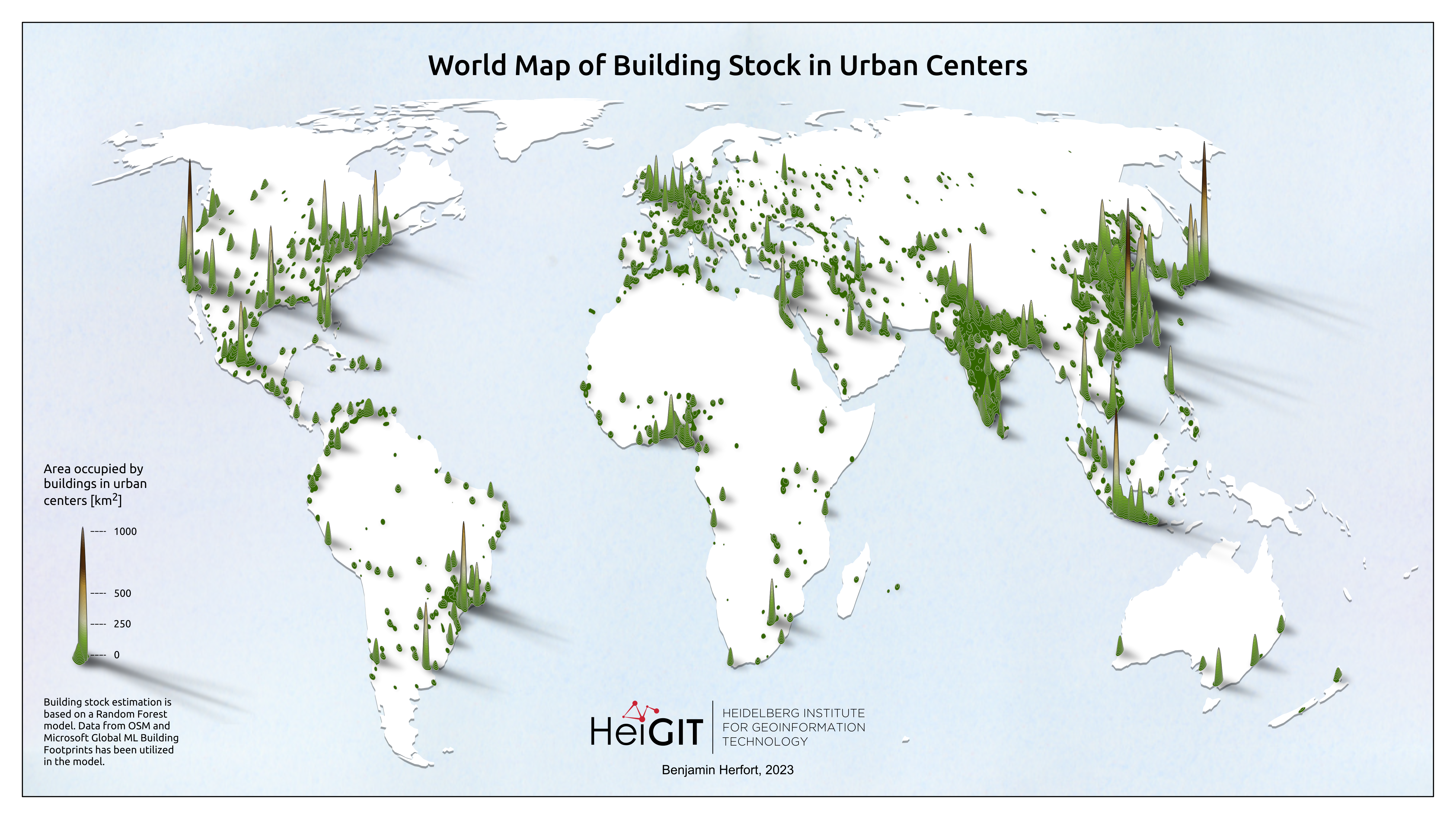
Based on calculations, the map shows which parts of the earth’s surface are covered with buildings.
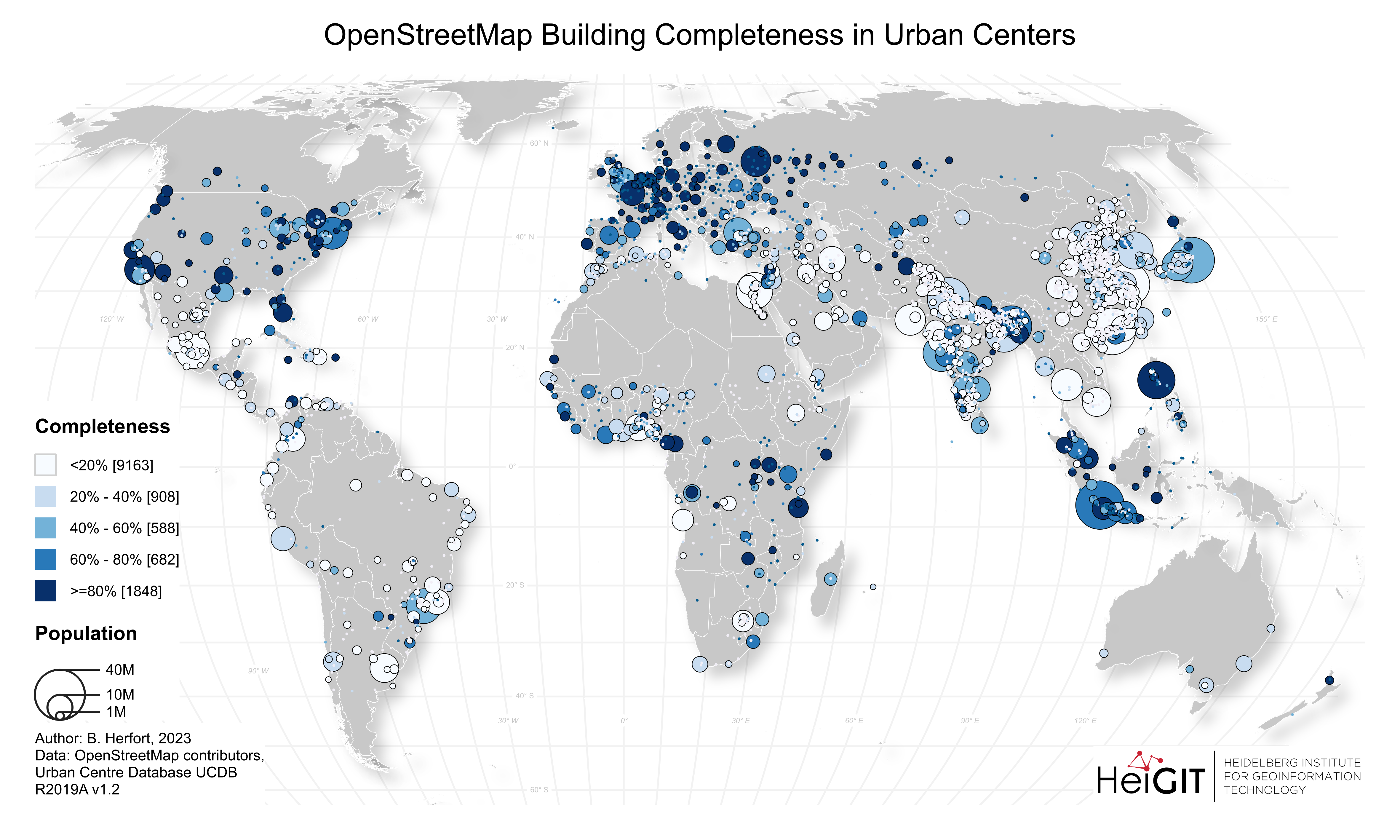
The map shows how many of the actual buildings in cities worldwide are actually represented as mapped data in OpenStreetMap.
Especially for these regions with a medium and high Human Development Index (HDI), for example areas in India, China, Indonesia but also Latin America, the completeness of the data in OSM is particularly low. Only few of the buildings are actually mapped. In regions with a low HDI, on the other hand, for example on the African continent, the completeness is higher: Here, cities are mapped rather well. This can be attributed mainly to the strong influence of humanitarian mapping activities: About 10% of all global building data in urban areas come from such events, in Sub-Saharan Africa it is even more than 50%.
Humanitarian mapping actions, in which volunteers map objects on the earth’s surface based on aerial and satellite imagery, account for a large share of global building data overall. Such collective mapping activities are essential for humanitarian organisations, for gathering data for long-term monitoring as well as in the event of a crisis where first responders quickly need up-to-date data.
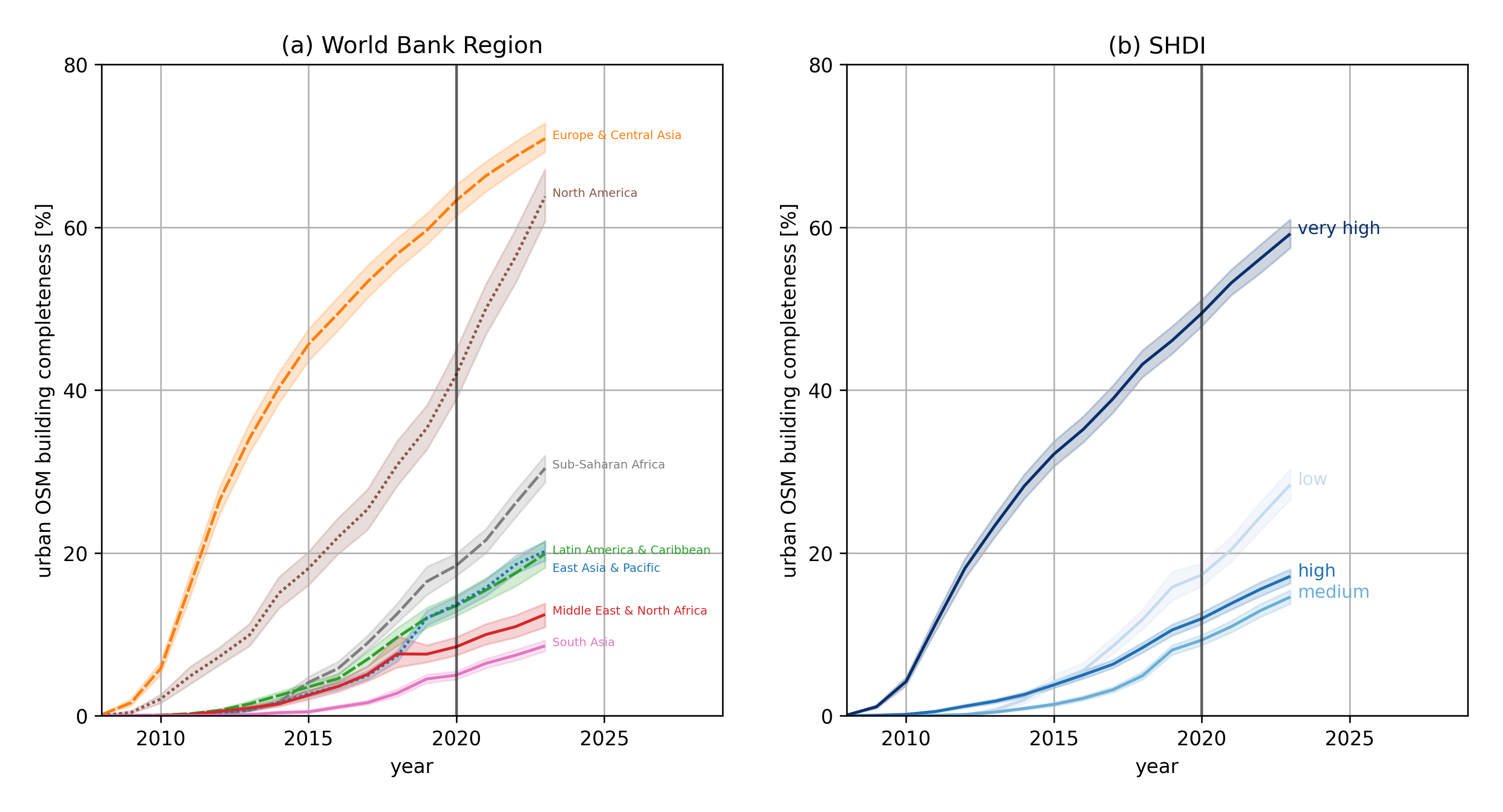
The diagrams show that building data in OpenStreetMap is particularly available for regions with a very high HDI index (Europe and North America). In areas with a low index and higher disaster risk (such as sub-Saharan Africa), humanitarian mapping actions have contributed to the completeness of data. Regions with high and medium HDI, on the other hand, are strongly underrepresented in OSM (such as Latin America, the Middle East, and South and Southeast Asia).
The benefit:
Herfort et al. provide completeness data for building stock in 13,189 urban regions around the world via the ohsome framework: Click here for trying it out yourself!
The short demo-video below shows the differences in the completeness of building data between Heidelberg in Germany, Santiago de Chile, and the city of Sévaré in Mali: While in Heidelberg, 97% of the buildings have been mapped in January 2023, the completeness for Santiago de Chile lies only just above 25%. In Mali, on the other hand, you can see that several small villages have been mapped carefully. Large jumps in completeness, as is seen for Sévaré, indicate the influence of mapping events.
Watch here a short demo of the tool and see the differences regarding the completeness between Heidelberg (Germany), Santiago de Chile, and the city of Sévaré in Mali.
This information can help researchers, humanitarian organizations and other stakeholders to better understand and assess OpenStreetMap data. For example, it can indicate which regions in global studies are better left out to not bias the results. In such cases, researchers can use the building data estimated by Herfort et al. as a proxy. They can also serve as a basis for decision-making where more data need to be collected, or where mapping actions have already provided a reliable data basis. Such insights are essential, also against the background of the Sustainable Development Goals: The goal “no one is left behind” can only be achieved if reliable data exists on where and how many people are actually living in urban spaces.
Next Steps:
Benjamin Herfort sees the results of this analysis as an important base for further research: For example, the potential and quality of AI-assisted mapping and datasets must be considered in light of the latest technological developments. Furthermore, it is important to use the findings to strengthen the potential of local communities: “Our results show in which cities and regions outside Europe local OSM communities have managed to create a very detailed and complete OSM map. But at the same time, we see many other cities with similar socio-economic characteristics that have not yet been mapped to the same extent.” Together, they want to learn from the successful mapping projects and use the findings to support communities in poorly mapped areas, he said. In this way, the findings of Herfort et al. can help achieve the SDGs and a more equitable and sustainable future for urban regions.