The Humanitarian OpenStreetMap Team (HOT) has launched an activation to support humanitarian operations responding to the impact of Cyclone Idai. These efforts were already supported by more than 1500 mappers of the global OpenStreetMap (OSM) community that contribute geodata about the affected regions in Mozambique and the surrounding countries.
The team at HeiGIT (Heidelberg Institute for Geoinformation Technology) for sure is also supporting these efforts through their services and applications that facilitate efficient use of the OSM data provided. The openrouteservice for disaster management now provides updates almost hourly (every 1.5 h) to consider always the latest OSM data available.
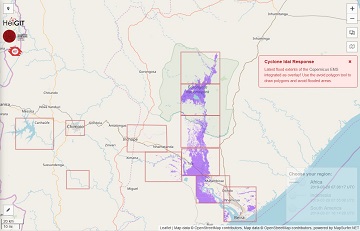
To better support the response to Cyclone Idai we have furthermore integrated latest flood extents provided by the Compernius Emergency Management Service, Activation EMS348. To avoid those areas, calculate your route, draw a polygon around the areas you want to avoid, and the route will automatically be recalculated.
You can use it here: https://disaster.openrouteservice.org/
We are currently evaluating further flood extent layers to be integrated in our routing service. We will keep you updated.
The flooding data is also available as Web Map Service (WMS) layer. Also related to disasters is a map layer called “OSM Elements at Risk” showing critical infrastructures and similar objects that need special attention in disasters based on OpenStreetMap data. Please contact us if you need access to one of those map layers.


