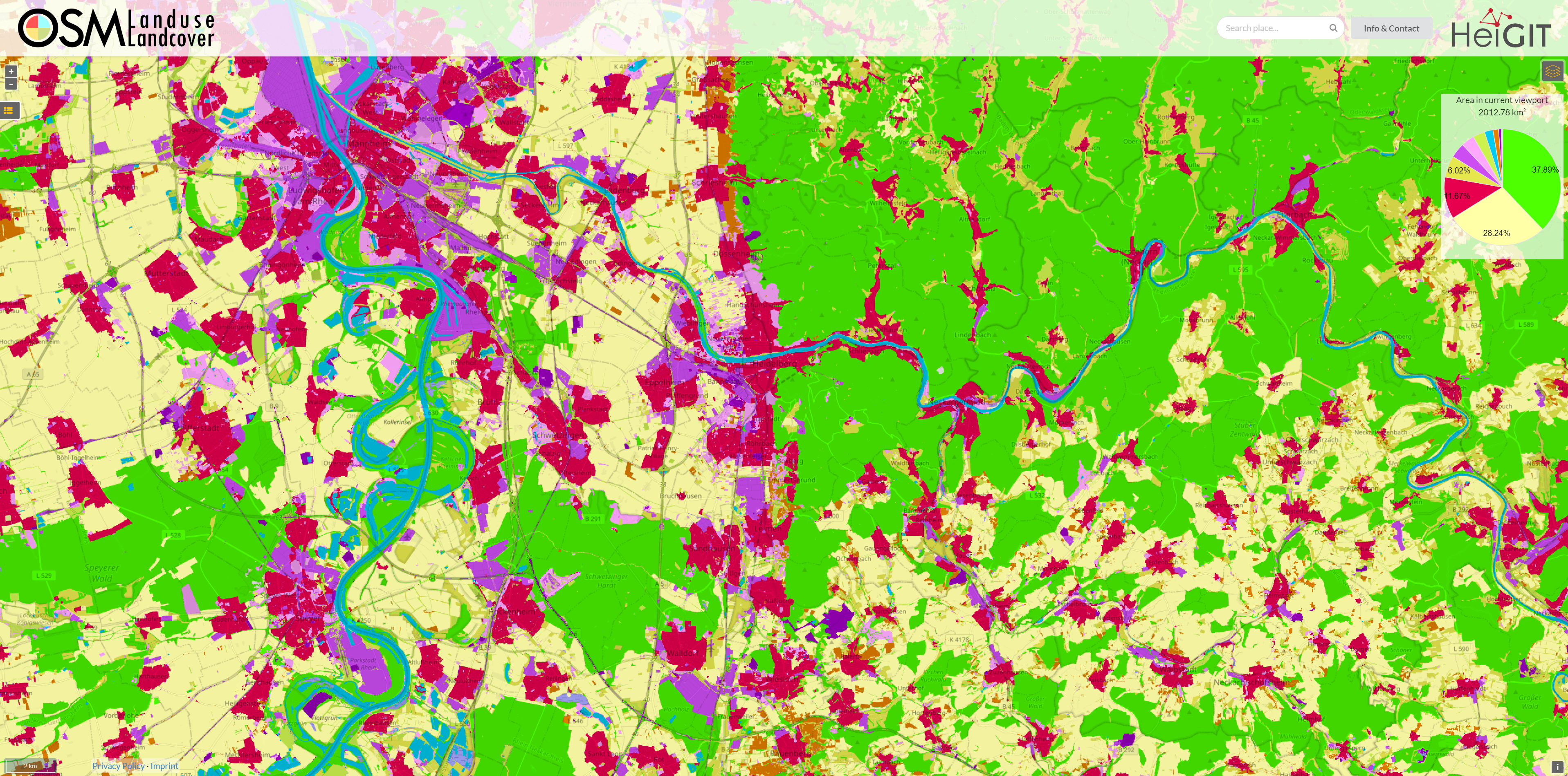
We are excited to announce that the data displayed on OSM – Landuse is now freely accessible. These data sets offer valuable insights and can be utilized for various applications.
Urban planners will find the data useful for development projects and zoning regulations, while environmental researchers can study land use changes and their impact on ecosystems. Farmers might optimize land use for crop production and resource management, and disaster management teams may identify vulnerable areas and improve evacuation plans. Real estate developers gain valuable information for investment decisions. Transportation agencies could plan and optimize routes more effectively. Scholars and students benefit from using the data for research projects, and policymakers have the opportunity to craft sustainable land use policies. Explore the platform to discover the full potential of these datasets.
What Data is Available?
The available data consists of TIF tiles (GeoTIFF) for each country of the European Union and United Kingdom. These data were created by classifying Sentinel-2 imagery using a deep learning model trained on OpenStreetMap (OSM) land use and land cover features.
Details on the Classification
The classification values in the raster dataset correspond to a subset of the well-known CORINE Land Cover Classification. This classification includes various land use categories such as agricultural areas, forests, water bodies, and urban areas. By using Sentinel-2 imagery and OSM data, we have been able to create a land cover map that is useful for a wide range of purposes.
Data Sources and Methodology
-
Sentinel-2 Imagery: These high-resolution satellite images provide an excellent foundation for analyzing and classifying land surfaces.
-
OpenStreetMap (OSM): OSM provides comprehensive data on land use and land cover. Specific OSM keys were used to form the respective classes.
-
Deep Learning: Our model is specifically trained to accurately recognize and classify different land cover categories based on Sentinel-2 images and OSM data.
Using the Data
These datasets can now be downloaded directly from here.
We are eager to see the innovative projects and applications that will emerge from the use of this open data and look forward to your feedback and experiences.
Related Project & Literature
-
LandSense: A Citizen Observatory and Innovation Marketplace for Land Use and Land Cover Monitoring
-
Schultz, M., Voss, J., Auer, M., Carter, S., & Zipf, A. (2017). Open land cover from OpenStreetMap and remote sensing. International Journal of Applied Earth Observation and Geoinformation, 63, 206–213. https://doi.org/10.1016/j.jag.2017.07.014
-
Voß, J., Auer, M., Schultz, M. & Zipf, A. (2017): Einsatz von OpenStreetMap Daten zur Erstellung von Landnutzungsprodukten am Beispiel von OSM Landuse Landcover. Symposium für Angewandte Geoinformatik AGIT 2017. Salzburg