We would like to congratulate Dr. Christina Ludwig on successfully defending her PhD on how to map urban green spaces using OpenStreetMap (OSM) data last month.
In her thesis Christina first analyzed how urban green spaces are mapped in OSM and how this changes across geographic regions, revealing strong regional variations driven by factors such as culture, climate or mapping activity. For example, cemeteries are very vegetated in Germany, but not in Tel Aviv (Ludwig et al., 2019). And while German parks mostly contain benches and waste bins in OSM, public parks in Japan are often marked by public toilets instead (Ludwig et al., 2021a). These findings highlight the need to interpret the meaning of OSM tags regarding the presence of (public) green spaces based on the local context in order to ensure valid results of subsequent analyses.
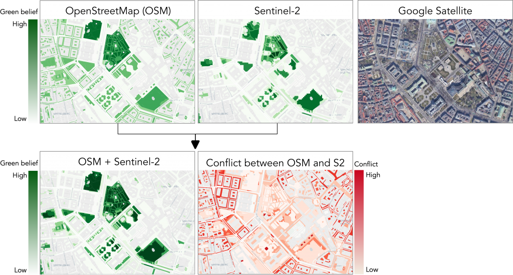
For this reason, Christina developed a method to map urban green spaces using OSM data and Sentinel-2 satellite imagery which is locally adapted and considers the data-source specific uncertainties such as missing data in OSM and the limited sensor resolution of Sentinel-2 (see Figure 1). In a second step, a Bayesian model was used to further distinguish between private and public green spaces (Ludwig et al., 2021b).
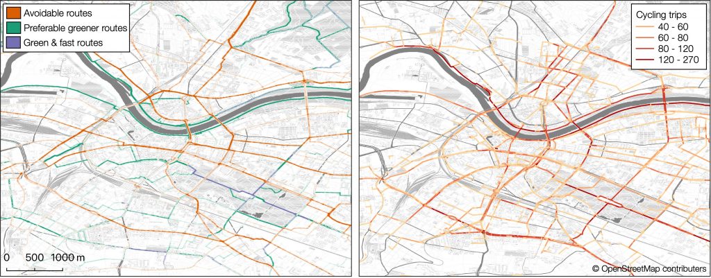
This locally adapted green space data set was subsequently used to enhance the ‘green’ route suggestions for pedestrians and cyclists in openrouteservice (ORS), which preferably lead alongside vegetated areas to increase pleasantness. You can test it yourself using the meinGrün App, available for Heidelberg and Dresden. To analyse the quality of the road network for pedestrians and cyclists in these two cities, a comparison of simulated fast and green routes was conducted (Ludwig et al., 2021c). This revealed sections in road the network that enable cyclists and pedestrians to reach their destination via a fast and green route, as well as greener alternative routes to avoid less pleasant road sections (Figure 2).
We would like to express our sincerest appreciation for her work and we are looking forward to working together on future projects.
Related publications:
C. Ludwig and A. Zipf (2019): Exploring regional differences in the representation of urban green spaces in OpenStreetMap. In Proceedings of the “Geographical and Cultural Aspects of Geo-Information: Issues and Solutions” AGILE 2019 Workshop, June17th 2019, Limassol, Cyprus.
C. Ludwig, S. Fendrich, and A. Zipf (2021a): Regional variations of context-based association rules in OpenStreetMap. Transactions in GIS, 25(2):602–621, ISSN 1467-9671. doi:10.1111/tgis.12694.
C. Ludwig, R. Hecht, S. Lautenbach, M. Schorcht, and A. Zipf (2021b): Mapping Public Urban Green Spaces Based on OpenStreetMap and Sentinel-2 Imagery Using Belief Functions. ISPRS International Journal of Geo-Information, 10(4):251, Apr. ISSN 2220-9964. doi: 10.3390/ijgi10040251.
C. Ludwig, S. Lautenbach, E.-M. Schömann, and A. Zipf (2021c): Comparison of Simulated Fast and Green Routes for Cyclists and Pedestrians. In K. Janowicz and J. A. Verstegen, editors, 11th International Conference on Geographic Information Science (GIScience 2021) – Part II, volume 208 of Leibniz International Proceedings in Informatics (LIPIcs). DOI: 10.4230/LIPIcs.GIScience.2021.II.3
Hecht, R., Artmann, M., Brzoska, P., Burghardt, D., Cakir, S., Dunkel, A., Gröbe, M., Gugulica, M., Krellenberg, K., Kreutzarek, N., Lautenbach, S., Ludwig, C., Lümkemann, D., Meinel, G., Schorcht, M., Sonnenbichler, A., Stanley, C., Tenikl, J., Wurm, M., and Zipf, A. (2021): A WEB APP TO GENERATE AND DISSEMINATE NEW KNOWLEDGE ON URBAN GREEN SPACE QUALITIES AND THEIR ACCESSIBILITY, ISPRS Ann. Photogramm. Remote Sens. Spatial Inf. Sci., VIII-4/W1-2021, 65–72,
Novack, T., Wang, Z., & Zipf, A. (2018). A System for Generating Customized Pleasant Pedestrian Routes Based on OpenStreetMap Data. Sensors, 18(11), 3794. MDPI AG. Retrieved from