Volunteered Geographic Information (VGI) such as OpenStreetMap (OSM) is often defined as the collaborative acquisition of geographic information and local knowledge by volunteers, amateurs or professionals (Goodchild, 2007). The increasing availability and importance of local data in OSM is largely acknowledged in VGI projects. Local knowledge provides access to a plethora of contextual information and enables the answering of more localized questions. The local knowledge is also considered as an important indicator for measuring quality features of OSM data (Herfort et al. 2021, Nes & Zipf 2012, Neis et al. 2013, Klonner et al. 2021). Unfortunately, most studies have not touched on local data in OSM in sufficient details. Yet, recently related work deals with analysing and classifying data production in OSM (Grinberger et al. 2012, Schott et al. 2021).
The concept of “localness” is debated in the OSM community due to ambiguities in reality. Our interest is to create a classification schema for measuring local data in OSM. This will provide an initial step for building consensus among local community mappers and help to assess the completeness of local OSM data. We challenge ourselves to uncover general and specific classification schema by interviewing local community mappers. The questions we seek to address are:
- What exactly are local OSM data?
- What do organisations and local communities have in common with respect to their definition/perception of local data in OSM?
- How can we develop a classification schema for measuring local data in OSM that is ‘fit-for-purpose’ for organisations and OSM communities?
The outcome of the discussion will help to develop an conceptual framework which will be used to create generalized workflow for measuring local data contributions and contributors. Moreover, it will help to identify archetypes for places representing a variety of contextual information and data completeness levels.
To begin, we have expanded on an existing classification schema by Rebecca Firth showing different level of details of OSM (see Twitter post). The classification schema was developed in the context of humanitarian mapping. Therefore, we expanded it to cover several application as shown in Fig 1. This was done to facilitate discussion with local community mappers and experts. We will revise it after discussing with the OSM community. After the design of the classification framework, we will take advantage of the ohsome API to design filters for extracting local data in OSM for analysis. Spatial and temporal analysis will be carried out to provide insight into local data completeness as well as the awareness of local data in OSM which can support several applications.
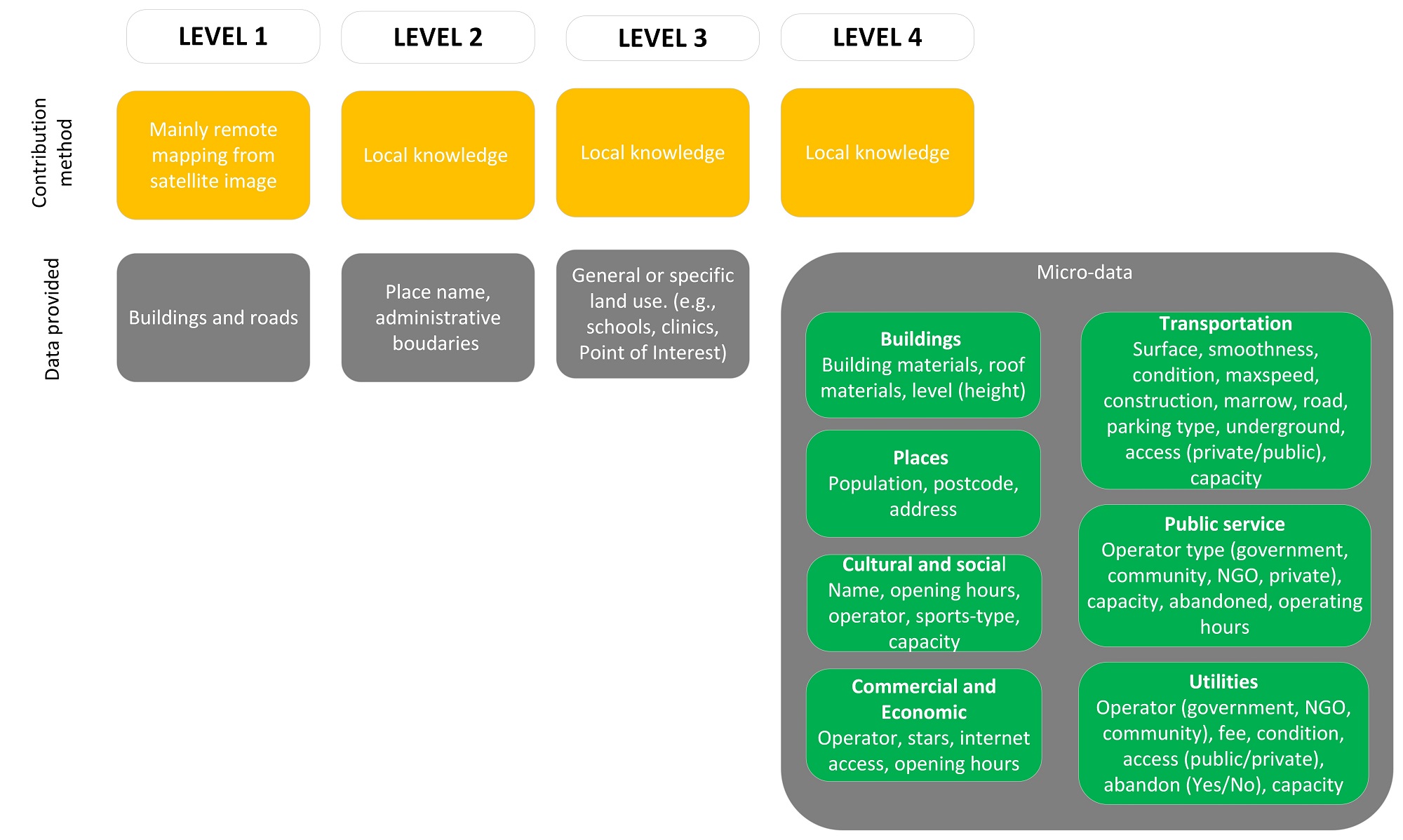
Fig 1 First draft of an OSM local data classification schema.
References and related literature
- Goodchild, M. F. (2007). Citizens as sensors: The world of volunteered geography. GeoJournal, 69(4), 211–221. https://doi.org/10.1007/s10708-007-9111-y
- Herfort, B., Lautenbach, S., Porto de Albuquerque, J., Anderson, J., Zipf, A. (2021): The evolution of humanitarian mapping within the OpenStreetMap community. Scientific Reports 11, 3037 (2021).
DOI: 10.1038/s41598-021-82404-z - Neis, P. & Zipf, A. (2012): Analyzing the Contributor Activity of a Volunteered Geographic Information Project – The Case of OpenStreetMap. ISPRS International Journal of Geo-Information. Vol.1(2), pp.146-165. MDPI. DOI:10.3390/ijgi1020146 .
- Neis, P., Zielstra, D. & Zipf, A. (2013): Comparison of Volunteered Geographic Information Data Contributions and Community Development for Selected World Regions. Future Internet. Vol. 5, pp. 282-300.
- Klonner, C., Hartmann, M., Dischl, R., Djami, L., Anderson, L., Raifer, M., Lima-Silva, F., Degrossi, L. C., Zipf, A., de Albuquerque, J. P. (2021): The Sketch Map Tool Facilitates the Assessment of OpenStreetMap Data for Participatory Mapping.ISPRS International Journal of Geo-Information. 10:130. https://doi.org/10.3390/ijgi10030130
- Grinberger, A.Y., Schott, M., Raifer, M., Zipf, A. (2021): An analysis of the spatial and temporal distribution of large‐scale data production events in OpenStreetMap. Transactions in GIS. 2021; 00: 1– 20.
https://doi.org/10.1111/tgis.12746 - Schott, M., Grinberger, A.Y., Lautenbach, S., Zipf, A. (2021): The Impact of Community Happenings in OpenStreetMap — Establishing a Framework for Online Community Member Activity Analyses. ISPRS Int. J. Geo-Inf. 2021, 10, 164. https://doi.org/10.3390/ijgi10030164