Recently videos with our contributions by HeiGIT to the FOSS4G conference were put online. Did you miss the event? Now you can watch whenever you like 🙂
Benni by HeiGIT explains who to use the ohsome.org framework to develop an OSM Confidence Index to support humanitarian mapping
https://www.youtube.com/watch?v=DWkISL4qbME
FOSS4G 2021 Using the ohsome framework to develop an OSM Confidence Index to support humanitarian mapping
Together with Johnny Henshall from British Red Cross Benni also introduces the mobile crowdsourcing App MapSwipe – including the latest project types that we developed and added recently.
https://www.youtube.com/watch?v=DIrPPKUS2_k
FOSS4G 2021 MapSwipe – an open-source mobile app putting communities on the map
Enjoy!

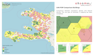
Figure 1: OSM building completeness in Haiti based on a comparison to the Global Human Settlement Layer population
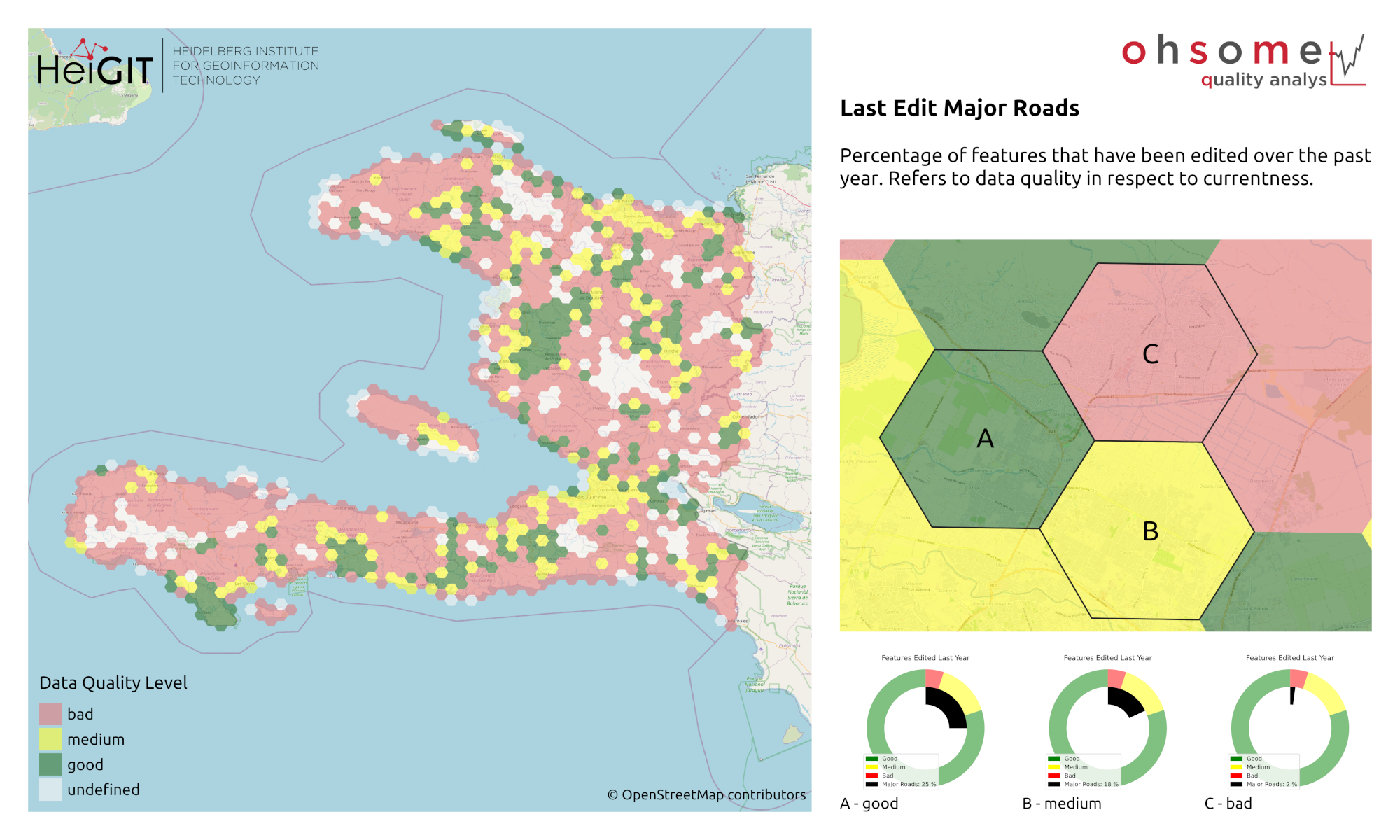
Figure 2: Currentness of OSM roads in Haiti. This is an intrinsic quality indicator taking into account the share of features edited over the past year.
More MapSwipe related news: http://giscienceblog.uni-hd.de/tag/mapswipe/
- The initial MapSwipe idea and prototype developed by us:
- Albuquerque, J. P., B. Herfort, and M. Eckle. “The tasks of the crowd: A typology of tasks in geographic information crowdsourcing and a case study in humanitarian mapping.” Remote Sensing 8.10 (2016): 859.
- First analysis of MapSwipe data quality:
- Herfort, B., Reinmuth, M., Albuquerque, J.P., Zipf, A. (2017): Towards evaluating crowdsourced image classification on mobile devices to generate geographic information about human settlements. Proceedings of the 20th AGILE Conference on Geographic Information Science (2017). Wageningen, NL, Association of Geographic Information Laboratories in Europe: 1-7.
- Recent work on combining machine learning, artificial intelligence and MapSwipe:
- Herfort, B., Li, H., Fendrich, S., Lautenbach, S., Zipf, A. (2019): Mapping Human Settlements with Higher Accuracy and Less Volunteer Efforts by Combining Crowdsourcing and Deep Learning. Remote Sensing 11(15), 1799. https://doi.org/10.3390/rs11151799
- Chen, J., Y. Zhou, A. Zipf and H. Fan (2018): Deep Learning from Multiple Crowds: A Case Study of Humanitarian Mapping. IEEE Transactions on Geoscience and Remote Sensing (TGRS). 1-10. https://doi.org/10.1109/TGRS.2018.2868748
- Li, H., Herfort, B., Zipf, A. (2019): Estimating OpenStreetMap Missing Built-up Areas using Pre-trained Deep Neural Networks. Proceedings of the 22nd AGILE Conference on Geographic Information Science, Association of Geographic Information Laboratories in Europe. Limassol, Cyprus.
- Overview about Missing Maps and Humanitarian Mapping:
- Herfort, B., Lautenbach, S., Porto de Albuquerque, J., Anderson, J., Zipf, A. (2021): The evolution of humanitarian mapping within the OpenStreetMap community. Scientific Reports 11, 3037 (2021). DOI: 10.1038/s41598-021-82404-z https://www.nature.com/articles/s41598-021-82404-z
- Scholz, S., Knight, P., Eckle, M., Marx, S., Zipf, A. (2018): Volunteered Geographic Information for Disaster Risk Reduction: The Missing Maps Approach and Its Potential within the Red Cross and Red Crescent Movement. Remote Sens., 10(8), 1239, doi: 10.3390/rs10081239.
OQT, the ohsome quality analyst relies on information from the OpenStreetMap (OSM) that has been processed using the ohsome OSM History Data Analytics Platform developed by HeiGIT. The aim of the ohsome framework is to make OpenStreetMap’s full-history data more easily accessible for various kinds of OSM data analytics tasks, such as data quality analysis, on a regional, country-wide, or global scale.
- OQT ohsome Blogposts
- Introducing the ohsome quality analyst (OQT)
- Behind the scenes of the ohsome quality analyst (OQT)
- The ohsome quality analyst goes public on Github with new release 0.3.0
- ohsome general idea & ohsome general architecture
- how to become ohsome blog series
Some ohsome Publications
- Raifer, Martin; Troilo, Rafael; Kowatsch, Fabian; Auer, Michael; Loos, Lukas; Marx, Sabrina; Przybill, Katharina; Fendrich, Sascha; Mocnik, Franz-Benjamin; Zipf, Alexander (2019): OSHDB: a framework for spatio-temporal analysis of OpenStreetMap history data. Open Geospatial Data, Software and Standards.
- Schott, M.; Grinberger, A. Y.; Lautenbach, S. & Zipf, A. (2021) The Impact of Community Happenings in OpenStreetMap – Establishing a Framework for Online Community Member Activity Analyses In: ISPRS Int. J. Geo-Inf. 10, no. 3: 164. https://doi.org/10.3390/ijgi10030164
- Grinberger, AY, Schott, M, Raifer, M, Zipf, A. (2021): An analysis of the spatial and temporal distribution of large‐scale data production events in OpenStreetMap. Transactions in GIS. 2021; 00: 1– 20. https://doi.org/10.1111/tgis.12746
- Witt, R.; Loos, L.; Zipf, A. (2021): Analysing the Impact of Large Data Imports in OpenStreetMap. ISPRS Int. J. Geo-Inf. 2021, 10, 528. https://doi.org/10.3390/ijgi10080528
- Fritz, O., Auer, M., Zipf, A. (2021). Entwicklung eines Regressionsmodells für die Vollständigkeitsanalyse des globalen OpenStreetMap-Datenbestands an Nahverkehrs-Busstrecken. AGIT ‒ Journal Für Angewandte Geoinformatik. 7-2021
- Auer, M.; Eckle, M.; Fendrich, S.; Griesbaum, L.; Kowatsch, F.; Marx, S.; Raifer, M.; Schott, M.; Troilo, R.; Zipf, A. (2018): Towards Using the Potential of OpenStreetMap History for Disaster Activation Monitoring. ISCRAM 2018. Rochester. NY. US.


