The availability of data on public transport is a prerequisite for numerous spatial data applications such as routing, accessibility analyses or route planning. OpenStreetMap (OSM) – as a global platform for Volunteered Geographic Information – is one of the options for sharing public transport data. The data completeness on OSM, however, is characterized by heterogeneity. Results of conventional approaches of quality assessment based on the comparison with reference data can thus not be applied to the entire dataset. Hence, the completeness of OSM data is usually analysed using intrinsic methods.
The 2021 AGIT symposium accepted our new paper that proposes a different approach for the global analysis of OSM data completeness: We generate “reference” data via a regression model from demographic and socio-economic indicators (such as population, built-up area density, anthropogenic nighttime light emission, fossil fuel CO2 emission) and sporadically available open General Transport Feed Specification (GTFS) data sets. Consequently, the predicted number of local public bus routes is compared with the number of existing features on OSM.
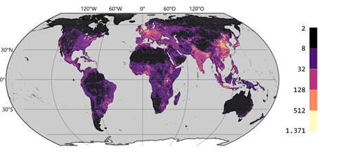
Predicted number of bus routes
OSM bus route data was aggregated on a global discrete hexagon grid with the ohsome API using ohsome2x. The results of the completeness analysis are available in the ohsome History Explorer (ohsomeHeX), together with a growing number of other layers related to the topic of public transport.
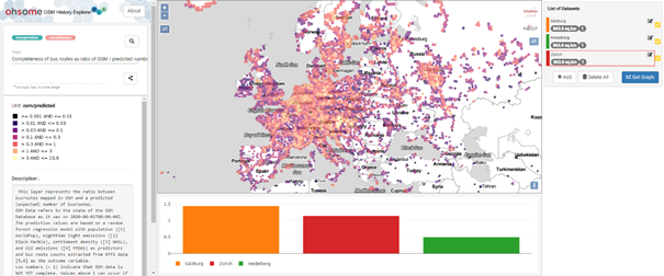
Visualisation of OSM bus route feature completeness on ohsomeHeX
Citation:
- Fritz, O., Auer, M., Zipf, A. (2021). Entwicklung eines Regressionsmodells für die Vollständigkeitsanalyse des globalen OpenStreetMap-Datenbestands an Nahverkehrs-Busstrecken. AGIT ‒ Journal Für Angewandte Geoinformatik. 7-2021
Related Literature:
- Raifer, Martin; Troilo, Rafael; Kowatsch, Fabian; Auer, Michael; Loos, Lukas; Marx, Sabrina; Przybill, Katharina; Fendrich, Sascha; Mocnik, Franz-Benjamin; Zipf, Alexander (2019): OSHDB: a framework for spatio-temporal analysis of OpenStreetMap history data. Open Geospatial Data, Software and Standards.
- Auer, M., Eckle, M., Fendrich, S., Kowatsch, F., Loos, L., Marx, S., Raifer, M., Schott, M., Troilo, R., & Zipf, A. (2018). Ohsome – eine Plattform zur Analyse raumzeitlicher Entwicklungen von OpenStreetMap-Daten für intrinsische Qualitätsbewertungen. AGIT ‒ Journal Für Angewandte Geoinformatik, 4.
- Roick, O., Hagenauer, J., & Zipf, A. (2011). OSMatrix—Grid based analysis and visualization of OpenStreetMap. State of the Map EU, Wien.