The current flooding in Germany has destroyed countless streets or temporarily made them impassable in the affected areas. HeiGIT is working on free and open solutions for humanitarian aid that are based on geodata. This particularly includes routing that incorporates current data from disaster areas, such as areas subject to flooding or destroyed streets.
To help with the current flood disaster in Germany and neighboring countries, HeiGIT has taken up-to-date flooding data derived from satellite images of the European Copernicus Emergency Mapping Service (EMS) and integrated them into the routing services developed by HeiGIT.
As such, the areas of flooding can be displayed for each respective web client within the publicly available online mapping services of openrouteservice and openrouteservice for disaster management. While planning a route, users can exclude certain regions by interactively designating the corresponding areas as so-called “AvoidArea” polygons. Due to the high refresh frequency of openrouteservice for disaster management, even very recent changes in OpenStreetMap (OSM), which acts as a basis for the data, are taken into account. Changes, such as the trafficability of streets which are swiftly recorded by the OSM Community, can thus be used for routing purposes, as well.
Taking one step further, a new, special version of openrouteservice now automatically includes and considers flood data from Copernicus EMS when calculating routes and can thus directly circumnavigate affected areas without the need for further specifications by the users as to which areas should be avoided. In order to ensure that aid and relief agencies are able to use this service without disruptions or server overloads, this service is currently not available to the public.
Please contact us via enquiry@openrouteservice.heigit.org, if you would like to gain access to this version, for example in your role as an aid or relief agency, a government agency, or an otherwise interested institution. It is our goal to adjust, customize, and develop these services in accordance with the needs and requirements of disaster management efforts in the best way possible (work in progress). Conversations about such needs and requirements toward our services and solutions are always welcome; please don’t hesitate to contact us!
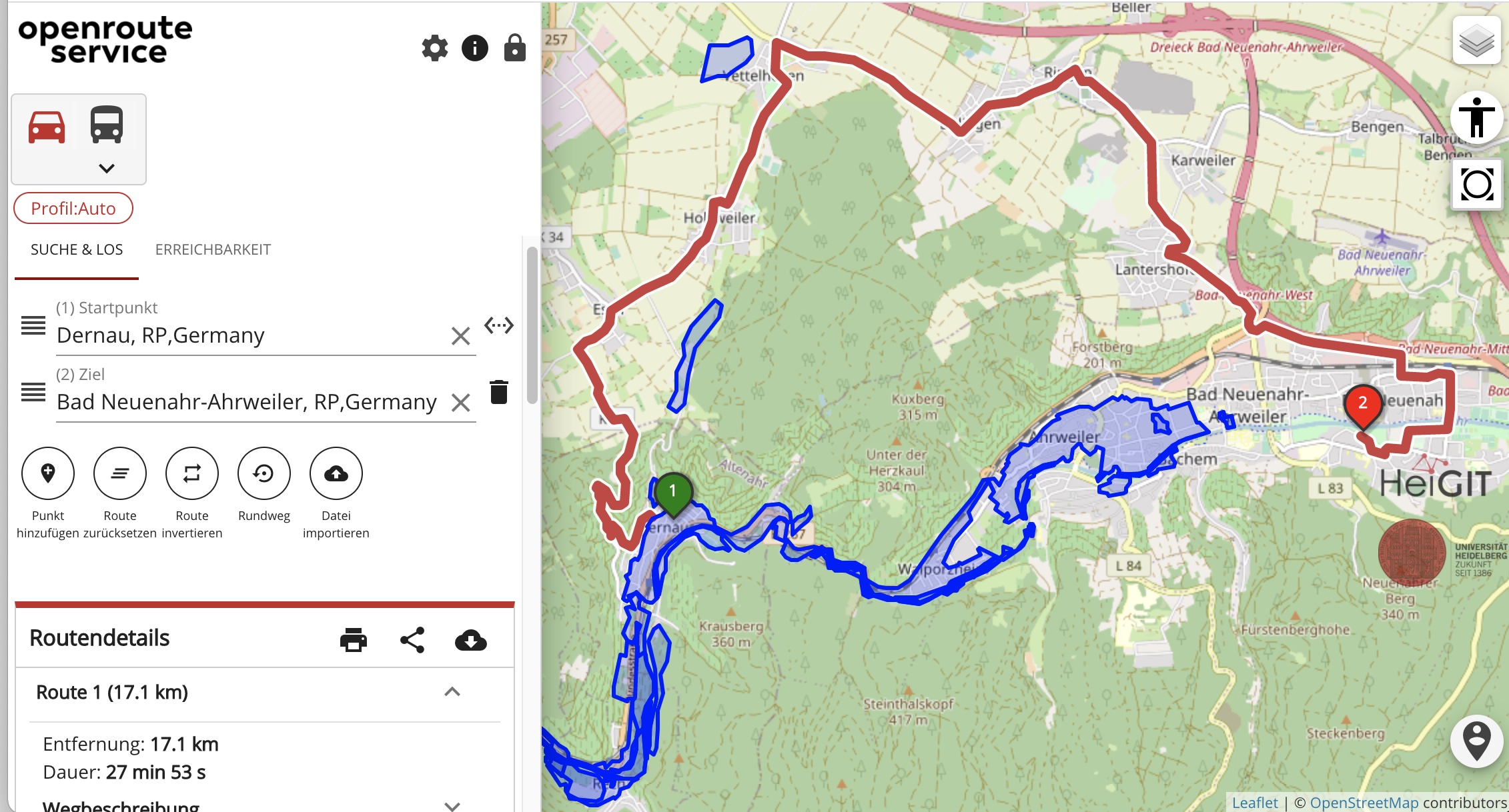
Abb: Screenshot of the new ORS service displaying the automatically bypassed flooding areas from Copernikus EMS and a calculated route
Related work (selection):
- Neis, P. & Zipf, A (2008): OpenRouteService.org is three times “Open”: Combining OpenSource, OpenLS and OpenStreetMaps. GIS Research UK (GISRUK 08). Manchester.
- Klipper, I.G., Zipf, A., Lautenbach, S., (2021): Flood Impact Assessment on Road Network and Healthcare Access at the example of Jakarta, Indonesia. AGILE: GIScience Series 2, 4, https://doi.org/10.5194/agile-giss-2-4-2021
- Ludwig, C., S. Fendrich, T. Novack, S. Marx, A. Oleś, S. Lautenbach, A. Zipf (2020): Optimal ans Ziel: Routing-Dienste auf Basis nutzergenerierter Geodaten – Herausforderungen und Lösungsansätze für globale Datensätze, In: Zagl, Loidl (Hrsg.): Geo-IT in Mobilität und Verkehr, Geoinformatik als Grundlage für moderne Verkehrsplanung und Mobilitätsmanagement. VDE Wichmann Verlag. S. 89-106.
- Eckle, M., Herfort, B., Alberquerque, R. Leiner, R. Wolff, C. Jacobs, J. P., Zipf, A. (2016): Leveraging OpenStreetMap to support flood risk management: A prototype decision support system for the identification of critical infrastructure. 13th International Conference on Information Systems for Crisis Response and Management. ISCRAM 2016. Rio de Janeiro, Brazil.
- Neis, P., Singler, P. & Zipf, A. (2010): Collaborative mapping and Emergency Routing for Disaster Logistics – Case studies from the Haiti earthquake and the UN portal for Afrika. In: Car, A., Griesebner, G. & Strobl, J. (Eds.): Geospatial Crossroads @ GI_Forum ‘10. Proceedings of the Geoinformatics Forum Salzburg.
- Schmitz, S., Neis, P. & Zipf, A. (2008): New Applications based on Collaborative Geodata – the Case of Routing. XXVIII INCA International Congress on Collaborative Mapping and SpaceTechnology, Gandhinagar, Gujarat, India.
- Schelhorn, S., Albuquerque, J.P., Zipf, A., Leiner, R. & Herfort, B. (2014): Identifying Elements at Risk from OpenStreetMap: The Case of Flooding. Proceedings of the 11th International Conference on Information Systems for Crisis Response and Management (ISCRAM) 2014, State College, Pennsylvania.
- Porto de Albuquerque, J., Eckle, M., Herfort, B. and Zipf, A. (2016): Crowdsourcing geographic information for disaster risk management and improving urban resilience: an overview of the lessons learned. In: Capineri, C, Haklay, M, Huang, H, Antoniou, V, Kettunen, J, Ostermann, F and Purves, R. (eds.) European Handbook of Crowdsourced Geographic Information, p. 325–337. London: Ubiquity Press. DOI: dx.doi.org/10.5334/bax.x
Other news (selection):
- All countries of South and Southeast Asia now on Open Healthcare Access Map
- New mFund project: start of SocialMedia2Traffic – derivation of traffic information from social media data
- A fresh new ORS maps client
- Find the route to your nearest Covid-19 vaccination center in Germany — new App by HeiGIT based on OpenStreetMap and openrouteservice
- New embedded mode for OpenRouteService map client available
- Flood Impact Assessment on Road Network and Healthcare Access at the example of Jakarta, Indonesia
- Karlsruhe relies on openrouteservice – ESRI client plugin developed
- NASA uses Openrouteservice for study on disaster response times
- OpenRouteService with waypoint optimization
- Accessibility of covid-19 vaccination centers in Germany


