Underpasses, stairs, and high curbsides are a challenge for people with impaired mobility, but these can be circumnavigated using a customized route planner for increasing mobility by calculating routes with the least amount of obstacles. This example emphasizes how geoinformation technology and geoinformatics are specifically able to help different groups of society. HeiGIT (the Heidelberg Institute for Geoinformation Technology), develops not only customizable routing options, but also supports the work of aid organizations by providing geoinformation data. This data can be used to help first responders by providing them with both a quick overview of areas affected by natural disasters (e.g. earthquakes or flooding), and routes which allow them to navigate through these areas safely.
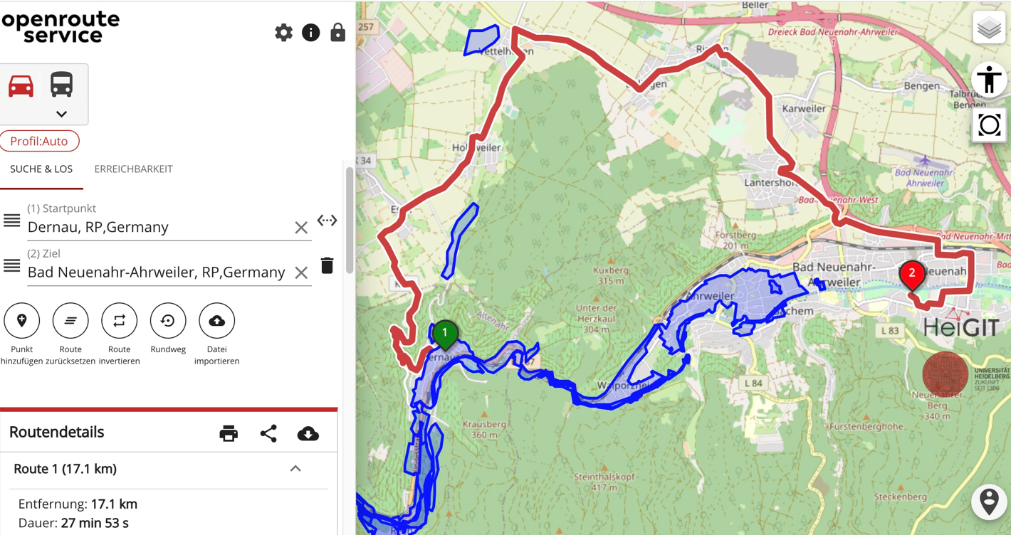
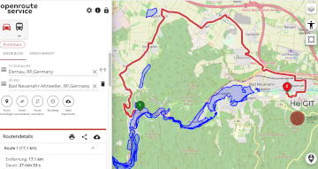
Adjusted route navigation (in red) due to the flooding in the Ahrtal region (Germany, 2021). Image: HeiGIT
To accomplish this, geodata from very large and heterogenous sources such as satellite imagery and social media data is collected and processed. Aid organizations are then able to receive near real-time digital maps created using this data that help them coordinate operations in disaster situations.
The HeiGIT institute, for which conceptualization started in 2016 and which was established in 2019, works in close cooperation with Heidelberg University and is backed by the Klaus Tschira Foundation which has recently extended and substantially expanded its funding. “We believe in the important, first-rate work HeiGIT performs and want to give the institute the necessary backing to pursue high-quality research and develop more useful applications for the benefit of society,” states Prof. Dr Carsten Könneker, Managing Director of the Klaus Tschira Foundation.
The 20+ HeiGIT employees are currently working in three core areas: smart mobility, geoinformation for humanitarian aid, and big spatial data analytics. Besides developing route planners to support customized mobility, they also harvest geodata for humanitarian aid. After an earthquake or flood, for example, first responders are able to quickly gain a geographical overview of the affected areas and determine possible deployment routes. In the third research and development area, the HeiGIT team is exploring how artificial intelligence can be used for analyzing, processing, and visualizing geodata. Through knowledge and technology transfer, the institute pursues its overarching goal of processing freely available spatial data with advanced geoinformation technology to benefit society. “HeiGIT has produced remarkable research results and has become an important incubator for technological innovation in the field of geoinformatics in the research city of Heidelberg,” affirms Prof. Dr Bernhard Eitel, Rector of Heidelberg University.
One of HeiGIT’s special accomplishments is a globally unique open source software package that analyzes the data from OpenStreetMap – a freely available and editable map – for usability and quality. “Missing geodata or data of poor or questionable quality are a problem for aid organizations in humanitarian missions, especially in the global south,” explains Alexander Zipf, professor of geoinformatics at the Institute of Geography of Heidelberg University and Director of HeiGIT. With the aid of HeiGIT’s latest development, historical mapping can be reproduced and reviewed. A variety of interfaces also renders the data compatible for web applications and other geographical analysis systems. Besides open source programming, HeiGIT also follows a citizen science approach since laypersons can also contribute to many projects.
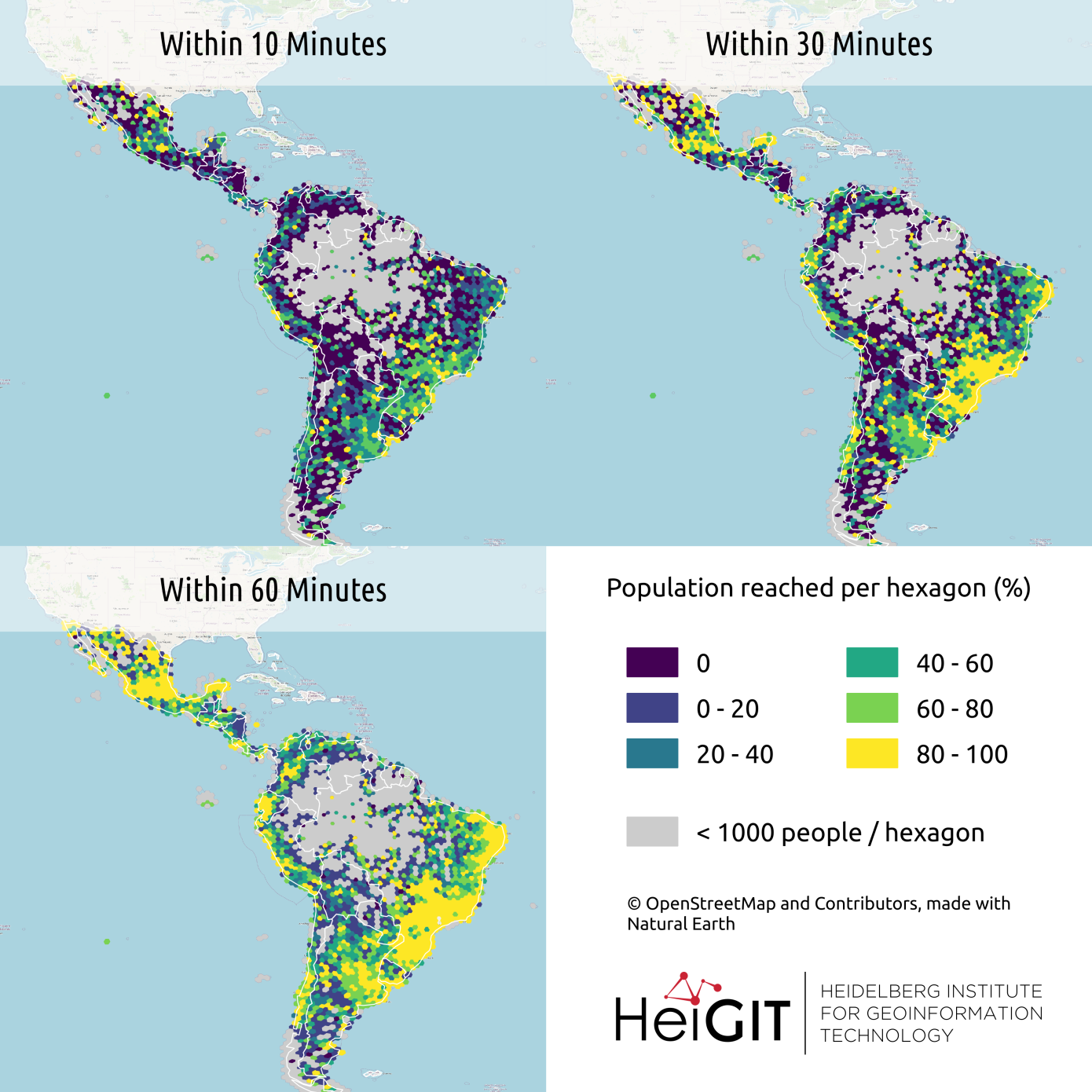
Mapping and routing application that displays access to healthcare providers. Image: HeiGIT
HeiGIT also acts internationally and maintains relations with several organizations outside of Heidelberg University (for example, the German Red Cross and Missing Maps). Two fundamental principles govern the many projects of HeiGIT: open source programming, and the citizen-science approach. Amateurs are able to participate in many projects, such as with the app “MapSwipe” (MapSwipe.org)which was co-developed by HeiGIT. With MapSwipe, anyone and everyone can contribute to close gaps in existing maps through a simple task – users mark whether they can see buildings and roads on displayed satellite images. This data is then used by experts to improve the map database. Aid organizations such as Doctors Without Borders or the Red Cross are already using the app and are ensuring that the desperately needed digital maps are available in times of emergency.
For more information, contact:
HeiGIT gGmbH (Heidelberg Institute for Geoinformation Technology)
Prof. Dr. Alexander Zipf
E-Mail: alexander.zipf@heigit.org
Klaus Tschira Foundation gGmbH
Dr. Michelle Wabnitz
Tel. 06221 533 161
E-Mail: michelle.wabnitz@klaus-tschira-stiftung.de