Large-scale mapping activities can benefit from the vastly increasing availability of earth observation (EO) data, especially when combined with volunteered geographical information (VGI) using machine learning (ML). High-resolution maps of inland surface water bodies are important for water supply and natural disaster mitigation as well as for monitoring, managing, and preserving landscapes and ecosystems.
In a recent published paper, we propose an automatic surface water mapping workflow by training a deep residual neural network (ResNet) based on OpenStreetMap (OSM) data and Sentinel-2 multispectral data, where the Simple Non-Iterative Clustering (SNIC) superpixel algorithm was employed for generating object-based training samples. As a case study, we produced an open surface water layer for Germany using a national ResNet model at a 10 m spatial resolution, which was then harmonized with OSM data for final surface water products. Moreover, we evaluated the mapping accuracy of our open water products via conducting expert validation campaigns, and comparing to existing water products, namely the WasserBLIcK and Global Surface Water Layer (GSWL). Using 4,600 validation samples in Germany, the proposed model (ResNet+SNIC) achieved an overall accuracy of 86.32% and competitive detection rates over the WasserBLIcK (87.47%) and GSWL (98.61%). This study provides comprehensive insights into how to best explore the synergy of VGI and ML of EO data in a large-scale surface water mapping task.
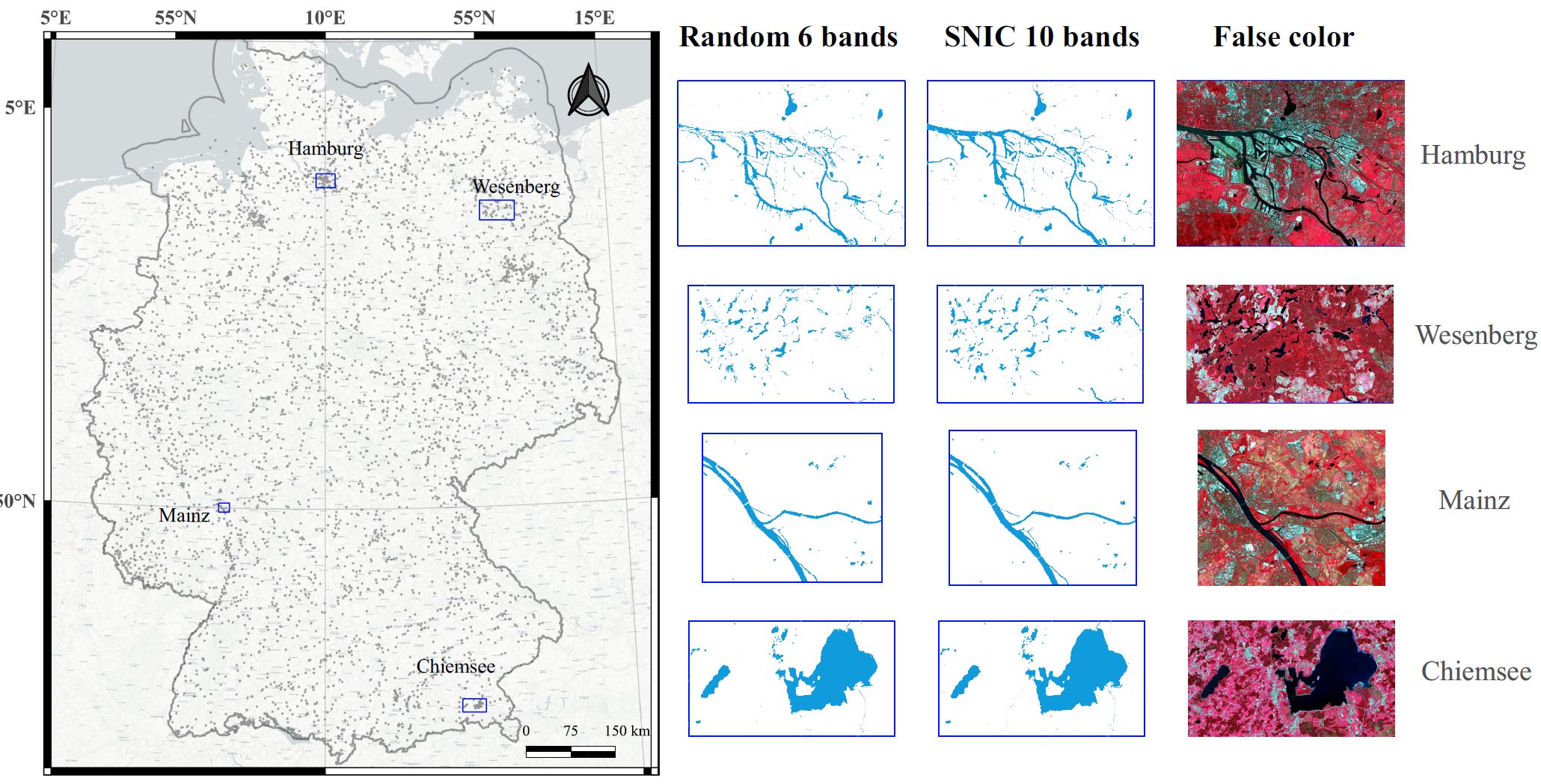
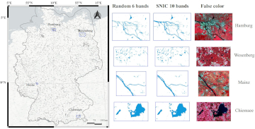
Fig: The surface water maps of four selected study areas. Left: The distribution of validation pixels and the selected study areas; Right: Predicted surface water maps using SNIC+ResNet with 10 band MSI and Random+ResNet with 6 band MSI together with the Sentinel-2 False color images.
In this recent paper published in International Journal of Applied Earth Observation and Geoinformation, we aim to emphasize the potential synergy of VGI and ML of EO data with the insights shared and lessons learned towards facilitating future large-scale and up-to-date mapping applications.
Li, H.; Zech, J.; Ludwig, C.; Fendrich, S.; Shapiro, A.; Schultz, M.; Zipf, A.(2021) Automatic mapping of national surface water with OpenStreetMap and Sentinel-2 MSI data using deep learning. International Journal of Applied Earth Observation and Geoinformation. https://doi.org/10.1016/j.jag.2021.102571
Online service and tool developed by GIScience/HeiGIT:
- The new 10meter resolution OSMlanduse.org map for the member states of the European Union.
- The ohsome API & ohsome2label python package
Previous related work at GIScience/HeiGIT (selection):
- Schultz, M., Voss, J., Auer, M., Carter, S., and Zipf, A. (2017): Open land cover from OpenStreetMap and remote sensing. International Journal of Applied Earth Observation and Geoinformation, 63, pp. 206-213. DOI: 10.1016/j.jag.2017.07.014.
- Schultz, M. (2018): Definition of citizen-observed and authoritative data collection requirements for LandSense demonstration cases. H2020 LandSense. https://doi.org/10.5281/zenodo.3670341
- Li, H.; Ghamisi, P.; Rasti, B.; Wu, Z.; Shapiro, A.; Schultz, M.; Zipf, A. A Multi-Sensor Fusion Framework Based on Coupled Residual Convolutional Neural Networks. Remote Sensing. 2020, 12, 2067. DOI: https://doi.org/10.3390/rs12122067
- Li, H., Herfort, B., Huang, W., Zia, M. and Zipf, A. (2020):
Exploration of OpenStreetMap Missing Built-up Areas using Twitter Hierarchical Clustering and Deep Learning in Mozambique. ISPRS Journal of Photogrammetry and Remote Sensing. https://doi.org/10.1016/j.isprsjprs.2020.05.007 - Wu, Zhaoyan, Li, Hao, & Zipf, Alexander. (2020). From Historical OpenStreetMap data to customized training samples for geospatial machine learning. In proceedings of the Academic Track at the State of the Map 2020 Online Conference, July 4-5 2020. DOI: http://doi.org/10.5281/zenodo.3923040
- Herfort, B., Li, H., Fendrich, S., Lautenbach, S., Zipf, A. (2019): Mapping Human Settlements with Higher Accuracy and Less Volunteer Efforts by Combining Crowdsourcing and Deep Learning. Remote Sensing 11(15), 1799. https://doi.org/10.3390/rs11151799
- Yan, Y., Schultz, M., Zipf, A. (2019): An exploratory analysis of usability of Flickr tags for land use/land cover attribution, Geo-spatial Information Science (GSIS), Taylor & Francis.
- Jokar Arsanjani, J., Helbich, M., Bakillah, M., Hagenauer,J. & Zipf, A. (2013): Toward mapping land-use patterns from volunteered geographic information. International Journal of Geographical Information Science (IJGIS). Taylor & Francis. DOI: 10.1080/13658816.2013.800871.
- Jokar Arsanjani, J., Mooney, P., Zipf, A., Schauss, A., (2015): Quality assessment of the contributed land use information from OpenStreetMap versus authoritative datasets. In: Jokar Arsanjani, J., Zipf, A., Mooney, P., Helbich, M., (eds) OpenStreetMap in GIScience: experiences, research, applications. ISBN:978-3-319-14279-1, pp. 37-51, Springer Press.
- Chen, J & Zipf, A. (2017): DeepVGI: Deep learning with volunteered geographic information. Proceedings of the 26th International Conference on World Wide Web Compagnon. Pages 771-772. https://doi.org/10.1145/3041021.3054250