A new indicator for the Lancet Countdown
In Europe, cities are center stage for climate action. With three-quarters of the continent’s population and a majority of both energy demand and greenhouse gas emissions, cities play a fundamental role in achieving Europe’s sustainable transition. The 2026 Europe Cities Report of the Lancet Countdown examines how cities across Europe are progressing towards net-zero targets and the impacts of these efforts on the health of Europe’s population. As part of the report, Danielle Gatland and Charles Hatfield, two researchers from HeiGIT, contributed a new indicator assessing how well cycling infrastructure in European cities is protected from heat by measuring tree canopy coverage along cycling infrastructure in relation to local heat stress.
Active mobility like cycling plays a critical role in reducing transport emissions while also supporting healthier lifestyles. However, as temperatures rise, heat exposure can make cycling less comfortable and, in cases of extreme heat, even unsafe. Trees along cycling routes can reduce heat exposure by providing shade and lowering air temperatures. This makes the development of urban green infrastructure, like tree shaded cycling routes, an important part of making cities climate-resilient.
Measuring tree shade along cycling routes
To investigate this, HeiGIT researchers used OpenStreetMap (OSM) data to identify cycling infrastructure and roads suitable for cycling across 885 European cities. This included dedicated cycling infrastructure as well as routes shared with pedestrians and low-speed roads shared with vehicles.
The cycling infrastructure data was then combined with high-resolution tree canopy data. A five-meter buffer was generated around all cycling paths and then intersected with the tree canopy data, to where tree canopies overlapped with cycling infrastructure. With these two datasets combined, we could then calculate the proportion of cycling infrastructure that was shaded by trees. These results were then combined with heat exposure data sourced from the Copernicus ERA5 HEAT dataset. The Copernicus ERA5-HEAT dataset provides hourly Universal Thermal Climate Index values which can be used to assess exposure to heat.
The hottest cities have the least shaded cycle paths
Across the 885 cities, mean tree canopy cover along all cycling paths was 17.2% and 30.5% along designated and shared pedestrian cycle paths. Tree canopy coverage along cycling paths was highest in western European cities (22.3%) followed by eastern Europe (19.1%), northern Europe (15.4%), southern Europe (12.3%), and then western Asia (6.6%). The above regions were selected based on the WHO European regions.
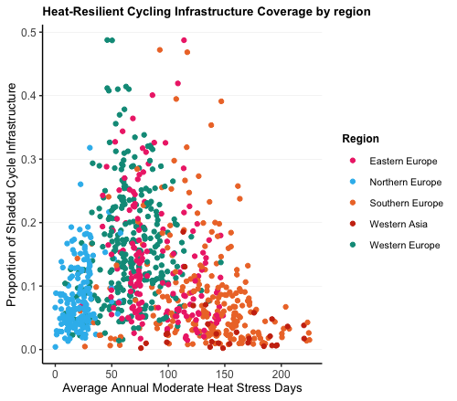
Cities with the most heat stress days had the lowest tree canopy coverage along cycling paths. Notably, 211 cities (23.8%) had moderate heat stress on more than one third of days and had an average cycle-path coverage of only 10.5%. In comparison, the 273 (30.8%) cities which had moderate heat stress less than once a week had an average cycle-path coverage of 16.7%.
These results suggest there is a mismatch between heat exposure and tree cover along cycling infrastructure in European cities, with the most heat exposed cities tending to have the least heat-resilient cycling infrastructure. This highlights an opportunity for many cities to improve climate resilience while helping to maintain safe and attractive cycling conditions as temperatures rise.
For more indicators like this one, visit HeiGIT’s Climate Action Navigator.
Reference: