HeiGIT wants to serve you even better. Therefore we are conducting user feedback surveys regarding our various services. If you have ever used one of our OpenStreetMap based Online Services (or will do so now) for whatever purpose, we’d be … Read More
Blog
AUF DIREKTEM WEG ZUR CORONA-IMPFUNG – Meldung der Universität Heidelberg
Die Universität Heidelberg berichtet aktuell über impfzentrum.openrouteservice.org NEUER ROUTENPLANER ERMITTELT DEUTSCHLANDWEIT DIE SCHNELLSTE ROUTE ZUM NÄCHSTEN IMPFZENTRUM Wo kann ich mich gegen das Coronavirus impfen lassen und wie komme ich dorthin? Diese Frage beantwortet ein von Geoinformatikern der Universität Heidelberg … Read More
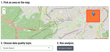
Introducing the Ohsome Quality analysT (OQT)
The Ohsome Quality analysT (short OQT) is the name of a new software implemented by HeiGIT that is based on the #ohsome framework. Its main purpose is to compute quality estimations on OpenStreetMap (OSM) data. Any end user such as … Read More
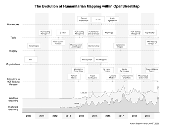
The evolution of humanitarian mapping within the OpenStreetMap community
In the past 10 years, the collaborative maps of OpenStreetMap (OSM) have been used to support humanitarian efforts around the world as well as to fill important data gaps for implementing major development frameworks such as the Sustainable Development Goals … Read More
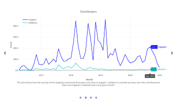
Humanitarian OSM Stats: How to monitor humanitarian mapping in the HOT Tasking Manager? – Part 2
Since 2010 organized humanitarian mapping has evolved as a constant and growing element of the global OpenStreetMap (OSM) community. With more than 7,000 projects in 150 countries humanitarian mapping has become a global community effort. Due to this large amount … Read More
German radio report on OpenStreetMap in WDR5 Quarks – Wissenschaft und mehr
The German radio station WDR 5 broadcasted a short report about OpenStreetMap with a focus on basics and navigation in the science programme “Quarks – Wissenschaft und mehr” last month on 19.01.2021. One of the German pioneers of OpenStreetMap – … Read More
Vortrag zu Humanitärem Mapping in OpenStreetMap bei Begabtenförderung des Heidelberger Life‐Science Lab
Das Heidelberger Life‐Science Lab ist eine Einrichtung des Deutschen Krebsforschungszentrums (DKFZ, Heidelberg) und hat die Förderung mathematisch und naturwissenschaftlich-technisch besonders interessierter und begabter Mittel- und Oberstufenschüler und Studenten zur Aufgabe. Der Schwerpunkt ist auf die Life-Sciences gerichtet, die den Standort … Read More
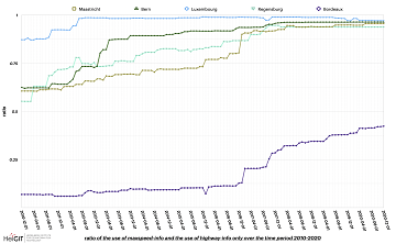
ohsome street network analysis part 2
Welcome to part 2 of the #ohsome street network analysis. If you haven’t read the first part yet, you can do so following this link. As promised, this week we are performing a simple tag completeness analysis, where we are … Read More
Humanitarian OSM Stats: How to monitor humanitarian mapping in the HOT Tasking Manager? – Part 1
Since 2010 organized humanitarian mapping has evolved as a constant and growing element of the global OpenStreetMap (OSM) community. With more than 7,000 projects in 150 countries humanitarian mapping has become a global community effort. Due to this large amount … Read More
Erstes Handbuch zur Veranstaltung von Mapathons im Deutschen Roten Kreuz
Das Handbuch zur Veranstaltung von Mapathons im Deutschen Roten Kreuz (DRK) ist da! In dem Handbuch wird beschrieben, was bei der Durchführung eines Mapathon zu beachten ist. Es beginnt mit der Frage, was überhaupt ein Mapathon ist und erklärt warum … Read More
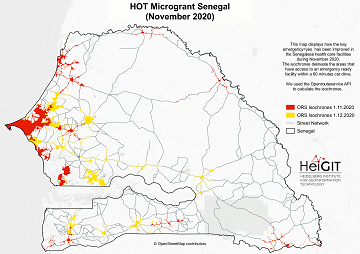
Updated OSM Healthcare in Senegal (2020)
OpenStreetMap (OSM) offers many possibilities and holds potential in the area of freely available infrastructure data for the health sector. Nevertheless, it is important to underline that the quality of the information is different in each country, since the mapping … Read More
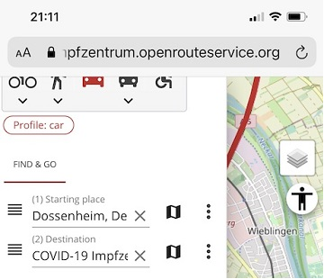
Find the route to your nearest Covid-19 vaccination center in Germany — new App by HeiGIT based on OpenStreetMap and openrouteservice
Where is is the closed Covid-19 vaccination center and what is the best way to get there? A new route planning app helps you answer this questions by suggesting ways to the nearest vaccination center. You can use this route … Read More
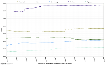
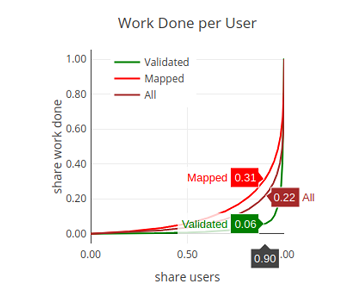
ohsome street network analysis part 1
Here we go again: The first #ohsome blog post of 2021. This time, one of our new student assistants Sarah was dealing with street networks and their quality in order to find out which of the selected regions has the … Read More
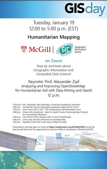
Keynote at McGILL GIS DAY: Analysing and Improving OpenStreetMap for Humanitarian Aid with Data Mining and GeoAI
Prof. Alexander Zipf has been invited to give the keynote at GIS DAY 2021 at McGILL University (Montréal, Canada) on Tuesday 19. Jan. 2021. The theme of the whole GIS Day at McGill is Humanitarian Mapping and the talk will … Read More
Update on “Accessibility of COVID-19 vaccination centers in Germany”
Based on newly available locations for missing COVID-19 vaccination centers the accessibility analysis has been updated.
Accessibility to pharmacies in Germany with 15km Covid-19 restriction
Current lockdown regulations in Germany state that – in many but not all federal states – travel in COVID-19 hotspot regions is only allowed up to 15km distance. This has raised concerns since a 15km radius has been perceived by … Read More
LandSense Horizon 2020 A Citizen Observatory and Innovation Marketplace for Land Use and Land Cover Monitoring, project successful finished
The Horizon 2020 LandSense project was concluded successful. Please find a selection of the produced publications and deliverables here. The project has enabled our group to pursue quality aspects of voluntarily collected geo information data and to ramp up efforts … Read More
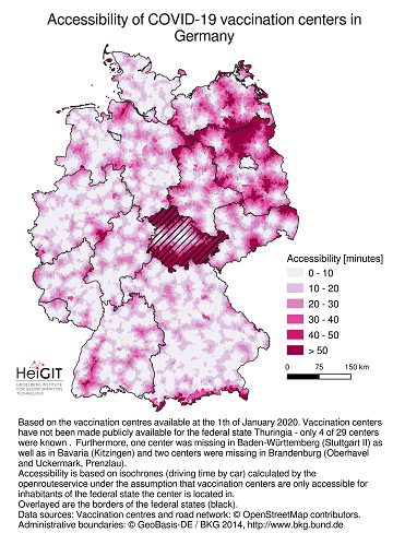
Accessibility of covid-19 vaccination centers in Germany
Vaccination of a sufficiently large share of the population is considered the most important action to fight the spread of SARS-CoV -2 and resulting COVID-19 infections. Germany has started together with the majority of EU member states at the 27th … Read More
Season’s Greetings from Heidelberg
The GIScience Research Group with the 3D Geospatial Data Processing Group and the team at HeiGIT (Heidelberg Institute for Geoinformation Technology) do send you the best wishes for a peaceful holiday season and a successful New Year. Thank you for … Read More
HeiGIT becomes a partner of the Anticipation Hub
On 8th November 2020, the Anticipation Hub has been officially launched and we are happy to announce that the Heidelberg Institute for Geoinformation Technology (HeiGIT gGmbH) acts as as a partner of the platform right from the start. The Anticipation … Read More