As summer temperatures soar, the health risks associated with heat stress become increasingly significant. This issue is particularly pronounced in urban areas such as Heidelberg and other cities, where dense building structures and limited green spaces exacerbate the problem. Vulnerable population groups such as the elderly, children and people with pre-existing conditions are especially susceptible to heat-related illnesses. In response to this challenge, the transdisciplinary project “Heat Adaptation for Vulnerable Population Groups” (HEAL) has developed climate adaptation strategies to support and protect these at-risk populations during hot weather periods.
The project brings together experts from the Heidelberg Institute for Geoinformation Technology (HeiGIT) as well as the Geoinformatics Department and the TdLab Geography (Transdisciplinarity Lab), both parts of the Institute of Geography at Heidelberg University. Funded by the Baden-Württemberg Foundation from 2021 to 2024, the project focuses on practical solutions to mitigate heat stress.
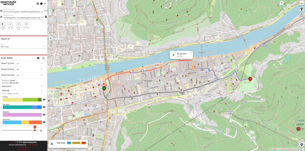
One of the key outcomes of the HEAL project is a web-based routing application designed to facilitate heat-adapted mobility. The project team identified and modeled areas with increased heat stress and developed statistical prediction models based on sensor data and existing climate analysis maps. The HEAL app calculates alternative routes that steer users away from main roads with little shade, directing them through parks and shaded areas instead. It provides detailed information about the type of path, surface and gradient along the chosen route. This tool aims to support mobility on hot days and raise awareness of the effects of climate change.
Main objective of the HEAL project is to transcend academic boundaries and address the pressing problem of heat stress in Heidelberg, emphasizing practical applications. In collaboration with the city administration and with the direct involvement of at-risk groups, the initiative enhances the knowledge base on the effects of heat on vulnerable populations. It also facilitates individual heat adaptation and supports municipal heat protection efforts. Local experts were actively engaged through accessible formats such as heat workshops with participatory methods and mobile instant messaging interviews. This approach allowed the identification of challenges and needs that might otherwise have gone unnoticed. In addition, the public will have access to information on heat adaptation strategies in the form of brochures of Heidelberg and to the HEAL app to identify routes with lower heat stress in Heidelberg.
The project team is also working on making this approach and the routing application transferable to other cities in Germany, aiming to extend the benefits of their research and innovations beyond Heidelberg.
Here you can test the HEAL app yourself.
If you have any questions or inquiries in regards to the project, feel free to send an email to heal@uni-heidelberg.de.
To learn more about the HEAL project and its impact, watch the video below (German with English subtitle):
To keep up with future developments and releases related to this project as well as other efforts to advance geospatial technology in the mobility, humanitarian aid, and data analytics space, follow the social media channels and stay up to date on our blog.


