Kooperation ist in der Humanitären Hilfe oft der Schlüssel, um Menschen in Not schnell und effizient helfen zu können. Das gilt insbesondere beim Austausch von Informationen und Kartenmaterial. Besonders herausfordernd…
Flooded parking area in Eberbach in January 2019 (Picture: C.Klonner) Worldwide, more and more people are affected by flooding. Local knowledge provides a valuable source of information for disaster risk…
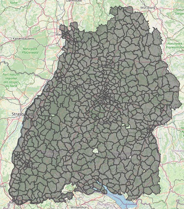
As a user‐generated map of the whole world, OpenStreetMap (OSM) provides valuable information about the natural and built environment. However, the spatial heterogeneity of the data due to cultural differences…
Ein neues Buch gibt in einem Buchkapitel einen Überblick der vielfältigen Aktivitäten von HeiGIT und GIScience im Bereich Routenplanung und Navigation. Neben Grundlagen (wie schnelle Routing-Algorithmen) zur Umsetzung werden vor…
Am am 29.10.20, 16:30 Uhr veranstaltet das Netzwerk Geoinformation der Metropolregion Rhein-Neckar GeoNet.MRN zum Thema: Flächennutzung und Flächenmanagement: Ein Geoinformation Meetup Teilnahme: Kostenlos und ohne Anmeldung mit Teams unter diesem…
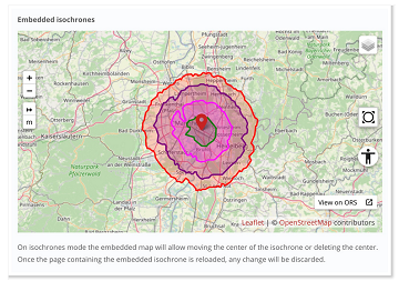
The new openrouteservice map client development is in the final phase and has now a new feature that allows to show routes, isochrones and other features from openrouteservice (ORS) integrated…
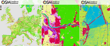
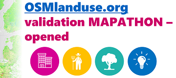
We launched a validation campaign of our new 10meter resolution OSMlanduse product for the member states of the European Union. Please contribute to the validation here. A technique where contributions…
Find here a new update of the OSMlanduse.org map. By injecting known tags provided by OpenStreetMap (OSM) into a remote sensing feature space using deep learning, tags were predicted when…
With the release of openrouteservice v6.3.0 at HeiGIT, we are presenting a new and improved speed-up technique that makes it possible to calculate much larger isochrones than with the existing…
Recently we’ve had the first minor release 1.1 of the ohsome API, which brings several new features and upgrades. In the following lines we want to present to you the…
Das Karlsruher Softwareunternehmen Disy Informationssysteme GmbH stellt die neue Version der Data-Analytics-, Reporting- und GIS-Plattform “Cadenza” vor. Die Erweiterung der Analytics-Funktionalitäten mit der Bereitstellung einer integrierten Routingfunktion und der POI-Suche…
A recently published paper provides a bibliometric review between integration of authoritative and volunteered geographic information (VGI) for the specific purpose of cartographic updating of urban mappings. The adopted methodology…
After the latest update of openrouteservice to v6.2.1, we are pleased to announce that it is now possible to calculate long distance routes using all bike and pedestrian profiles whilst…
We are pleased that our article has been selected by the editors of ISPRS Journal of Photogrammetry and Remote Sensing as the featured Article in August 2020. This means it…
#OpenStreetMap is turning 16! Happy Birthday from the HeiGIT team. After 16 years OSM is a reference of collaborative work and how we can give our best to create and…
#OpenStreetMap is turning 16! Happy Birthday from the HeiGIT team. 16 years of OSM activity has created the most feature rich and global free multi purpose map that the world…
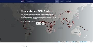
Since 2010 organized humanitarian mapping has evolved as a constant and growing element of the global OpenStreetMap (OSM) community. With more than 7,000 projects in 150 countries humanitarian mapping has…
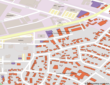
Since some time the City of Karlsruhe uses the API of Openrouteservice (ORS) by HeiGIT for routing of pedestrians, bicycles and cars in the new online city plan and the…
As you may already know from the latest blog posts, new advancements are brought with the release 1.0 of the #ohsome API. One minor function involves the correctness of parameters…