Just a couple of days ago, on December 16th, large area of the Philippines were hit by Typhoon Rai (local name Odette). The typhoon not only caused vast destruction but…
In 2020, the Humanitarian OpenStreetMap Team (HOT) received funding from seven donors through TED’s Audacious Project. This has accelerated HOT’s ambition to map an area home to one billion people….
Current COVID 19 related activities of the Humanitarian OpenStreetMap Team (HOT), Red Cross Red Crescent Climate Center and HeiGIT are featured in a blog series around Forecast-based Financing. The blog…
The Humanitarian OpenStreetMap Team (HOT) has announced major financial support from the Audacious Project, which will be provided over the next five years. HOT aims to use this funding to…
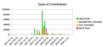
Humanitarian mapping activations show increasing numbers of contribution. This blog post illustrates the specific potential of the OSHDB API [1] for detailed analyses of such activations by means of a…
Happy Birthday Missing Maps! On the occasion of the recently launched Missing Maps 5 Years Birthday Blog, that also highlighted our latest Missing Maps related HeiGIT and ohsome projects, we…
Next week, November 12-14th, the 7th International Dialogue Platform on Forecast-based Financing is taking place in Berlin. The platform is organized by the German Red Cross (GRC), World Food Program,…
This year the bi-annual German Congress for Geography was held in Kiel in northern Germany. The conference is the main platform for German speaking researchers to exchange recent research results…
SotM Image by Thomas Skowron, licensed under CC BY 2.0 Over the last few days, Heidelberg has been host to the annual HOT Summit and State of the Map conference…
Geospatial data is key for empowering citizens around the globe and to achieve the SDGs— if geodata is made openly available and easy to be put to use. The Humanitarian…
Global Platform 2019 in Geneva Creating maps helps humanity. Drawing maps together with communities is crucial for effective risk reduction interventions, ensuring no one is left behind. The progress…
Middle of May, Geneva becomes the gathering place for citizens, political leaders, government institutions, private sector, civil society, and scientific and technical institutions, that all jointly work towards a big…
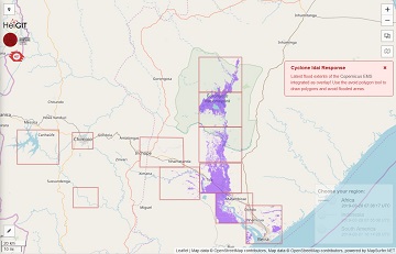
The Humanitarian OpenStreetMap Team (HOT) has launched an activation to support humanitarian operations responding to the impact of Cyclone Idai. These efforts were already supported by more than 1500 mappers…
Beginning of April, Amsterdam will become the gathering place for the global geospatial community. The Geospatial World Forum is organized for the 11th time and builds on previous successes that…
Last week, Michael Schultz (GIScience Research Group) attended the Humanitarian Technology Days 2019 that was organized by the German Aerospace Center (Deutsches Zentrum für Luft- und Raumfahrt, DLR) as a…
We are happy to hereby announce the official partnership of the HeiGIT/GIScience Research Group Heidelberg and the Humanitarian OpenStreetMap Team (HOT)! The GIScience Research Group at Heidelberg University has been…