The HeiKA autumn school urban data science that took place last week was a good success with participating students varying between five and fifteen during the week. Topics covered included visualization, spatial statistics, analysis of movement data, intrinsic data quality … Read More
English
One step forward for “25 Mapathons” – today Online Mapathon at Humanitarian Congress
The project “25 Mapathons” made an important step forward by successfully completing the first four Mapathons of the project. Two Mapathons were conducted with German Red Cross (GRC) members from the Red Cross Regional association of Westfalen-Lippe. Another two Mapathons … Read More
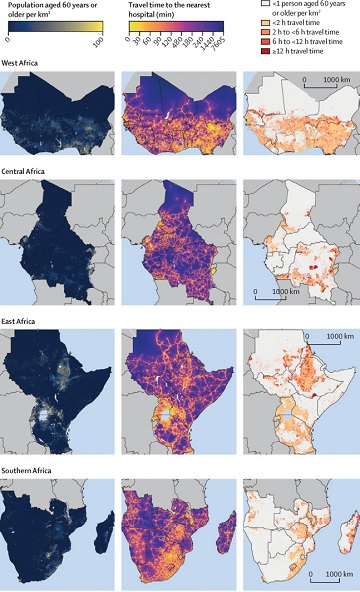
Mapping physical access to health care for older adults in sub-Saharan Africa and implications for the COVID-19 response: a cross-sectional analysis
New paper published on healthcare access in Sub-Saharan Africa It is almost a year since SARS-CoV-2 first emerged in China. The virus spread all over the world. Countries south of the Sahara did not receive much attention. Although outbreaks here … Read More
HeiGIT support for Forecast-based Financing feature around open data initiatives for anticipatory action
Current COVID 19 related activities of the Humanitarian OpenStreetMap Team (HOT), Red Cross Red Crescent Climate Center and HeiGIT are featured in a blog series around Forecast-based Financing. The blog post, “Anticipating and addressing epidemics – the potential of open … Read More
disastermappers on Tour – Mapathon im Verschwörhaus Ulm + virtuell
Über die letzten Jahre wurden von der OpenStreetMap Community in Ulm vermehrt Mapathons und Mappingaktionen veranstaltet. Am Donnerstag, den 1. Oktober 2020 ab 19:00 Uhr ist ein weiterer Mapathon des Ulmer OSM-Stammtisches geplant – mit Unterstützung von Melanie Eckle-Elze (disastermappers … Read More
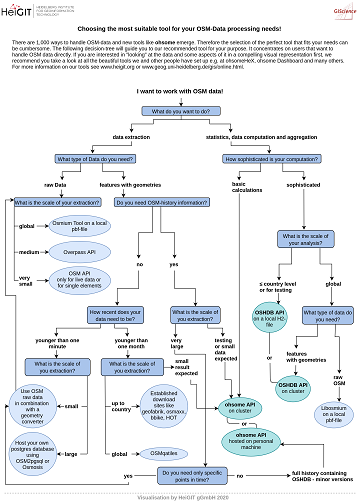
The future of working with OSM data
The open, flexible and collaborative nature as well as the benefits and advantages of OpenStreetMap (OSM) lead to the creation of a whole new ecosystem evolving around the project. They range from local and global communities of data and software … Read More
A Comprehensive Framework for Intrinsic OpenStreetMap Quality Analysis among Most Cited Paper in Transactions in GIS
We are happy to share that our paper “A Comprehensive Framework for Intrinsic OpenStreetMap Quality Analysis” (Barron, Neis, Zipf 2013) belongs to the top 5 most cited papers of the international journal “Transaction in GIS” (TGIS). Only recently we became … Read More
Setting maximum speed is back in openrouteservice
Recently openrouteservice has been updated to version 6.2 which has brought some pretty useful features to routing. One of the main “new” features is the re-introducing of the maximum_speed parameter where users can set the maximum speed their vehicle can … Read More

We wish you an ohsome birthday OpenStreetMap! Our gift: the new ohsome2X time-series tool
#OpenStreetMap is turning 16! Happy Birthday from the HeiGIT team. 16 years of OSM activity has created the most feature rich and global free multi purpose map that the world has ever seen. The ohsome team at HeiGIT has created … Read More

New function in the ohsome API for checking query parameters
As you may already know from the latest blog posts, new advancements are brought with the release 1.0 of the #ohsome API. One minor function involves the correctness of parameters that you can use in your queries, which was developed … Read More
Physische Erreichbarkeiten von Krankenhäusern in Subsahara Afrika – Analyse und Ergebnisse bei COVID-19 Symposium vorgestellt
Vom 06. bis zum 08. Juli fand das Online Symposiums “COVID-19 als Zäsur? Geographische Perspektiven auf Räume, Gesellschaften und Technologien in der Pandemie” statt. Teilnehmer aus Geographie, Medizin, Public health und meidizinischer Geographie diskutierten über drei Tage in sechs verschiedenen … Read More
How to become ohsome part 6: Introducing the magical filter parameter
We are back again with a fresh part of the How to become ohsome blog series. In case this 6th part of the series is your first one, or you have not heard from our awesome OpenStreetMap History Data Analytics … Read More

Einführung in OpenStreetMap und humanitäres Mapping bei der AGIT 2020
HeiGIT unterstützt Workshops zu OpenStreetMap und humanitärem Mapping auf der AGIT 2020 In dieser Woche findet die jährliche AGIT-Konferenz und das parallele GI Forum statt. Während die Konferenz bereits seit mehr als 30 Jahren erfolgreich Vertreter aus Wissenschaft, angewandter Forschung … Read More
Sphinx is ohsome – new documentation of the ohsome API
What does the tool behind the recently published documentation of the ohsome API have in common with a statue made of stones in Egypt? – Apart from the name, both are of course awesome (and now also ohsome). As previously … Read More
Humanitarian OpenStreetMap Team has been selected by the Audacious Project
The Humanitarian OpenStreetMap Team (HOT) has announced major financial support from the Audacious Project, which will be provided over the next five years. HOT aims to use this funding to grow OpenStreetMap (OSM) communities in 94 countries. By engaging one … Read More

Exploring OSM for healthcare access analysis in Sub-Saharan Africa
Using hospital locations and the ORS Isochrone service, we have created a method for comparing physical access to healthcare in Sub-Saharan Africa. Hospital locations were derived from OpenStreetMap and compared against another free available dataset. Results indicate strong similarity in … Read More
Going green with MeinGrün – Today App launch in Heidelberg and Dresden
Today the time has come: The “meinGrün” web app for Dresden and Heidelberg is officially launched. With the mobile application you can (re-)discover known and unknown green spaces and find a pleasant route to those. Users can learn about the … Read More
Virtual disastermappers heidelberg OSM Mapathon “Mapping Human Rights” June 30th
In scope of the disastermappers heidelberg mapathon series “Open Data & the Sustainable Development Goals”, the next virtual OpenStreetMap mapping event “Mapping Human Rights” will take place on Tuesday, June 30th from 6 pm, in cooperation with Amnesty International Heidelberg. … Read More
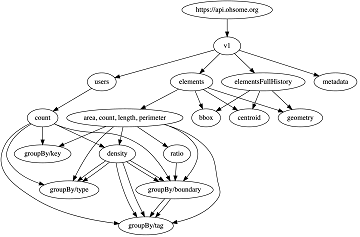
Announcing release 1.0 of ohsome API
Big news from the ohsome team: the release 1.0 of one of our major services, the ohsome API for ohsome OpenStreetMap History Analytics, is on the doorstep. We are bringing three major advancements along with this version. The first one … Read More