Das HeiGIT-Team hatte eine tolle Zeit auf der State of the Map 2022 in Florenz. Vielen Dank an die Teilnehmer für die fruchtbaren Diskussionen bei unserem Workshop! Trotz der direkten Nutzung von OSM als Karte, nutzen immer mehr Organisationen OSM … Read More
Deutsch
ohsomeHeX lite-mode: Mobile friendly ohsomeHeX
Im modernen Technologiezeitalter sind mobile Applikationen notwendig um die breite Masse zu erreichen. Deshalb ist es für jede Webanwendung kritisch über mobile Endgeräte erreichbar zu sein. Im Fall von ohsomeHeX muss, um die Nutzung auf mobilen Geräten zu ermöglichen, die … Read More
United Nations World Data Forum Blog on Healthcare Accessibility Map
In the context of the United Nations World Data Forum 2021 organised by the United Nations Statistics Division and UN member states a series of blogposts has been published by UNSTATS. Among them is one by Alexander Zipf about improving … Read More
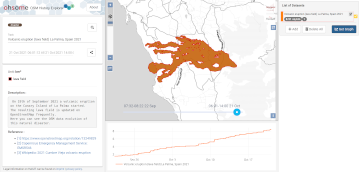
2021 Volcanic Eruption in La Palma (Spain) continues – Explore the temporal changes of the Lava Field in OpenStreetMap on ohsomeHeX
On the 19th of September 2021 a volcanic eruption on the Canary Island of La Palma started. Since then the resulting lava field is constantly growing and continues its destructive expansion. According to an article in the spanish newspaper El … Read More
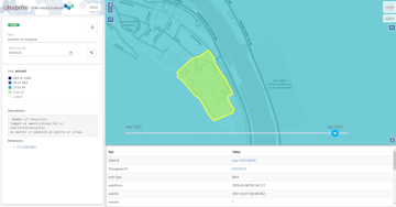
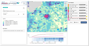
ohsomeHeX provides access to OSM feature history
Did you ever wonder how your city was mapped over time, how geometries were changed and refined, how mistakes were added and corrected again? Then read on: ohsomeHex has a great new feature for you – the individual object’s zoom-in-history-view. … Read More
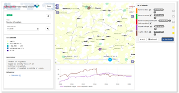
Neu: Globale OSM History Analysen mit ohsomeHeX v1.0
Erhalten Sie mit ohsomeHeX wertvolle Einblicke in die Qualität und den Entwicklungsprozess von OpenStreetMap-Daten! (see for english version here) Das HeiGIT Big Data Team freut sich zur Exploration der Veränderungen der globalen Daten in OpenStreetMap nun eine Version 1.0 von … Read More
OSM History Analysis with ohsomeHeX v1.0
Get valuable insights into the quality and development process of OpenStreetMap data with ohsomeHeX! We are proud to announce a new release that provides a completely redesigned UI that makes it easier to keep track of all relevant information. Choose … Read More
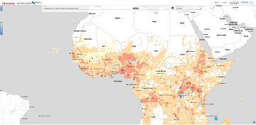
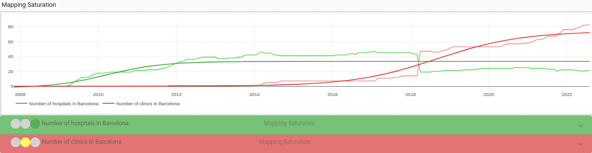
Analysing OSM Completeness of health facilities in Sub-Sahara Africa in ohsomeHeX
A new map in ohsomeHeX provides an overview of areas in Sub-Sahara Africa where information on health facilities is still missing in OpenStreetMap (OSM). The completeness of OSM is measured by comparing to a reference dataset on public health facilities … Read More