Hast du gewusst, dass man jetzt von der Taginfo-Seite von OpenStreetMap(OSM) auf das ohsome Dashboard zugreifen kann? Das ermöglicht detaillierte Einblicke in die Nutzungsstatistiken von spezifischen Keys und Tags. Taginfo ist die Hauptquelle für Statistiken über Keys, Tags und aktuelle … Read More
Deutsch
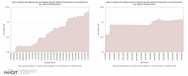
ohsome Region of the month – Temporal OSM developments in Kyiv
Willkommen zurück zu unserer ohsome Region des Monats-Serie! In diesem Post werden wir uns die zeitliche Entwicklung von Highways und hinzugefügten smoothness-information, sowie soziale Einrichtungen und neue Kartierungsentwicklungen in Kyiv anschauen. Falls die Serie für Sie neu ist, lesen Sie … Read More
Near realtime OpenStreetMap data and stats: OSHDB and ohsome API are now updated hourly
Wir haben aufregende Neuigkeiten! Wie viele von Ihnen wissen, erfolgten die OSHDB-Updates in der Vergangenheit wöchentlich und führten zu einer Verzögerung zwischen den Daten in OpenStreetMap (OSM) und unserer Datenbank. Im Grunde genommen mussten Sie bis zu einer Woche warten, … Read More
Job Offer: “Lead: Geo Machine Learning for Good”, Senior Spatial Data Science Expert (m, f, d), 100%, permanent, HeiGIT gGmbH
Du willst Deine Machine Learning Kompetenz zum Wohle der Gesellschaft und Umwelt einsetzen? Du willst die Verfügbarkeit und Qualität von Geodaten verbessern und geoinformatische Methoden weiterentwickeln, die für offene, gemeinnützige Anwendungen im Bereich Nachhaltigkeit, Mobilität und humanitäre Hilfe eingesetzt werden? … Read More
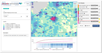
ohsomeHeX provides access to OSM feature history
Did you ever wonder how your city was mapped over time, how geometries were changed and refined, how mistakes were added and corrected again? Then read on: ohsomeHex has a great new feature for you – the individual object’s zoom-in-history-view. … Read More
OSM History Analysis with ohsomeHeX v1.0
Get valuable insights into the quality and development process of OpenStreetMap data with ohsomeHeX! We are proud to announce a new release that provides a completely redesigned UI that makes it easier to keep track of all relevant information. Choose … Read More
ohsome API v1.1 – changes and new functionalities
Recently we’ve had the first minor release 1.1 of the ohsome API, which brings several new features and upgrades. In the following lines we want to present to you the most important ones. Prior to 1.1, when you were requesting … Read More
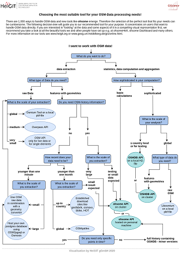
The future of working with OSM data
The open, flexible and collaborative nature as well as the benefits and advantages of OpenStreetMap (OSM) lead to the creation of a whole new ecosystem evolving around the project. They range from local and global communities of data and software … Read More

New function in the ohsome API for checking query parameters
As you may already know from the latest blog posts, new advancements are brought with the release 1.0 of the #ohsome API. One minor function involves the correctness of parameters that you can use in your queries, which was developed … Read More

How to become ohsome part 6: Introducing the magical filter parameter
We are back again with a fresh part of the How to become ohsome blog series. In case this 6th part of the series is your first one, or you have not heard from our awesome OpenStreetMap History Data Analytics … Read More
Invited talk at the Spatial Data Science Symposium 2019, Santa Barbara
The Center for Spatial Studies, Department of Geography at the University of California, Santa Barbara is hosting the Spatial Data Science Symposium 2019 this coming week with the title “Setting the Spatial Data Science Agenda” Over 40 selected participants will … Read More
GeoNet.MRN at Smart City Expo World Congress Barcelona 2019
Last week was the Smart City Expo World Congress 2019 took place in Barcelona. Our region geoinformation network GeoNet.MRN was there with a booth presenting the members of GeoNet.MRN, among others the GIScience Research Group / HeiGIT at Heidelberg University. … Read More
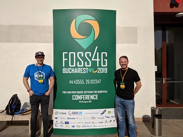
Recap of HeiGIT @ FOSS4G 2019
First of all, thanks to everybody who attended our ohsome lab at last weeks FOSS4G in Bucharest. Even though there were eleven (!) tracks running in parallel, and our lab was not in the same location as the program track, … Read More
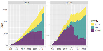
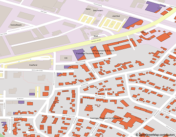
Exploring OSM history: the example of health related amenities
Introduction Exploring how OpenStreetMap data developed over time across different administrative units might reveal interesting insights into the self organizing approach of the OSM communities and can potentially be used to derive intrinsic data quality indicators. It might even be … Read More
How to become ohsome part 5: Measuring numbers of users editing different OSM features
Besides dealing with a snake, making quality assessments, or generating comparable statistics, one needs to know how to handle the whole functionality provided by the ohsome API to really become ohsome. And to achieve exactly that, this blog presents the … Read More
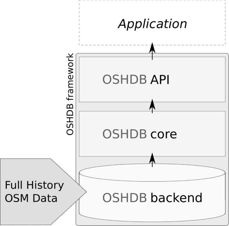
OSHDB: a framework for spatio-temporal analysis of OpenStreetMap history data
Earlier we published several blogposts introducing the ohsome platform and its parts (e.g. the ohsome API for example, which was often showcased here in the blog) and its backbone the OSHDB (very recently version 0.5 was published). A recent open … Read More
OpenStreetMap History Database – version 0.5
The OpenStreetMap History Database (OSHDB) is what powers most of the functionality of HeiGIT’s ohsome platform. The ohsome API for example, which was often showcased here in the blog, is built on top of the OSHDB. Just recently, an open … Read More
How to become ohsome part 4: handling a snake in a notebook on another planet
Welcome back to a new episode of how to become ohsome. Yes, you’ve read the heading correctly. We are really talking about a snake in a notebook on another planet. If you are familiar with one of the most used … Read More
Global analyses are ohsome
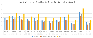
We, the Big Spatial Data Analytics Group at HeiGIT have ohsome news to share: From now on, you can send your requests to our global ohsome API instance. So far, we’ve had a public instance for Nepal and Germany, but … Read More
OpenStreetMap history explorer – ohsomeHeX published
The exploration of the history of OpenStreetMap data presents an important step to uncover semantic connections, regions of interest and their contiguity in time and space at varying scales. Therefore, the HeiGIT Big Spatial Data Analytics team presents a first … Read More