Together with collaborators from Urban Analytics Lab Singapore and CICI Lab, we are organising a special issue in Environment and Planning B: Urban Analytics and City Science, on the topic of Urban AI for a Sustainable Built Environment. Here is … Read More
Deutsch
OSM Element Vectorisation Tool Version 1
Das IDEAL-VGI Forschungsprojekt nähert sich seinem Ende. Und obwohl dies nicht das Ende unserer Forschung zu sozialen Datenquellen, Datenqualitätsanalysen und Landnutzungsinformationen sein wird, freuen wir uns, ein wichtiges Ergebnis ankündigen zu können: die Veröffentlichung der Version 1 des OSM Element … Read More
Gastvorlesungen über freiwillig zur Verfügung gestellter geografischer Informationen an der UC Chile
Im Mai 2023 besuchte Prof. Dr. Alexander Zipf gemeinsam mit Anne Schauß die UC Chile (Pontificia Universidad de Catolica de Chile) und das Heidelberg Center for Latin America (HCLA) in Santiago (Chile) und stellte in zwei öffentlichen Vorträgen vergangene und … Read More
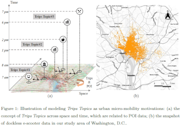
Verständnis der raumzeitlichen Reisezwecke der urbanen Mikromobilität aus der Perspektive des docklosen Teilens von E-Scootern
In den letzten zwei Jahren haben wir das immer schnellere Wachstum von Mikromobilitätsdiensten (z. B. E-Bikes und E-Scooter) miterlebt, das sowohl Herausforderungen als auch neue Möglichkeiten für die traditionellen städtischen Verkehrssysteme mit sich bringt. Beispielsweise bieten Mikromobilitätsdienste aufgrund ihres Komforts, … Read More
Räumliche Daten für die Gesellschaft – HeiGIT in die Zukunft geführt
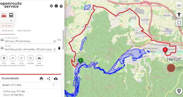
Unterführungen, Treppen und hohe Bordsteinkanten sind für Menschen mit Gehbeeinträchtigungen eine große Herausforderung. Ein maßgeschneiderter Routenplaner kann aber ihre Mobilität erhöhen, indem er Wege mit möglichst wenigen Hindernissen berechnet. Dieses Beispiel zeigt, wie Geoinformationstechnologie und Geoinformatik speziellen Gruppen in der … Read More
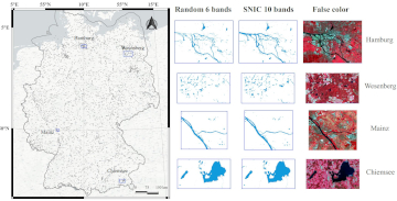
Automatic mapping of national surface water with OpenStreetMap and Sentinel-2 MSI data using deep learning
Large-scale mapping activities can benefit from the vastly increasing availability of earth observation (EO) data, especially when combined with volunteered geographical information (VGI) using machine learning (ML). High-resolution maps of inland surface water bodies are important for water supply and … Read More
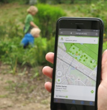
A Web App to generate and disseminate knowledge on urban green space qualities and their accessibility
Urban green spaces (UGSs) can provide important ecosystem services for citizens and their well-being. To make use of these services according to UGS user demands, urban residents, tourists, and city administrations should know where UGSs are located, what qualities they … Read More
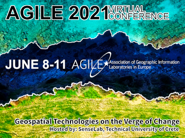
GIScience and HeiGIT contributions to AGILE 2021 conference
The AGILE 2021 conference is taking place this week. It is the the 24rd AGILE conference on GIScience. AGILE is the Association of Geographic Information Laboratories in Europe and the 2021 conference is for the first time held as a … Read More
UndercoverEisAgenten – “UndercoverEisAgenten” – Enabling Citizen Scientists to Monitor Permafrost Degradation
Die Folgen des Klimawandels sind besonders stark in den höheren Breiten unseres Planeten zu spüren. Die Arktis erwärmt sich derzeit überdurchschnittlich schnell. Dies führt zum Auftauen von Permafrost (dauerhaft gefrorenen Böden) mit ernsthaften Konsequenzen für das arktische Ökosystem. Etwa ein … Read More
New publication on the Impact of Community Happenings in OpenStreetMap
Online knowledge projects such as OpenStreetMap (OSM) and Wikipedia have gained high importance, trust and even economic value. These projects and their content are maintained and enhanced by online communities that evolve around them. Yet, these communities and their members … Read More
New paper published: Participatory Mapping and Visualization of Local Knowledge: An Example from Eberbach, Germany
Flooded parking area in Eberbach in January 2019 (Picture: C.Klonner) Worldwide, more and more people are affected by flooding. Local knowledge provides a valuable source of information for disaster risk reduction. We present an approach for visualizing and formalizing this … Read More
Integration of Authoritative and Volunteered Geographic Information for updating Urban Mapping: Challenges and Potentials
A recently published paper provides a bibliometric review between integration of authoritative and volunteered geographic information (VGI) for the specific purpose of cartographic updating of urban mappings. The adopted methodology was through a bibliometric survey of the literature published by … Read More
ISPRS IJGI highlights our work on deep learning of Street Art from VGI and Street View Images
We are pleased to share that because of the response to our work, ISPRS IJGI selected our paper on Detecting Graffiti with Street View Images and Deep Learning to be highlighted as a title story through some graphics on the … Read More
Volunteered Geographic Information research in the first decade: a narrative review of selected journal articles in GIScience
More than 10 years have passed since the coining of the term volunteered geographic information (VGI) in 2007. A recently published article presents the results of a review of the literature concerning VGI. A total of 346 articles published in … Read More
Recap: Keynote on Smart Cities
Already in October 2019 Prof. Zipf was invited to give a keynote on “User Generated Geoinformation for Smart Cities” at the “Smart Cities, Smart Data, Smart Governance” ISPRS Conference at CEPT University in Ahmedabad (known for the Gandhi-Ashram), where he … Read More
Invited talk at the Spatial Data Science Symposium 2019, Santa Barbara
The Center for Spatial Studies, Department of Geography at the University of California, Santa Barbara is hosting the Spatial Data Science Symposium 2019 this coming week with the title “Setting the Spatial Data Science Agenda” Over 40 selected participants will … Read More
2nd Call for Papers: special issue of Transactions in GIS on “Geographical and Cultural Aspects of Geo-Information – Issues and Solutions” (+ workshop proceedings are online)
Last June, colleagues from the GIScience group – Dr. Tessio Novack, Dr. Michael Schultz and Prof. Dr. Alexander Zipf – together with Dr. Peter Mooney (Maynooth University, Ireland) and Dr. Yair Grinberger (The Hebrew University in Jerusalem, Israel) have organized … Read More
Brownbag Presentation by Jennings Anderson (University of Colorado Boulder) on OpenStreetMap data analysis
We cordially invite you to a Brownbag presentation by our Guest Researcher Dr. Jennings Anderson! When? Tuesday, 8/10/2019, 1-2.30 pm Where? Seminar room 15, INF 348 Jennings is a postdoctoral researcher at the University of Colorado Boulder exploring new approaches … Read More
Do you need a shady route because it is too hot?
IT IS HOT! So you are looking for a more shady pedestrian route through the urban jungle? You might then prefer some routes that go through public green spaces with trees and bushes. Thank goodness we are working already on … Read More
Successfull PhD Defence by Clemens Jacobs on Plausibility Estimation of Citizen Science Observations for Biodiversity
Last week Dr. Clemens Jacobs successfully defended his PhD about methods for assessing the data quality of citizen science observations of organisms. Congratulations, well done!!! We wish all the very best for the future! The research aimed at using geographic … Read More