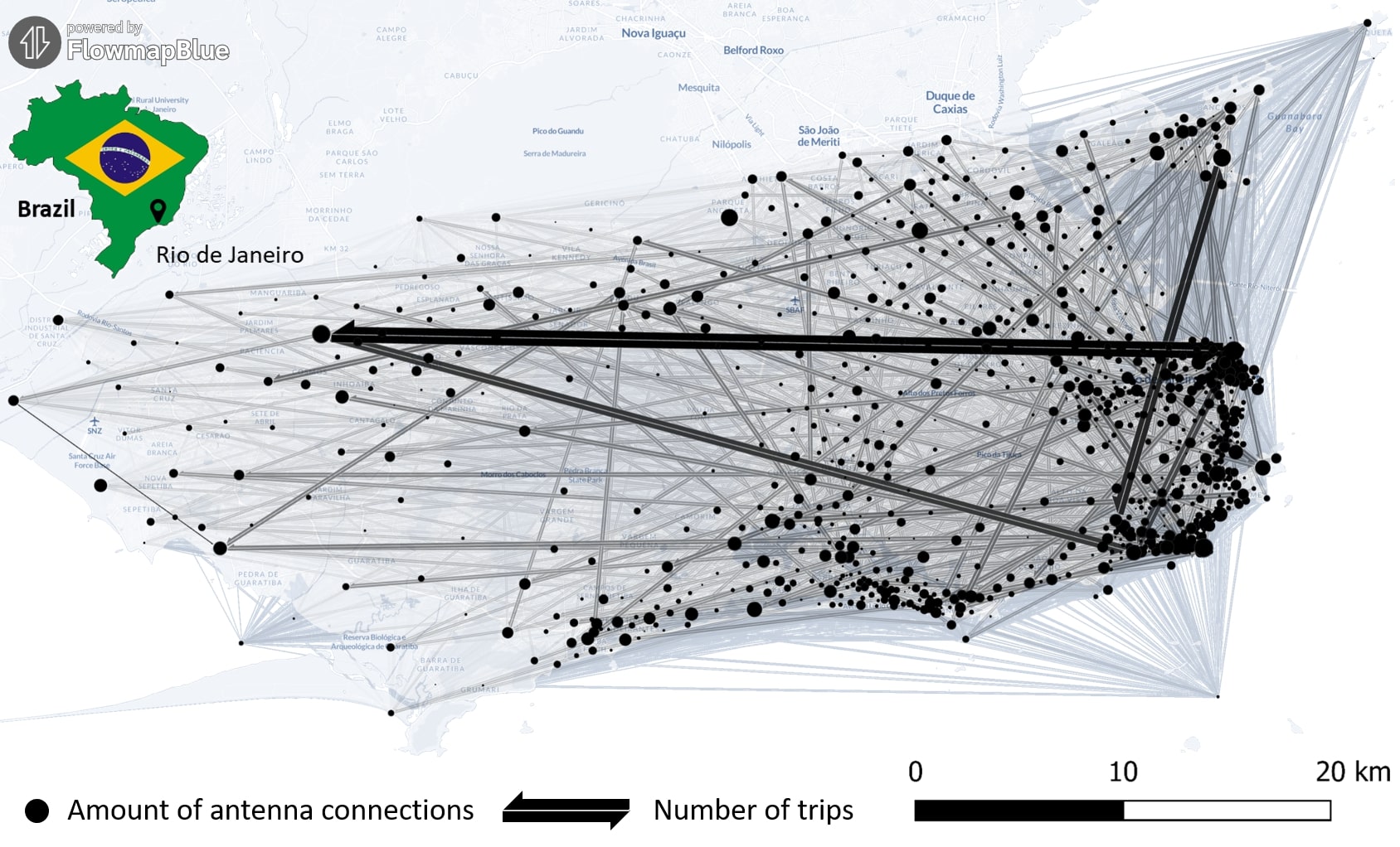
Data on mobility behavior can yield valuable insights that are beneficial for various applications such as public policy, emergency response, and urban planning. As the availability of freely-accessible mobility data is limited, the attention to X (formerly known as Twitter) … Read More
Deutsch
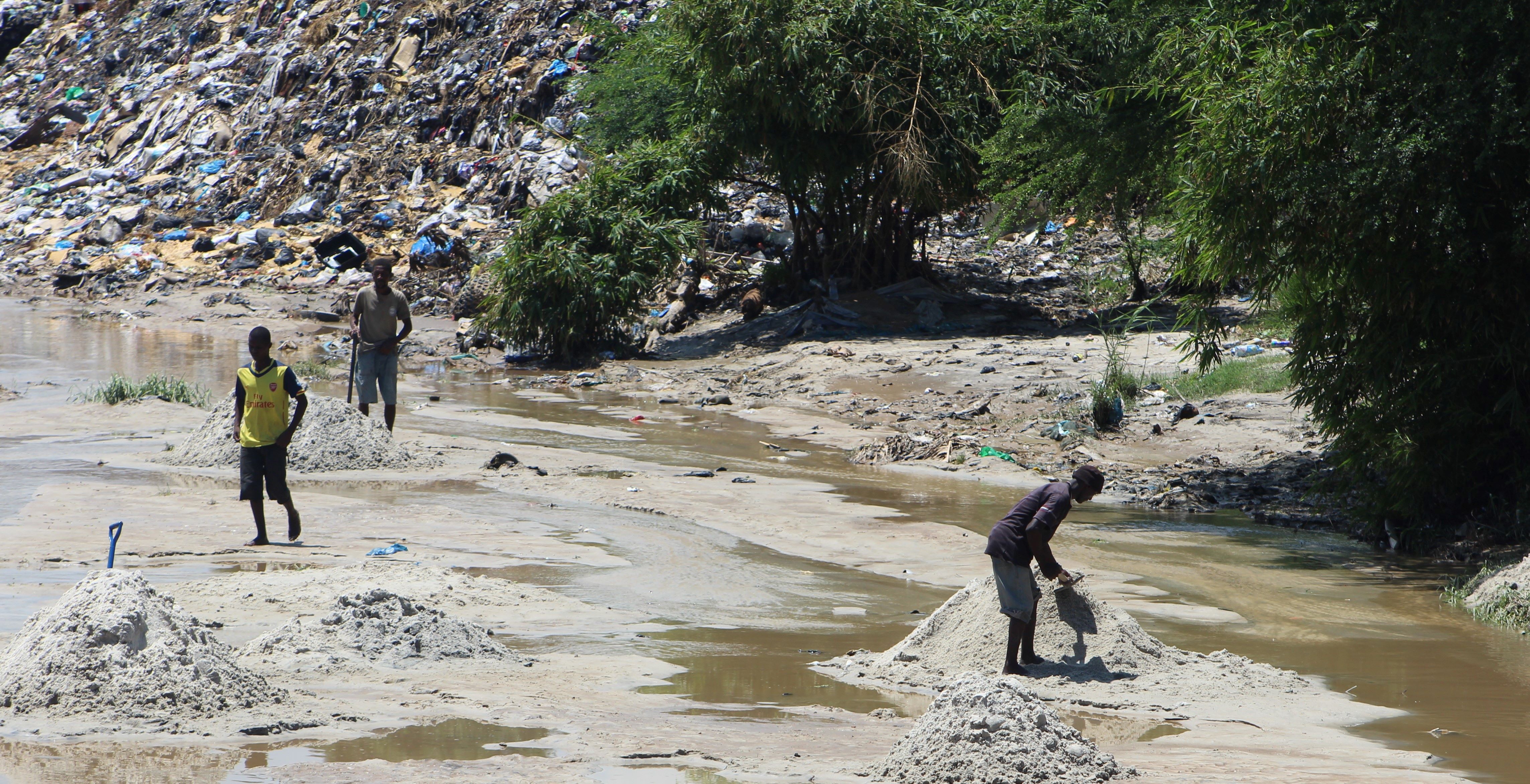
New Paper: „UAV-Assisted Municipal Solid Waste Monitoring for Informed Disposal Decisions“
Solid waste pollution is the cause of many environmental and health risks, especially in areas where waste is generated in large quantities but cannot be properly disposed of. Knowledge of the size and location of dump sites is required to … Read More
New Paper: „Enriching building function classification using Large Language Model embeddings of OpenStreetMap Tags“
Rapid global urbanization is placing immense pressure on planners to make informed decisions that promote sustainable growth. A crucial aspect of this challenge is understanding how urban buildings are used. Traditionally, classifying the function of buildings—such as residential or commercial—relies … Read More
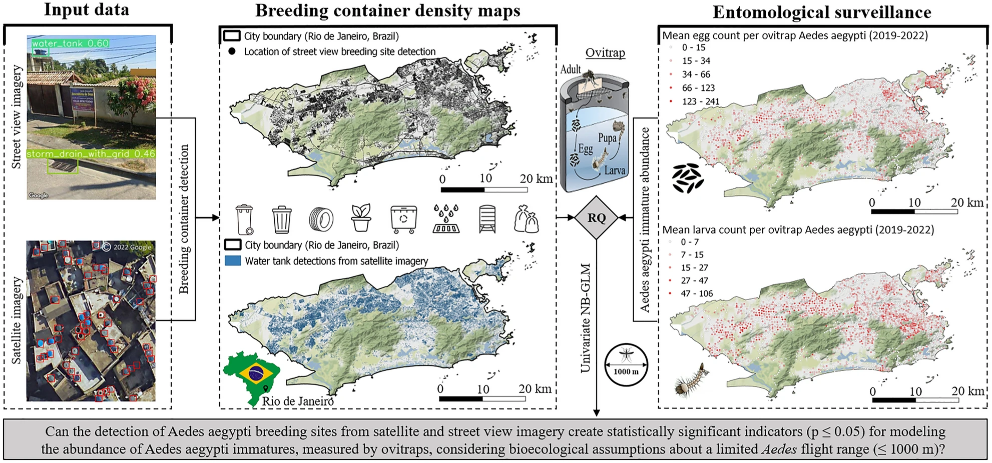
New Paper in Nature ‚Scientific Reports‘: „High-resolution Mapping of Urban Aedes Aegypti Immature Abundance Through Breeding Site Detection Based on Satellite and Street View Imagery“
Knoblauch, S; Su Yin, M.; Chatrinan, Krittin; Rocha, Antonio A. de A.; Haddawy, P.; Biljecki, F.; Lautenbach, S.; Resch, B.; Arifi, D.; Jänisch, T.; Morales, I.; and Zipf, A published the paper ‚High-resolution mapping of urban Aedes aegypti immature abundance … Read More
Call for Papers: Special Issue on Urban AI in Environment and Planning B
Together with collaborators from Urban Analytics Lab Singapore and CICI Lab, we are organising a special issue in Environment and Planning B: Urban Analytics and City Science, on the topic of Urban AI for a Sustainable Built Environment. Here is … Read More
Exploring the Value of Microsoft ML Roads for OSM Data Quality Analysis
The completeness of the OpenStreetMap (OSM) road network has been an ongoing focus for researchers for more than 15 years. For instance, Neis et al. (2011) investigated the OSM street network evolution in Germany and compared it against road data … Read More

Recap Road Quality Mapathon
Am vergangenen Montag, dem 31. Juli, veranstalteten wir einen Mapathon zum Kartieren von Straßenqualität, an dem sowohl Studierende als auch Forscher*Innen teilgenommen haben. In gemeinsamer Anstrengung wurden fast 50 % aller vorausgewählten Straßenbilder aus 34 afrikanischen Ländern klassifiziert. Diese wertvollen … Read More
Masterarbeit im Bereich Geoinformatik/Machine Learning
Das HeiGIT bietet aktuell gemeinsam mit der Gruppe GEORISK des Deutschen Zentrums für Luft- und Raumfahrttechnik (DLR-DFD-GEO) eine Masterarbeit im Kontext von Machine Learning zur Charakterisierung von Gebäudebeständen im Zusammenhang mit Naturgefahren-Risikomodellen an. Das HeiGIT ist eine gemeinnützige Organisation mit … Read More
Titel Story: Verbesserung der Erkennung fehlender Gebäude in OpenStreetMap durch Transferlernen mit wenigen Aufnahmen in sub-Saharan Afrika
Volume 26, Ausgabe 8 von Transactions in GIS, die im Dezember 2022 erschien, hat eine Titelgeschichte, und zwar einen unserer Artikel. Wir wollen darin nicht nur unsere Liebe zur Mathematik, zur Kartographie und zu Mosambik vereinen, sondern nun auch unseren kleinen … Read More
Job Offer: “Lead: Geo Machine Learning for Good”, Senior Spatial Data Science Expert (m, f, d), 100%, permanent, HeiGIT gGmbH
Du willst Deine Machine Learning Kompetenz zum Wohle der Gesellschaft und Umwelt einsetzen? Du willst die Verfügbarkeit und Qualität von Geodaten verbessern und geoinformatische Methoden weiterentwickeln, die für offene, gemeinnützige Anwendungen im Bereich Nachhaltigkeit, Mobilität und humanitäre Hilfe eingesetzt werden? … Read More

GIScience and HeiGIT contributions to AGILE 2021 conference
The AGILE 2021 conference is taking place this week. It is the the 24rd AGILE conference on GIScience. AGILE is the Association of Geographic Information Laboratories in Europe and the 2021 conference is for the first time held as a … Read More
UndercoverEisAgenten – “UndercoverEisAgenten” – Enabling Citizen Scientists to Monitor Permafrost Degradation
Die Folgen des Klimawandels sind besonders stark in den höheren Breiten unseres Planeten zu spüren. Die Arktis erwärmt sich derzeit überdurchschnittlich schnell. Dies führt zum Auftauen von Permafrost (dauerhaft gefrorenen Böden) mit ernsthaften Konsequenzen für das arktische Ökosystem. Etwa ein … Read More
geoEpi – new DFG research project on spatio-temporal epidemiology of emerging viruses
A couple of viruses are of global interest with respect to human health and well-being. These pathogens include the novel coronavirus SARS-CoV-2, Dengue, Chikungunya, Yellow fever, Zika and Ebola. These viruses show interesting spatio-temporal dynamics. Improved understanding of the driving … Read More
OSMlanduse European Union validation effort EuroSDR conference 11/24/2020
During the EuroSDR workshop we will present our OSMlanduse product (earlier post) to the land use (LU) and land cover community (LC) and highlight class accuracies and a benchmark comparison towards existing national authoritative products. Accuracy estimated to be presented … Read More

HeiKA Autumn school Urban Data Science
This week 19.-23.10. the autumn school Urban Data Science takes place as a online course set up together by GIScience Heidelberg and the Institute for Transport Studies (IfV), KIT. It is part of an ongoing application for a HeiKA (Heidelberg … Read More
OSMlanduse European Union validation effort
We launched a validation campaign of our new 10meter resolution OSMlanduse product for the member states of the European Union. Please contribute to the validation here. A technique where contributions are checked against each other is implemented to promote quality … Read More
Exploration of OpenStreetMap Missing Built-up Areas using Twitter Hierarchical Clustering and Deep Learning in Mozambique
Accurate and detailed geographical information digitizing human activity patterns plays an essential role in response to natural disasters. Volunteered geographical information, in particular OpenStreetMap (OSM), shows great potential in providing the knowledge of human settlements to support humanitarian aid, while … Read More
Recap: Keynote on Smart Cities
Already in October 2019 Prof. Zipf was invited to give a keynote on “User Generated Geoinformation for Smart Cities” at the “Smart Cities, Smart Data, Smart Governance” ISPRS Conference at CEPT University in Ahmedabad (known for the Gandhi-Ashram), where he … Read More
Invited talk at the Spatial Data Science Symposium 2019, Santa Barbara
The Center for Spatial Studies, Department of Geography at the University of California, Santa Barbara is hosting the Spatial Data Science Symposium 2019 this coming week with the title “Setting the Spatial Data Science Agenda” Over 40 selected participants will … Read More
MS Wissenschaft beendet Tour zur Künstlichen Intelligenz – aber weiter geht es im Web – auch mit unserem Exponat zu Trainingsdaten für Satellitenbilder
Gerade beendete die MS Wissenschaft ihre Tour durch 31 Städte zwischen Berlin und Wien in diesem Wissenschaftsjahr zum Thema “Künstliche Intelligenz“. 85.000 Menschen – Schulklassen, Familien und Interessierte aller Altersklassen – besuchten die Ausstellung zum Thema lernende Computersysteme an Bord … Read More