HeiGIT und das Amsterdam University Medical Center (UMC) haben sich zusammengetan, um „Food-Environments“ mit Hilfe von OpenStreetMap-Daten (OSM) zu untersuchen. Der Begriff „Food-Environments“ beschreibt die physischen, ökonomischen, politischen und sozio-kulturellen Umstände, die beeinflussen, welche Lebensmittel verfügbar sind und wie Menschen … Read More
Deutsch
OQT for Food Environments
HeiGIT and the Amsterdam University Medical Centers (UMC) partnered up to investigate food environments through the lens of OpenStreetMap (OSM) data. UMC analyses how exposure to different categories of food related retailers affects health matters. The assumption is that the … Read More
Exploring the Value of Microsoft ML Roads for OSM Data Quality Analysis
The completeness of the OpenStreetMap (OSM) road network has been an ongoing focus for researchers for more than 15 years. For instance, Neis et al. (2011) investigated the OSM street network evolution in Germany and compared it against road data … Read More
Bachelorarbeit: Nutzung von OSM für Standortanalysen von Wohnimmobilienprojekten – eine extrinsische Analyse der Datenqualität
In seiner Bachelorarbeit, betreut von apl. Prof. Dr. Sven Lautenbach am HeiGIT, untersuchte Lars Reckhaus die Eignung von OpenStreetMap (OSM) für Standortanalysen im Kontext von Wohnimmobilienprojekten. Typischerweise erfordern solche Analysen die Nutzung einer Vielzahl von Datenquellen und werden vorwiegend händisch … Read More
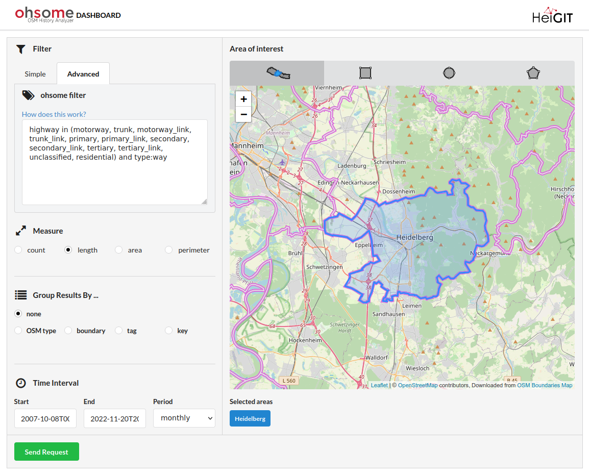
OSHDB Version 1.0 Ist Eingetroffen
Beitragsbild: Ohsome-Dashboard-Interface für Heidelberg, Deutschland. Mit den Worten von Konfuzius: „Der Mann, der einen Berg versetzt, beginnt damit, kleine Steine wegzutragen.“ Mit der Veröffentlichung der OSHDB (OpenStreetMap History Database) Version 1.0 blicken wir auf die Versionen 0.5, 0.6, 0.7 und … Read More
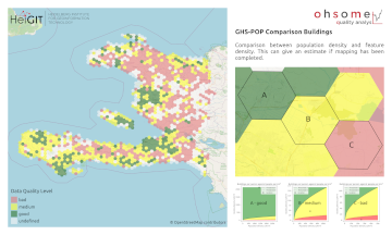
Neue Funktion im Ohsome Quality analysT: Indikator für die vollständigkeit von Gebäuden (Building Completeness Indicator)
Einführung Seit der Veröffentlichung des ohsome quality analyst (kurz OQT) im Februar letzten Jahres haben wir an der Entwicklung eines zugänglichen und dennoch leistungsfähigen Toolkits gearbeitet, das Endnutzern Einblicke in die Qualität von OpenStreetMap (OSM)-Daten bietet. Einen Überblick über die … Read More
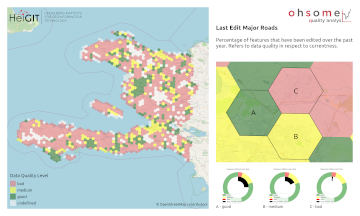
Recent feature additions to Ohsome Quality analysT
Seit der Veröffentlichung des ohsome Quality Analyst (Short OQT) im Februar letzten Jahres haben wir an der Entwicklung eines leicht zugänglichen, aber leistungsstarken Toolkits gearbeitet, das Endbenutzern Einblicke in die Qualität der OpenStreetmap-Daten (OSM) bietet. Ein Überblick über die Funktionalitätserweiterungen, … Read More
ohsome quality analyst (OQT) auf der FOSSGIS Konferenz am 09.03.22
Vom 9. bis zum 12. März 2022 findet die jährliche FOSSGIS Konferenz statt, die führende Konferenz für Freie und Open Source Software für Geoinformationssysteme und Open Data im deutschsprachigen Raum. HeiGIT wird dabei am 09.03. um 16:30–16:50 Bühne 2 ONLINE … Read More
United Nations World Data Forum Blog on Healthcare Accessibility Map
In the context of the United Nations World Data Forum 2021 organised by the United Nations Statistics Division and UN member states a series of blogposts has been published by UNSTATS. Among them is one by Alexander Zipf about improving … Read More
FOSS4G 2021 Videos with HeiGIT contributions online – OSM data quality and MapSwipe
Recently videos with our contributions by HeiGIT to the FOSS4G conference were put online. Did you miss the event? Now you can watch whenever you like 🙂 Benni by HeiGIT explains who to use the ohsome.org framework to develop an … Read More
HeiGIT and MapAction at FOSS4G 2021: Using the ohsome quality analyst to support humanitarian mapping
Last week, the annual conference FOSS4G (Free and Open Source Software for Geospatial) has been taken place online. The conference is organized by The Open Source Geospatial Foundation (OSGeo) and attracts over 1000 developers, users, decision-makers and observers from a … Read More
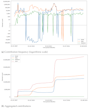
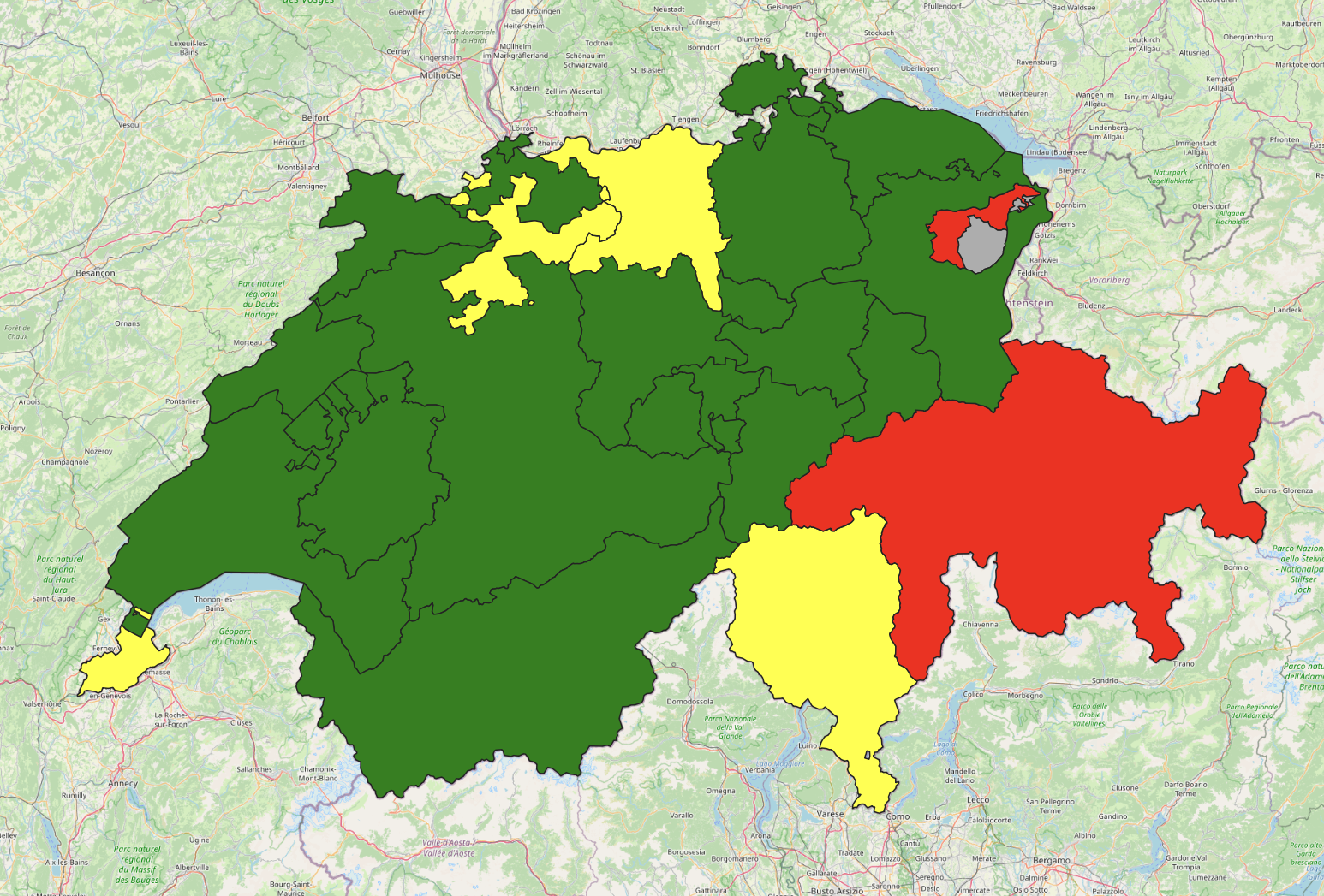
Analysing the Impact of Large Data Imports in OpenStreetMap
OpenStreetMap (OSM) is a global mapping project which generates free geographical information through a community of volunteers. OSM is used in a variety of applications and for research purposes. However, it is also possible to import external data sets to … Read More
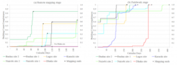
OSM data quality analysis for different stages of the mapping process
Slums are an important operational area for humanitarian organisations: Because of provisional housing, poor sanitation and difficult socio-political circumstances offers of help from such organisations are important and often necessary. For such deployments, humanitarian actors rely heavily on Volunteered Geographic … Read More
The ohsome quality analyst goes public on Github with new release 0.3.0
The ohsome quality analyst (short: OQT) has been introduced at the beginning of this year and today we are proud to announce two updates. First, we released the new version 0.3.0 which includes new OSM layers and a brand new … Read More
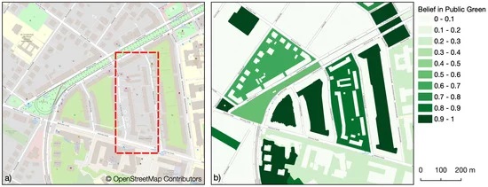
Mapping Public Urban Green Spaces Based on OpenStreetMap and Sentinel-2 Imagery Using Belief Functions
Public urban green spaces are important for the urban quality of life. Still, comprehensive open data sets on urban green spaces are not available for most cities. As open and globally available data sets, the potential of Sentinel-2 satellite imagery … Read More
Two-part Mapathons for better new user retention?
The project “25 Mapathons“ goes into the next phase. Based on the experience of until today 17 OSM mapathons with German Red Cross (GRC) chapter and an extensive literature review on the success of mapathons, the “25 Mapathons” team has … Read More
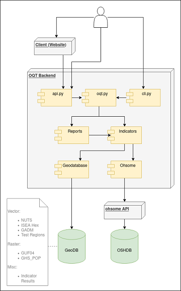
Behind the scenes of the ohsome quality analyst (OQT)
The #ohsome quality analyst (short: OQT) has been online and accessible through its web-interface now for quite some weeks already (see the introductory blog post as a reference). The website is not the only access point to the OQT though. … Read More
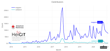
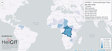
Humanitarian OSM Stats: How to monitor humanitarian mapping in the HOT Tasking Manager? – Part 5: the American Red Cross
Since 2010 organized humanitarian mapping has evolved as a constant and growing element of the global OpenStreetMap (OSM) community. With more than 8,000 projects in 150 countries humanitarian mapping has become a global community effort. Due to this large amount … Read More
Humanitarian OSM Stats: How to monitor humanitarian mapping in the HOT Tasking Manager? – Part 4
Since 2010, organized humanitarian mapping has evolved as a constant and growing element of the global OpenStreetMap (OSM) community. With more than 7,000 projects in 150 countries, humanitarian mapping has become a global community effort. Due to this large amount … Read More
Successful PhD Defense by Amin Mobasheri on OSM quality enrichment for wheelchair routing
Last Friday Amin Mobasheri of the GIScience Research Group Heidelberg University successfully defended his PhD in Geoinformatics. Due to the Corona pandemy the defense was conducted in hybrid mode with the committee members participating virtually and only Prof. Zipf and … Read More