Wir freuen uns, bekannt geben zu können, dass das IDEAL-VGI-Projekt von GIScience erfolgreich abgeschlossen wurde. IDEAL-VGI war ein Tandemprojekt in Zusammenarbeit mit Begüm Demir von der TU Berlin und wurde im Rahmen der VGIscience Second Phase Projects durchgeführt, die von … Read More
Deutsch
The Year 2023 at HeiGIT
As 2023 is coming to an end, we would like to take the opportunity to look back at this eventful year and appreciate the advance that HeiGIT has made towards its goal of enabling and improving the transfer of knowledge … Read More
Pressemeldung: Neues Tool ermöglicht Einblick in den historischen Verlauf von OpenStreetMap
Mit der OSHDB Ver. 1.0, veröffentlicht das Heidelberg Institute for Geoinformation Technology (HeiGIT) eine professionelle Software, die das Analysieren und Visualisieren der Entwicklung von OpenStreetMap Daten via eines einfachen Dashboards ermöglicht. Heidelberg, 12. Januar, 2023. Zwei Klicks. Mehr braucht es … Read More
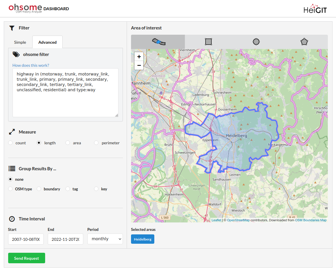
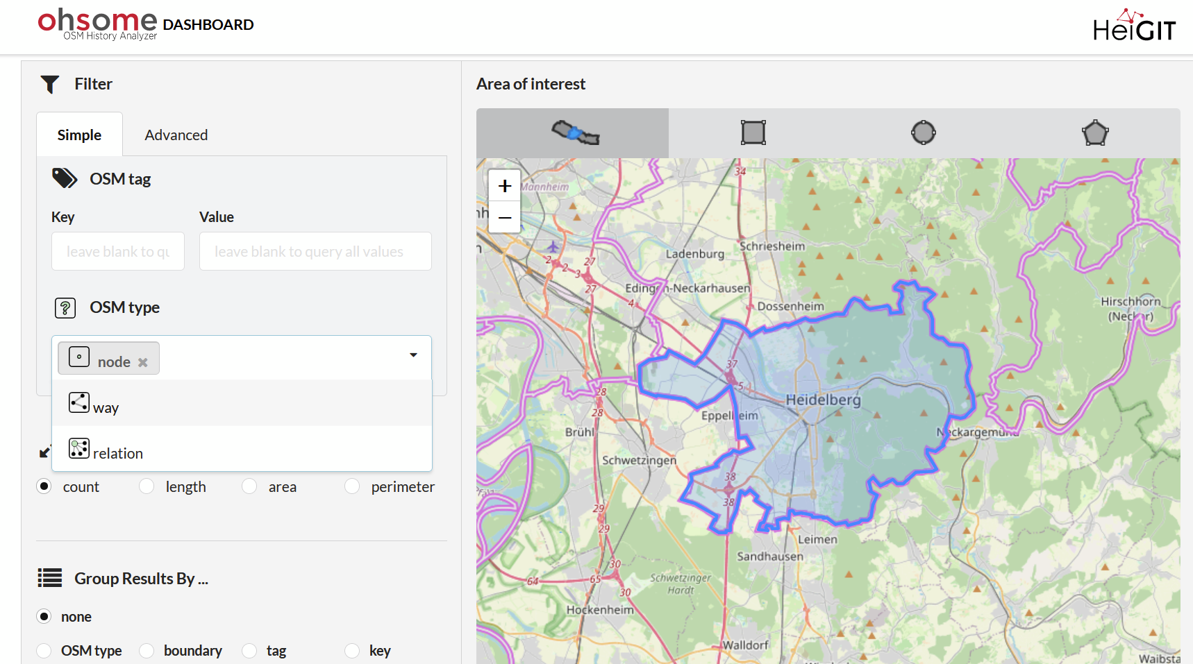
OSHDB Version 1.0 Ist Eingetroffen
Beitragsbild: Ohsome-Dashboard-Interface für Heidelberg, Deutschland. Mit den Worten von Konfuzius: „Der Mann, der einen Berg versetzt, beginnt damit, kleine Steine wegzutragen.“ Mit der Veröffentlichung der OSHDB (OpenStreetMap History Database) Version 1.0 blicken wir auf die Versionen 0.5, 0.6, 0.7 und … Read More
Exploring Localness of OSM Data – An Analysis using the OSHDB and ohsome api
“Local Knowledge” is constituting the exceptional value of Volunteered Geographical Information and thus also considered as an important indicator of data quality. We are interested in how much local information is captured in OpenStreetMap data. In this blog post we … Read More
Announcing release 1.0 of ohsome API
Big news from the ohsome team: the release 1.0 of one of our major services, the ohsome API for ohsome OpenStreetMap History Analytics, is on the doorstep. We are bringing three major advancements along with this version. The first one … Read More
Mapping Rohingya Refugee Camps in Bangladesh – An Analysis Using the OSHDB API
Humanitarian mapping activations show increasing numbers of contribution. This blog post illustrates the specific potential of the OSHDB API [1] for detailed analyses of such activations by means of a case study. The examined area is Cox’s Bazar in Southeast … Read More
Becoming ohsome is simple: Adding support of simple feature types to the ohsome API
It’s been a while, since we have published the last blog post about the awesome ohsome platform, but don’t worry, there’s always something happening of course in the spatial analytics team of HeiGIT. So here we are, back on track … Read More
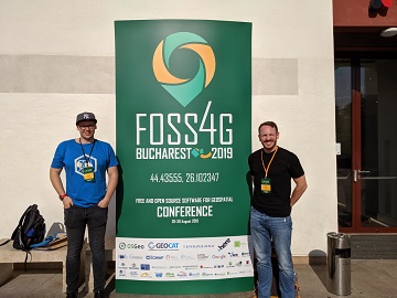
Recap of HeiGIT @ FOSS4G 2019
First of all, thanks to everybody who attended our ohsome lab at last weeks FOSS4G in Bucharest. Even though there were eleven (!) tracks running in parallel, and our lab was not in the same location as the program track, … Read More
Successfull PhD Defence by Clemens Jacobs on Plausibility Estimation of Citizen Science Observations for Biodiversity
Last week Dr. Clemens Jacobs successfully defended his PhD about methods for assessing the data quality of citizen science observations of organisms. Congratulations, well done!!! We wish all the very best for the future! The research aimed at using geographic … Read More
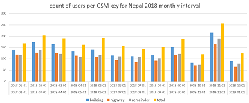
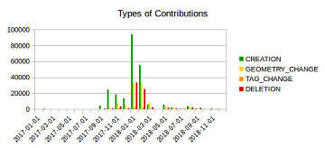
How to become ohsome part 5: Measuring numbers of users editing different OSM features
Besides dealing with a snake, making quality assessments, or generating comparable statistics, one needs to know how to handle the whole functionality provided by the ohsome API to really become ohsome. And to achieve exactly that, this blog presents the … Read More
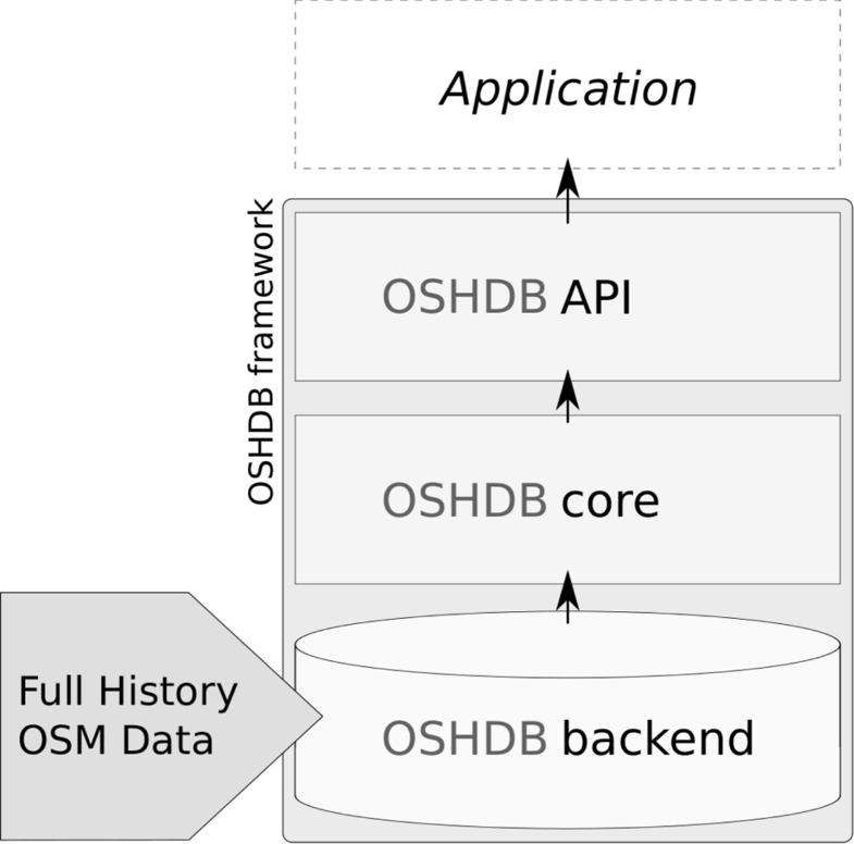
OSHDB: a framework for spatio-temporal analysis of OpenStreetMap history data
Earlier we published several blogposts introducing the ohsome platform and its parts (e.g. the ohsome API for example, which was often showcased here in the blog) and its backbone the OSHDB (very recently version 0.5 was published). A recent open … Read More
OpenStreetMap History Database – version 0.5
The OpenStreetMap History Database (OSHDB) is what powers most of the functionality of HeiGIT’s ohsome platform. The ohsome API for example, which was often showcased here in the blog, is built on top of the OSHDB. Just recently, an open … Read More
How to become ohsome part 4: handling a snake in a notebook on another planet
Welcome back to a new episode of how to become ohsome. Yes, you’ve read the heading correctly. We are really talking about a snake in a notebook on another planet. If you are familiar with one of the most used … Read More
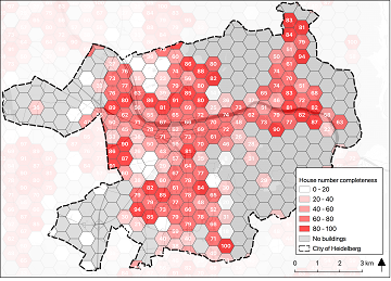
Preview: Spatial Joins using the OpenStreetMap History Database OSHDB
Max is two and loves spending Monday afternoons with his Dad at the playground. Finding a suitable playground however isn’t easy, since a few criteria must be met: there should be a bench and some trees nearby to get shelter … Read More
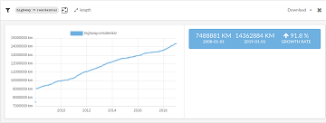
Global analyses are ohsome
We, the Big Spatial Data Analytics Group at HeiGIT have ohsome news to share: From now on, you can send your requests to our global ohsome API instance. So far, we’ve had a public instance for Nepal and Germany, but … Read More
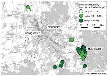
Plausible Parrots – HeiGIT’s OSHDB Supports Research in Citizen Science Data Quality
In the GIScience research group at Heidelberg University, a recent PhD research project by Clemens Jacobs has been looking into the data quality of citizen science observations of organisms. This research aims at using geographic context as an information source … Read More
How to become ohsome part 3: Identifying different mapping schemes
This is your first blog of the ohsome series? Before you might be confronted with any potential spoilers, you should better check out the first and the second part of this blog series (or the intro to the idea and … Read More
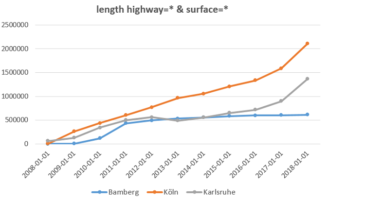
How to become ohsome part 2: Comparing different regions based on their attributive completeness of OSM data
Welcome back to the second part of the blog series how to become ohsome. If you have not read the first part yet, better go and check it out now. It explains how you can create an ohsome visualization of … Read More
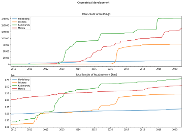
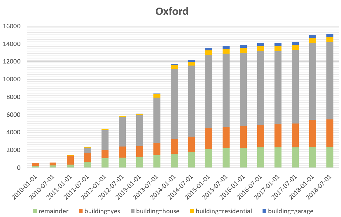
How to become ohsome part 1: Visualizing the historical evolution of OSM buildings of your city
This blog post is the start of a series of posts, which describe what you are able to do using the ohsome framework developed at the Heidelberg Institute of Geoinformation Technology (HeiGIT). OpenStreetMap (OSM), the biggest open map of our … Read More