The openrouteservice (ORS) QGIS plugin continues to evolve, bringing a suite of new features, improvements, and fixes that enhance its functionality and user experience. This update incorporates significant changes that will benefit users working on diverse geospatial projects. In this … Read More
Deutsch
ORS Tools QGIS Plugin v1.7.0 veröffentlicht
Das openrouteservice Team freut sich, pünktlich zum neuen Jahr die Veröffentlichung des ORS Tools QGIS Plugin v1.7.0 bekanntgeben zu können! Es hat sich einiges getan. Zunächst wurde das GUI überarbeitet: Manuell erstellte Punkte können nun in einer Liste gespeichert werden … Read More
Visualizing OQT API Results in QGIS
Using the ohsome dashboard, it is possible to explore quality estimation for OpenStreetMap (OSM) data from the ohsome quality analyst (OQT) for arbitrary regions. Also, OQT does provide an API to programmatically fetch quality estimation for a lot of different … Read More
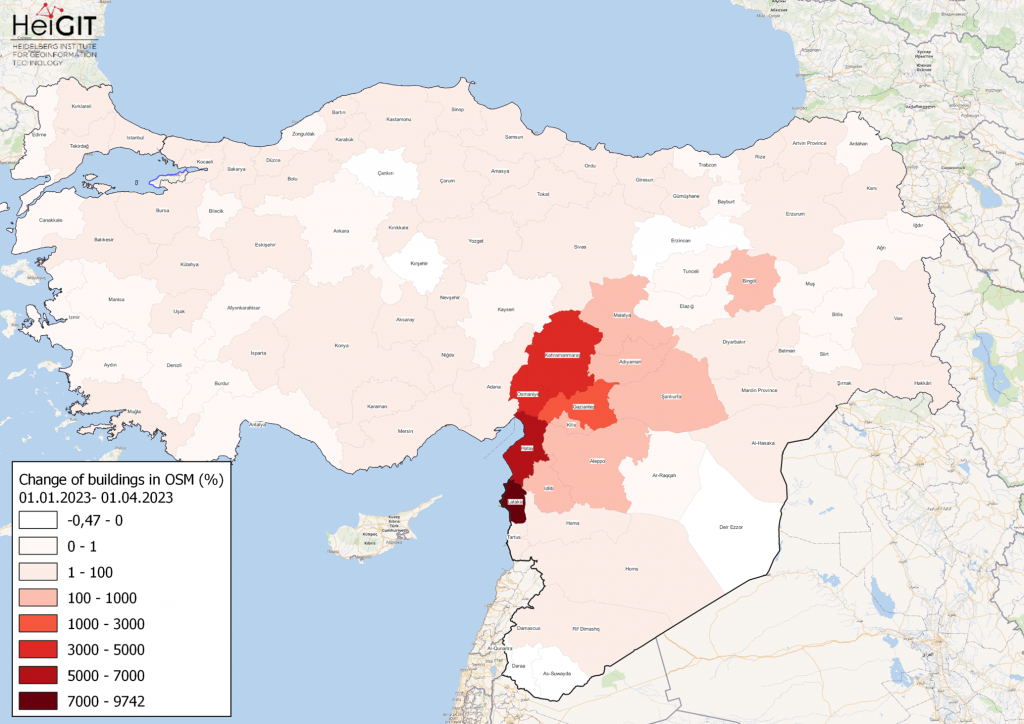
How to become ohsome part 15- Analyse von Veränderungen in OSM nach dem Erdbeben in Syrien und der Türkei im Februar 2023
Gezeigte Karte: Prozentuale Veränderung von Gebäuden in jeder Provinz der Türkei und Syriens in OSM. Daten von OpenStreetMap, visualisiert mit QGIS und dem ohsome API Plugin. Willkommen zurück zu unserer how to become ohsome- Serie! Wenn Sie neu dabei sind, schauen … Read More
HeiGIT at MSF Geo Week 2022
Diesen Juni fand die GIS-Woche 2022 von Ärzte ohne Grenzen (MSF) wieder im schönen Prag statt. Nahezu das gesamte MSF-Team, das sich mit Geodaten und Geodatenanalyse befasst, nahm an der Veranstaltung teil, die eine fantastische Gelegenheit bot, mehr über die … Read More
Openrouteservice for complex route optimization in new QGIS extension by Regionalverband Ruhr
Openrouteservice für komplexe Routenoptimierung in neuer QGIS-Erweiterung des Regionalverband Ruhr Der Regionalverband Ruhr (Team 9-2 Geodaten-Technik) hat mit einer neuen QGIS-Erweiterung das Potenzial von openrouteservice (ORS) von HeiGIT genutzt und eine weitere Anwendungsmöglichkeit für den ORS geschaffen: Das Tool “Verortung … Read More
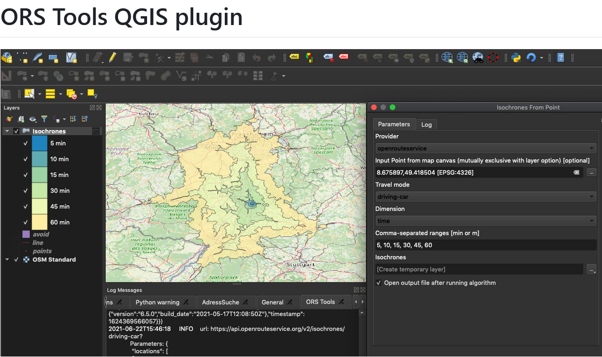
New version of ORS Tools QGIS Plugin
We’re happy to announce a new version of our QGIS Plugin ORS Tools. Additionally to the core services of giving easy access to our directions, isochrone and matrix API’s, the plugin now allows users to optimize their trips via a … Read More
New OpenRouteService QGIS Plugin
Finally there is a new version of the QGIS plugin for OpenRouteService: ORS Tools. It gives easy access to our directions, isochrone and matrix API’s from within QGIS. The old plugin OSM Tools plugin has been deprecated due to its … Read More
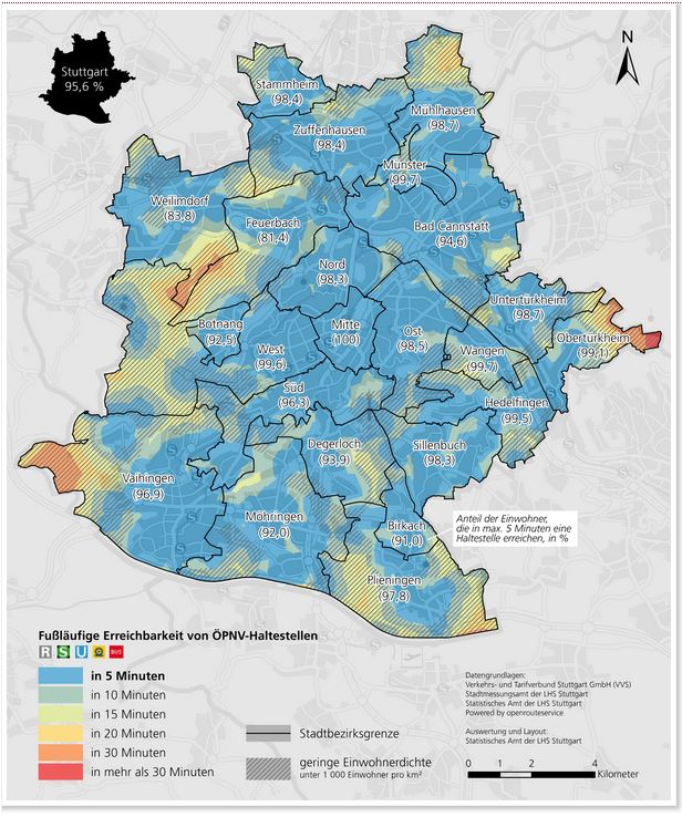
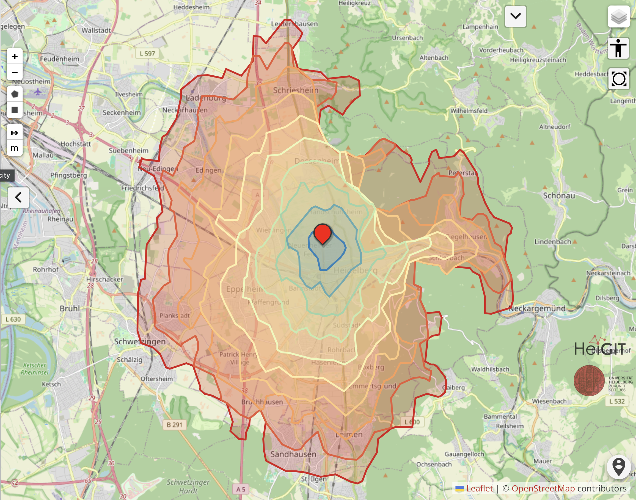
Accessibility analysis of public transport in Stuttgart
The Statistical Office of the City of Stuttgart determined the walking time to the nearest public transport stop for every place in the city using our QGIS plugin OSM Tools. With OSM Tools it only takes a few mouse clicks … Read More
How to become ohsome part 1: Visualizing the historical evolution of OSM buildings of your city
This blog post is the start of a series of posts, which describe what you are able to do using the ohsome framework developed at the Heidelberg Institute of Geoinformation Technology (HeiGIT). OpenStreetMap (OSM), the biggest open map of our … Read More