HeiGIT is celebrating its fifth anniversary today, July 1st! To commemorate this occasion, we invite you to join us on a little walk down memory lane. As we reflect on our achievements and the milestones we have reached, we want … Read More
Deutsch
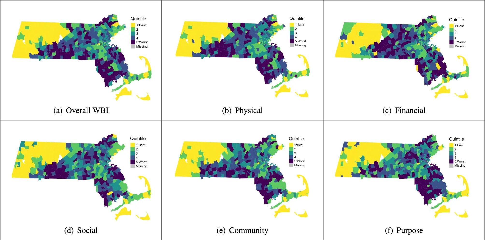
Use Case: ORS for Modeling Health and Well-Being
Open-source tools that incorporate open geospatial data, such as openrouteservice (ORS), prove to be beneficial for both academic research and practical applications. These tools enable researchers to pursue innovative approaches aimed at addressing complex societal challenges and beyond. A great … Read More
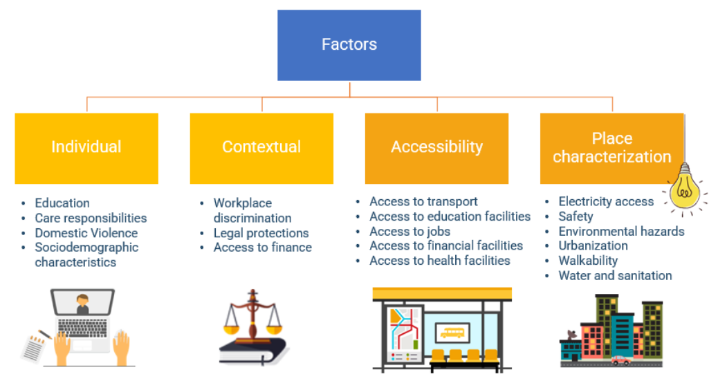
Den Wandel voranbringen: OpenRouteService in Geodaten-Initiativen für wirtschaftliches Empowerment von Frauen und nachhaltige Entwicklung
Die Nutzung von Open-Source-Geodaten erweist sich sowohl für die akademische Forschung als auch für Anwendungsfallstudien als vorteilhaft, wie Dienste wie beispielsweise openrouteservice (ORS) zeigen. Unsere Technologien haben das Potenzial, den sich stetig weiterentwickelnden Anforderungen verschiedener Sektoren zu erfüllen und gleichzeitig … Read More
HeiGITs Präsentationen bei der FOSSGIS 2024
Wir haben aufregende Neuigkeiten: Unsere Kollegen Julian Psotta und Benjamin Herfort werden Vorträge bei der FOSSGIS 2024 in Hamburg halten! Julian Psotta wird zusammen mit dem Bundesamt für Kartographie und Geodäsie (BKG) das openrouteservice Project vorstellen. In ihrem gemeinsamen Vortrag … Read More
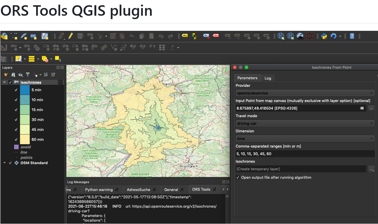
ORS Tools QGIS Plugin v1.7.0 veröffentlicht
Das openrouteservice Team freut sich, pünktlich zum neuen Jahr die Veröffentlichung des ORS Tools QGIS Plugin v1.7.0 bekanntgeben zu können! Es hat sich einiges getan. Zunächst wurde das GUI überarbeitet: Manuell erstellte Punkte können nun in einer Liste gespeichert werden … Read More

Open Source Routing und Optimierung beim Global Health Supply Chain Summit 2023
Julian Psotta, HeiGIT Produkct Manager für Smart Mobility, nahm am diesjährigen Global Health Supply Chain Summit in Nairobi, Kenia, teil. Unter dem Hauptthema “Sustainable and Resilient Supply Chains for Equitable Access to Healthcare” (Nachhaltige und widerstandsfähige Versorgungsketten für einen gerechten … Read More
HeiGITs Disaster Portal in Radiobeitrag vorgestellt
Campusreporter Nils Birschmann hat mit Prof. Alexander Zipf über unser Disaster Portal gesprochen. Das Interview wurde über Radio Regenbogen ausgestrahlt. Hier könnt ihr euch den Beitrag in voller Länge anhören: Audiobeitrag: Das Disaster Portal – sichere und schnell verfügbare Datengrundlagen … Read More
Looking back at FOSS4G Conference 2023
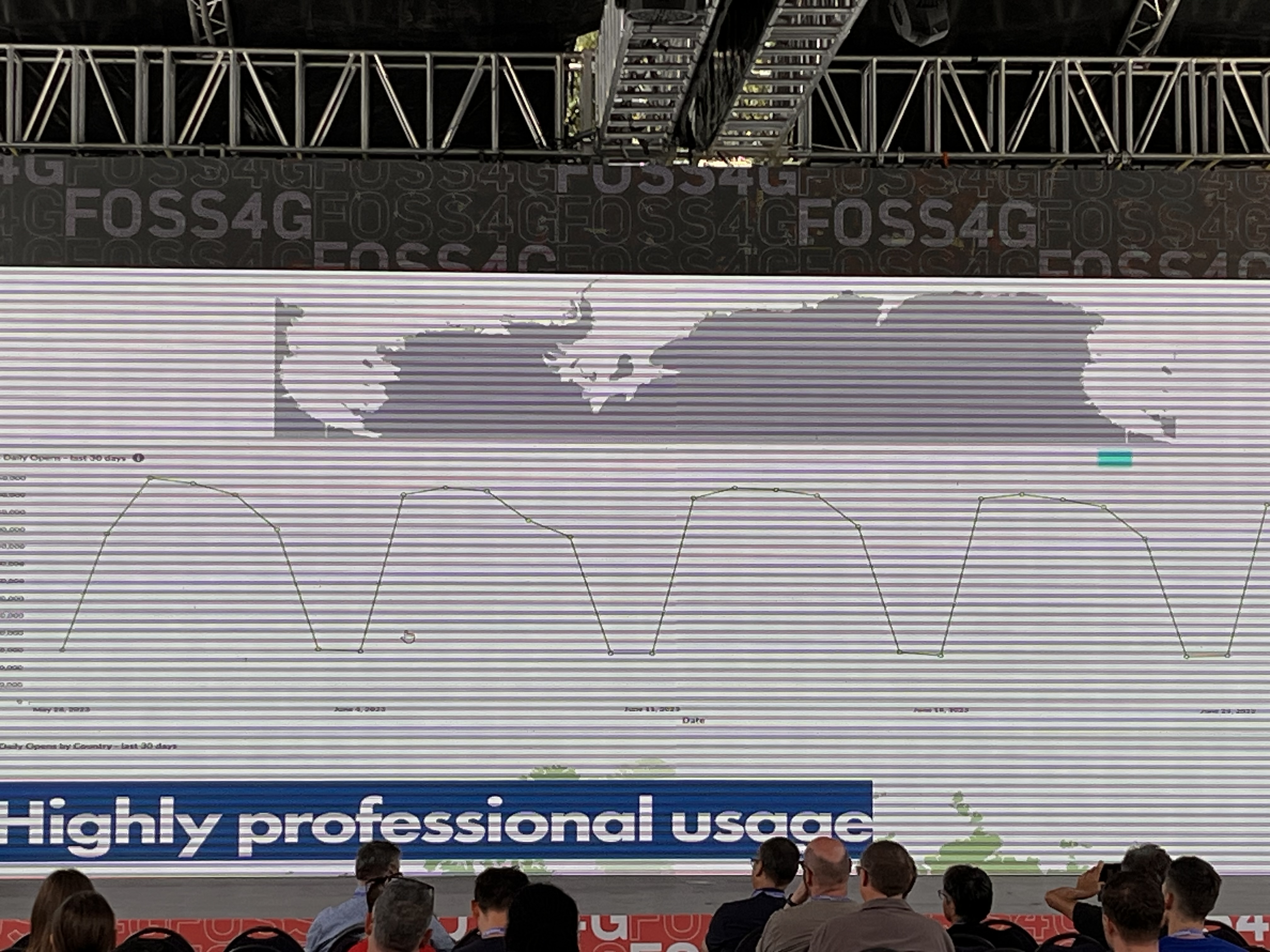
Abbildung 1: FOSS4G 2023, QGIS tägliche Öffnungen Die diesjährige FOSS4G Konferenz fand vom 26. Juni bis zum 2. Juli 2023 im schönen Prizren, Kosovo, statt. Seit 2006 wird FOSS4G, die größte globale Zusammenkunft für geospatial Software, vom Open Source … Read More
Revamped openrouteservice client for disaster management
We are happy to announce a revamped openrouteservice maps client for disaster management. It was built based on the new openrouteservice maps client, that is an open source route planner with plenty of features. Specific disaster features were incorporated via … Read More

Auf sicherem Weg durch die Hitze: Transdisziplinäres Projekt HEAL erleichtert den Alltag für Risikogruppen
Im Rahmen einer transdisziplinären Zusammenarbeit entwickeln das Heidelberg Institute for Geoinformation Technology (HeiGIT), die GIScience Forschungsgruppe sowie das TdLab Geographie der Universität Heidelberg gemeinsam Anpassungsstrategien, die Risikogruppen während Hitzeperioden unterstützen und schützen sollen. Individuelle Bedürfnisse hitzesensitiver Personen und Nahe-Echtzeit-Sensordaten werden … Read More
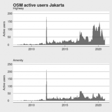
Becoming ohsome in R – analysis of the completeness of the road network and health sites in Jakarta
Data quality is an important issue then performing analysis based on OpenStreetMap data. We have recently demonstrated how the effects of the 2013 flood in Jakarta on the accessibility of hospitals and clinics could be analyzed based on network analysis … Read More
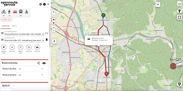
A fresh new ORS maps client
We are happy to announce that the new openrouteservice maps client has been finished and released. It is an open source route planner with plenty of features for car, heavy vehicles, hiking, cycling and wheelchair, designed to be mobile friendly … Read More
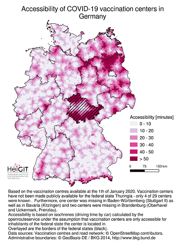
Accessibility of covid-19 vaccination centers in Germany
Vaccination of a sufficiently large share of the population is considered the most important action to fight the spread of SARS-CoV -2 and resulting COVID-19 infections. Germany has started together with the majority of EU member states at the 27th … Read More
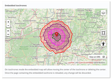
New embedded mode for OpenRouteService map client available
The new openrouteservice map client development is in the final phase and has now a new feature that allows to show routes, isochrones and other features from openrouteservice (ORS) integrated on other websites. This allows webmasters and editors to embed … Read More
A revamped ORS map client to celebrate the 16th OpenStreetMap anniversary
#OpenStreetMap is turning 16! Happy Birthday from the HeiGIT team. After 16 years OSM is a reference of collaborative work and how we can give our best to create and maintain global, free and multipurpose projects that bring benefits to … Read More
Advanced time-dependent routing soon available in Openrouteservice
We are thrilled to give you a sneak peak into routing with time-dependent road restrictions, the outcome of our collaboration with GraphHopper GmbH in the research project TARDUR supported by the mFUND initiative of the Federal Ministry of Transport and … Read More

Einladung zum Beta Test der meinGrün App
Beim Konsortialtreffen letzte Woche haben wir die erste Beta Version der meinGrün App fertiggestellt. Jetzt benötigen wir Grünflächen-Enthusiasten, die mit uns zusammen die App testen, um sie weiter zu verbessern. Diesen Samstag findet unser erstes Test-Event statt: WO: Volkshochschule Heidelberg … Read More

New OpenRouteService API playground
After the release of the new OpenRouteService dashboard the team has worked on a new interactive API documentation application named API Playground , that allows the users to explore all the OpenRouteService API services, parameters and responses in an intuitive … Read More
Openrouteservice Developers Dashboard Revamped
Over the past few months the openrouteservice team has worked on a new developers dashboard in order to make the registration and usage of the API more easy and accessible. Now the developers using the openrouteservice API will experience a … Read More