HeiGIT is celebrating its fifth anniversary today, July 1st! To commemorate this occasion, we invite you to join us on a little walk down memory lane. As we reflect on our achievements and the milestones we have reached, we want … Read More
Deutsch

Die neue MapSwipe Web App ist da!
Ab jetzt kannst du mit der MapSwipe Web App von deinem Browser aus weltweit helfen und einen Unterschied machen! Seit 2015 nutzt MapSwipe die kollektive Stärke von Freiwilligen, um aktiv zu Geodatenprojekten beizutragen. Frei zugängliche Geodaten spielen eine zunehmend große … Read More
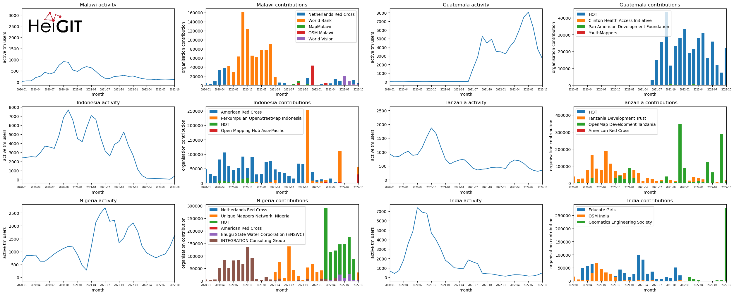
Analysis of Humanitarian OSM Stats: User activity through HOT-TM and contributing organizations
Introduction In this blogpost we are taking a look at humanitarian mapping through the Tasking Manager (HOT-TM) that is operated by the Humanitarian OpenStreetMap Team (HOT). At HeiGIT we work together with HOT to provide analyses and statistics to further … Read More
Monitoring OSM and Tasking Manager to Map 1 Billion
In 2020, the Humanitarian OpenStreetMap Team (HOT) received funding from seven donors through TED’s Audacious Project. This has accelerated HOT’s ambition to map an area home to one billion people. HOT is working to add places at high risk of … Read More
Disastermappers Heidelberg International Mapathon on December 8th
On December 8th at 6.30 pm the next international mapathon organized by the disastermappers heidelberg takes place! This time we map together with MAMAPA, an integration project for migrants and refugees from Mannheim, CartONG, LECLARA Larabanga and OSM Ghana. We … Read More
HeiGIT participates at virtual HOT Summit 2020
Next week the HOT Summit will take place. The conference takes already place for the sixth time and it is the fifth consecutive time that we from HeiGIT/GIScience Heidelberg do contribute a session. This years topic is 10 Years of … Read More
One step forward for “25 Mapathons” – today Online Mapathon at Humanitarian Congress
The project “25 Mapathons” made an important step forward by successfully completing the first four Mapathons of the project. Two Mapathons were conducted with German Red Cross (GRC) members from the Red Cross Regional association of Westfalen-Lippe. Another two Mapathons … Read More
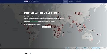
Introducing the humstats.heigit.org dashboard about Humanitarian Mapping in OpenStreetMap
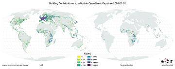
Since 2010 organized humanitarian mapping has evolved as a constant and growing element of the global OpenStreetMap (OSM) community. With more than 7,000 projects in 150 countries humanitarian mapping has become a global community effort. Mappers have added more than … Read More

MapSwipe wins Global Mobile Award for the Best Mobile Innovation Supporting Emergency or Humanitarian Situations
This week, at the prestigious GSMA MWC series (formally known as Mobile World Congress) MapSwipe was awarded the top prize in the Global Mobile Awards’ category for the Best Mobile Innovation Supporting Emergency or Humanitarian Situations. The award recognizes how … Read More
Marcel Reinmuth: Talk about internship at Humanitarian OpenStreetMap Team Uganda
GIScience HD/HeiGIT sind seit geraumer Zeit Partner des Humanitarian Open StreetMap Team (HOT) und arbeiten an gemeinsamen Projekten zur Verbesserung von Geoinformationstechnologien und der Verfügbarkeit von Geodaten (insb. OpenStreetMap) für humanitäre Einsätze, insbesondere im globalen Süden, z.B. über die Missing … Read More
Standortübergreifender Mapathon im Rahmen der Geography Awareness Week
im Rahmen der Geography Awareness Week laden die Geographie-Fachschaften der Standorte Göttingen, Hannover, Würzburg und Heidelberg und die disastermappers heidelberg herzlich zum standortübergreifenden Mapathon ein! An diesem Mapathon werden wir gemeinschaftlich mit Hilfe von OpenStreetMap und fernerkundlichen Methoden neue Kartendaten … Read More
Tools for Disaster Risk Reduction by HeiGIT – Celebrating the International Day for Disaster Risk Reduction
Today we celebrate the International Day for #DisasterRiskReduction. HeiGIT offers a growing set of tools and services that support humanitarian aid during and before disasters. Examples include work in the context of the Missing Maps initiative, like conceptualising and extending … Read More
OpenStreetMap (OSM) Workshop at the University of Jena
Last week, GIScience Heidelberg successfully held two collaborative workshops about OpenStreetMap (OSM) at the Department of Earth Observation in Jena. Dr. Chistian Thiel and his team from the University of Jena kindly organized the event. Three members of the GIScience … Read More
MapSwipe for Change Detection Analysis
The Humanitarian OpenStreetMap Team (HOT) , the Heidelberg Institute of Geoinformation Technology (HeiGIT) , and the wider MapSwipe Community started working on an MapSwipe extension to monitor changes in satellite imagery. The goal of the two-month project is to extend … Read More
GIScience / HeiGIT at ICT for Development, Kampala – Usage and Analyses of OpenStreetMap for Development
The 11th Information Communications Technology for Development (ICT4D) Conference brings together hundreds of public, private and civil society organizations, eager to share practical insights on applying digital technology to development, humanitarian, and conservation challenges. Participants share how they are using … Read More
OpenStreetMap Analytics Development for OpenCities Africa
Recently a consultancy and development agreement about OpenStreetMap Analytics Development has been reached with the World Bank in the context of the Open Cities Africa project and the Global Facility for Disaster Reduction and Recovery (GFDRR) Open Data for Resilience … Read More
HeiGIT/GIScience Heidelberg partnership with Humanitarian OpenStreetMap Team (HOT)
We are happy to hereby announce the official partnership of the HeiGIT/GIScience Research Group Heidelberg and the Humanitarian OpenStreetMap Team (HOT)! The GIScience Research Group at Heidelberg University has been supporting the use of OpenStreetMap for humanitarian and disaster management … Read More