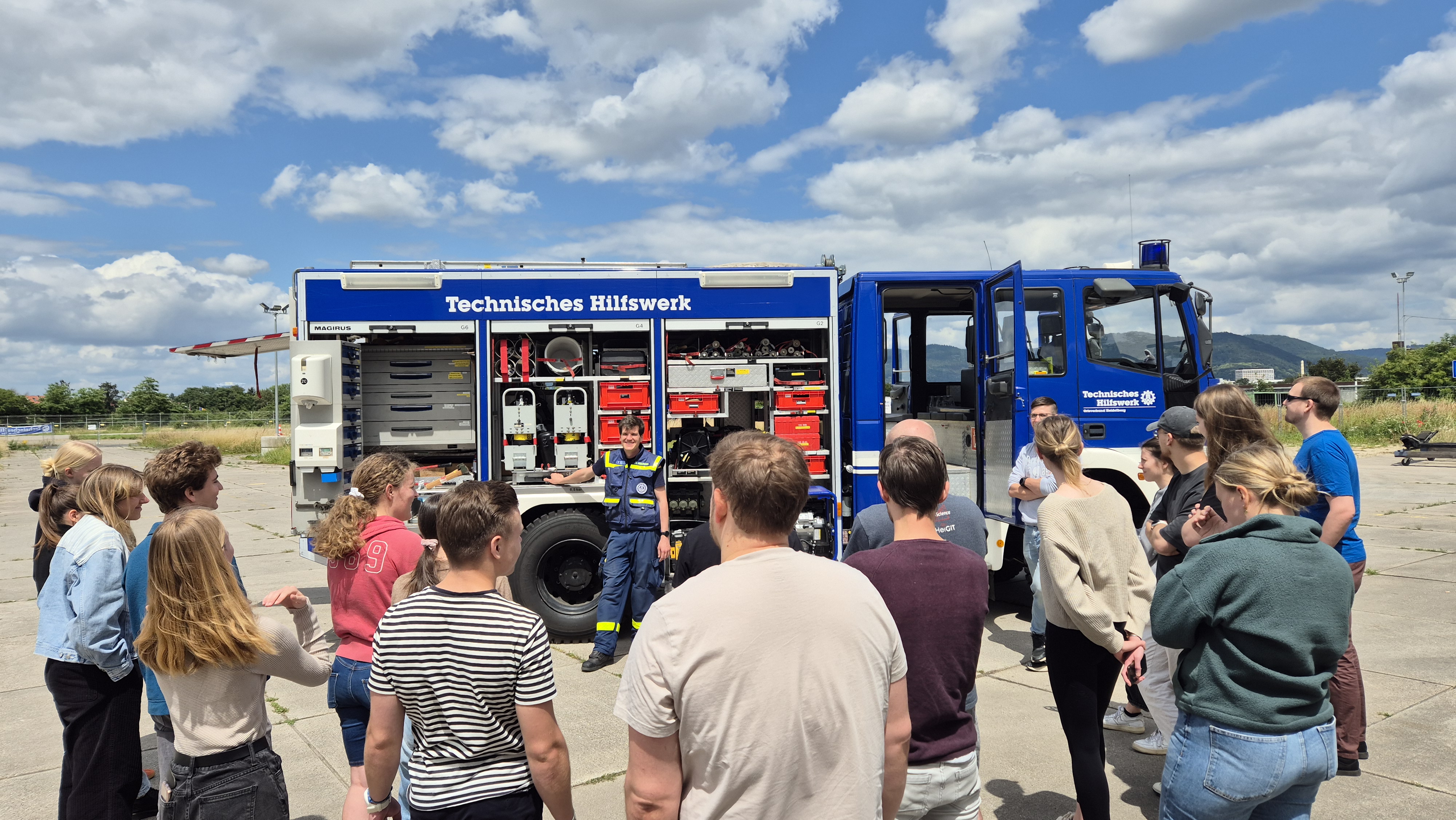
Vor zwei Wochen haben Studierende der Universität Heidelberg im Rahmen eines Seminars zu GIS for Disaster Risk Reduction, angeleitet von HeiGIT Mitarbeitenden, mehrere Services des HeiGIT in einem Feldversuch getestet. Dabei standen folgende Anwendungen im Fokus: openrouteservice, das disaster portal … Read More
Deutsch

Heute ist der „International Day for Disaster Risk Reduction“!
Wusstest du, dass der 13. Oktober „International Day for Disaster Risk Reduction (IDDRR)“ – der Internationale Tag für die Reduzierung des Katastrophenrisikos ist? Seit 1989 nutz das Büro der Vereinten Nationen für Katastrophenvorsorge diesen Tag, um eine globale Kultur des … Read More
HeiGIT at Summer School Disaster Risk Reduction 2023
Today we’d like to tell you about the Summer School Disaster Risk Reduction 2023 event hosted by the Environmental Campus of UAS Trier in Germany and organized by the German Committee for Disaster Reduction (DKKV). During this one-week course that … Read More
Paper presentation at AGILE: “Exploring MapSwipe as a Crowdsourcing Tool for (Rapid) Damage Assessment: The Case of the 2021 Haiti Earthquake”
Unter dem Hauptthema “Spatial data for design” wird die 26. AGILE Konferenz diese Woche in Delft, Niederlanden veranstaltet. Neben einer Vielzahl an geo-räumlichen Themen spielt das Katastrophenmanagement noch immer eine entscheidende Rolle in GIScience. Simon Groß und Sven Lautenbach werden … Read More
Gastvorlesungen über freiwillig zur Verfügung gestellter geografischer Informationen an der UC Chile
Im Mai 2023 besuchte Prof. Dr. Alexander Zipf gemeinsam mit Anne Schauß die UC Chile (Pontificia Universidad de Catolica de Chile) und das Heidelberg Center for Latin America (HCLA) in Santiago (Chile) und stellte in zwei öffentlichen Vorträgen vergangene und … Read More
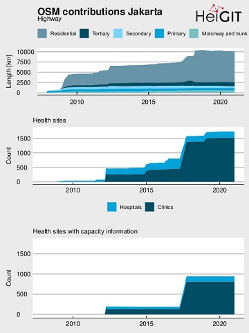
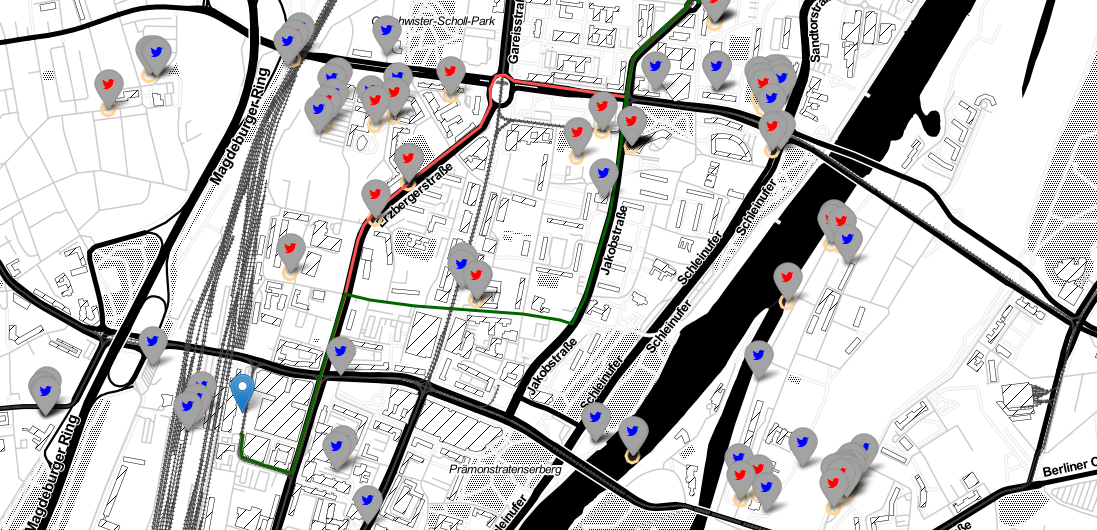
Flood Impact Assessment on Road Network and Healthcare Access at the example of Jakarta, Indonesia
Extreme natural events create catastrophic situations for cities and their populations. Due to climate change and anthropogenic activities, the number and intensity of these events has steadily increased at the global scale. Floods are the most common natural disaster worldwide, … Read More
CALL FOR PAPERS – GIS Track at 18th International Conference on Information Systems for Crisis Response and Management (ISCRAM 2021)
CALL FOR PAPERS – 18th International Conference on Information Systems for Crisis Response and Management (ISCRAM 2021) May 23-26, 2021, Virginia, USA – https://www.drrm.fralinlifesci.vt.edu/iscram2021/ Virginia Tech Track: Geospatial Technologies and Geographic Information Science for Crisis Management (GIS) https://www.drrm.fralinlifesci.vt.edu/iscram2021/files/CFP/ISCRAM2021-Track10-Geospatial_Technologies Deadline for … Read More
GeoNet.MRN at Smart City Expo World Congress Barcelona 2019
Last week was the Smart City Expo World Congress 2019 took place in Barcelona. Our region geoinformation network GeoNet.MRN was there with a booth presenting the members of GeoNet.MRN, among others the GIScience Research Group / HeiGIT at Heidelberg University. … Read More
Tools for Disaster Risk Reduction by HeiGIT – Celebrating the International Day for Disaster Risk Reduction
Today we celebrate the International Day for #DisasterRiskReduction. HeiGIT offers a growing set of tools and services that support humanitarian aid during and before disasters. Examples include work in the context of the Missing Maps initiative, like conceptualising and extending … Read More

Teaching at the Heidelberg Center for Latin America in Santiago de Chile
This year, Sabrina Marx and Martin Hilljegerdes were teaching the block course “GIS 2” at the Heidelberg Center for Latin America (HCLA) in Santiago de Chile. The course is part of the international Master program “Governance of Risks and Resources”, … Read More
HeiGIT/ GIScience at ISCRAM conference in Valencia
19th-22nd of May, the 16th Information Systems for Crisis Response and Management (ISCRAM) conference is taking place in Valencia. Likewise to previous years, the GIScience Research Group/HeiGIT are taking part and supporting with several contributions. Martin Hilljegerdes will present a … Read More
HeiGIT at German Red Cross “Digitalisation in Civil Protection” congress
HeiGIT members Melanie Eckle and Martin Hilljegerdes were invited to the “Digital in civil protection” congress of the Landesverband Westfalen-Lippe in Münster to share insights and to present current activities all around “Potentials of Open Data and Digital Humanitarians for … Read More
Jupyter Notebook: Combining Twitter Data and OpenRouteService Directions API
In the case of a disaster fast response is important and life saving. Information on blocked streets is crucial, but a the same time this infornations needs to be considered by routing engines in real-time. However, many routing engines use … Read More