
Ab jetzt kannst du mit der MapSwipe Web App von deinem Browser aus weltweit helfen und einen Unterschied machen! Seit 2015 nutzt MapSwipe die kollektive Stärke von Freiwilligen, um aktiv zu Geodatenprojekten beizutragen. Frei zugängliche Geodaten spielen eine zunehmend große … Read More
Deutsch
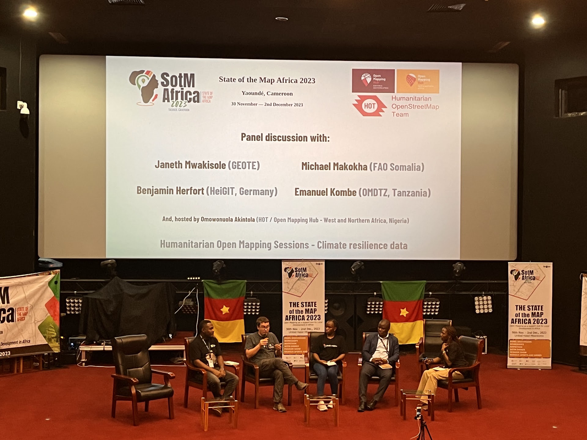
SOTM Africa und Missing Maps Gathering: Ein Rückblick
Vor kurzem fand in Yaoundé, Kamerun die OpenStreetMap (OSM)-Konferenz „State of the Map Africa 2023“ statt. Es war die vierte mal, dass diese Konferenz veranstaltet wurde. Die State of the Map war eine großartige Gelegenheit, die Menschen kennenzulernen, die im … Read More
Participatory Mapping taken one step further – The new version of the Sketch Map Tool
Sketch Map Tool (SMT) – An easy-to-use way to create and digitalize paper maps for offline data collection in the field The HeiGIT (Heidelberg Institute for Geoinformation Technology) team recently launched a new version of the Sketch Map Tool – … Read More
HGG Vortrag: Digitale Geographie im Katastrophenmanagement
Einladung Vortrag Online: Dienstag, 14. Dezember 2021, 19:15 Uhr Melanie Eckle-Elze, Benjamin Herfort, Dr. Carolin Klonner Digitale Geographie im Katastrophenmanagement Klimawandel, Bevölkerungswachstum, Verstädterung und weitere zunehmende Landnutzungsveränderungen führen dazu, dass immer mehr Menschen in Risikogebieten leben. Um die vorhandenen Risiken … Read More
Stellenangebot vom DRK Generalsekretariat Berlin zur Unterstützung der HeiGIT Kooperation
Sie haben Erfahrung in den Bereichen Geoinformatik und Open Data und würden gerne dazu beitragen, dass Menschen in Deutschland und weltweit Hilfe erhalten? Sie würden gerne als Teil des größten humanitären Netzwerks der Welt helfen, dessen zukünftige Ausrichtung in diesen … Read More
FOSS4G 2021 Videos with HeiGIT contributions online – OSM data quality and MapSwipe
Recently videos with our contributions by HeiGIT to the FOSS4G conference were put online. Did you miss the event? Now you can watch whenever you like 🙂 Benni by HeiGIT explains who to use the ohsome.org framework to develop an … Read More
HeiGIT und das Deutsche Rote Kreuz beim Digitaltag 2021
Am 18.06.2021 findet der Bundesweite Digitaltag 2021 der Initiative „Digital für alle“ statt. Der Digitaltag ist eine Plattform, auf der digitale Projekte und Aktionen aus der Zivilgesellschaft vorgestellt werden und das Thema Digitalisierung von verschiedenen Seiten beleuchtet wird. Mit dem … Read More
Mapathons im Rahmen der OSM Geography Awareness Week – OSM GeoWeek
Kooperation ist in der Humanitären Hilfe oft der Schlüssel, um Menschen in Not schnell und effizient helfen zu können. Das gilt insbesondere beim Austausch von Informationen und Kartenmaterial. Besonders herausfordernd sind die Situationen für Humanitäre Organisationen in Gebieten, von denen … Read More
HeiGIT support for Forecast-based Financing feature around open data initiatives for anticipatory action
Current COVID 19 related activities of the Humanitarian OpenStreetMap Team (HOT), Red Cross Red Crescent Climate Center and HeiGIT are featured in a blog series around Forecast-based Financing. The blog post, “Anticipating and addressing epidemics – the potential of open … Read More
OSM Missing Areas Identification paper is featured in August by ISPRS Journal of Photogrammetry and Remote Sensing
We are pleased that our article has been selected by the editors of ISPRS Journal of Photogrammetry and Remote Sensing as the featured Article in August 2020. This means it will be available open access for 1 year. Get your … Read More
Physische Erreichbarkeiten von Krankenhäusern in Subsahara Afrika – Analyse und Ergebnisse bei COVID-19 Symposium vorgestellt
Vom 06. bis zum 08. Juli fand das Online Symposiums “COVID-19 als Zäsur? Geographische Perspektiven auf Räume, Gesellschaften und Technologien in der Pandemie” statt. Teilnehmer aus Geographie, Medizin, Public health und meidizinischer Geographie diskutierten über drei Tage in sechs verschiedenen … Read More
Humanitarian OpenStreetMap Team has been selected by the Audacious Project
The Humanitarian OpenStreetMap Team (HOT) has announced major financial support from the Audacious Project, which will be provided over the next five years. HOT aims to use this funding to grow OpenStreetMap (OSM) communities in 94 countries. By engaging one … Read More

Exploring OSM for healthcare access analysis in Sub-Saharan Africa
Using hospital locations and the ORS Isochrone service, we have created a method for comparing physical access to healthcare in Sub-Saharan Africa. Hospital locations were derived from OpenStreetMap and compared against another free available dataset. Results indicate strong similarity in … Read More

MapSwipe wins Global Mobile Award for the Best Mobile Innovation Supporting Emergency or Humanitarian Situations
This week, at the prestigious GSMA MWC series (formally known as Mobile World Congress) MapSwipe was awarded the top prize in the Global Mobile Awards’ category for the Best Mobile Innovation Supporting Emergency or Humanitarian Situations. The award recognizes how … Read More
Invitation to GIScience colloquium talks related to Humanitarian Aid
We are happy to annouce two higly interesting upcomming presentations in the GIScience colloquium in the next weeks. Everybody interested is invited to join the presentations and the discussion afterwards. The use of geoinformatics at the German Red Cross Katharina … Read More
HeiGIT at International Dialogue Platform on Forecast-based Financing
Next week, November 12-14th, the 7th International Dialogue Platform on Forecast-based Financing is taking place in Berlin. The platform is organized by the German Red Cross (GRC), World Food Program, German Humanitarian Assistance, International Federation of Red Cross and Red … Read More
HeiGIT support for Humanitarian Village and Mapathon at Humanitarian Congress in Berlin 2019
On October 17/18th the Humanitarian Congress is organized in Berlin by Médecins Sans Frontières/Ärzte ohne Grenzen (MSF), Médecins du Monde/Doctors of the World (MdM), German Red Cross (GRC) and Berlin Chamber of Physicians. For more than 20 years, this congress … Read More
MapSwipe 2.0: Reimagining how a mobile app can support humanitarian response worldwide
In 2015, MapSwipe began as a solution to a complex question: how do we better identify where communities and populations are, allowing mapping to be more efficient and effective? Using a simple mobile app, volunteers are able to swipe through … Read More
HeiGIT beim Tag der offenen Tür im Auswärtigem Amt, 17.-18. August
Wer steckt eigentlich hinter Missing Maps? Und wie können auch Sie in dem humanitären Mappingprojekt aktiv werden? Besuchen Sie uns heute beim Tag der offenen Tür im Auswärtigem Amt an unserem gemeinsamen Stand mit dem Deutschen Roten Kreuz. Weitere Informationen … Read More
KI-Exponat des HeiGIT zu MissingMaps und Permafrostdetektion auf dem Portal zum Wissenschaftsjahr 2019 “Künstliche Intelligenz”
Seit einiger Zeit findet sich das gemeinsame Exponat des HeiGIT und des Alfred-Wegener-Instituts Helmholtz-Zentrum für Polar- und Meeresforschung für die Ausstellung “Künstliche Intelligenz” auf der “MS Wissenschaft” auch auf dem Webportal zum Wissenschaftsjahr 2019. Das Thema “Künstliche Intelligenz” des Wissenschaftjahres … Read More