August 19th marks World Humanitarian Day (WHD) to recognize the efforts of humanitarian workers and to advocate for the survival, well-being and dignity of people affected by crises, and for the safety and security of aid workers. One of many … Read More
Deutsch

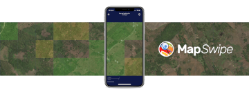
Die neue MapSwipe Web App ist da!
Ab jetzt kannst du mit der MapSwipe Web App von deinem Browser aus weltweit helfen und einen Unterschied machen! Seit 2015 nutzt MapSwipe die kollektive Stärke von Freiwilligen, um aktiv zu Geodatenprojekten beizutragen. Frei zugängliche Geodaten spielen eine zunehmend große … Read More
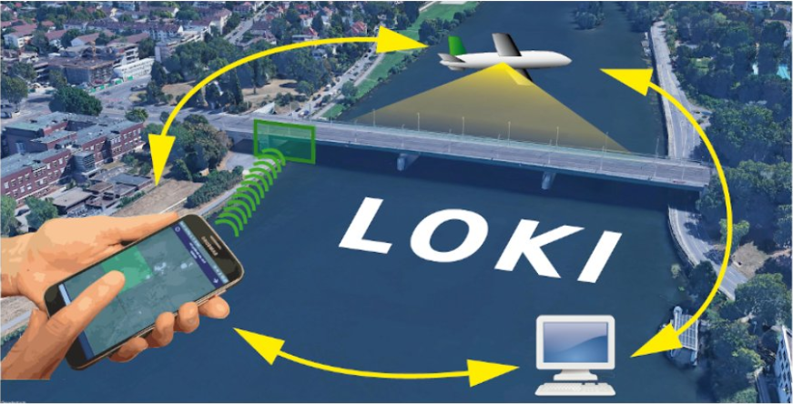
Das LOKI Projekt: Schäden nach Erdbeben schnell einschätzen
Wenn durch Erdbeben Schäden an der Infrastruktur verursacht werdend, ist es von entscheidender Bedeutung, das Ausmaß der Schäden rasch und präzise einschätzen zu können. Die Bewältigung dieser Herausforderung war Ziel des LOKI Projekts (Luftgestützte Observation Kritischer Infrastrukturen). Das Projekt lief … Read More
HeiGIT and GIScience at AGILE 2023
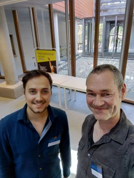
Foto: Simon Groß und apl. Prof. Dr. Sven Lautenbach auf der 2023 AGILE Konferenz. Anfang dieses Monats hat die Association of Geographic Information Laboratories in Europe (AGILE) ihre 2023 Konferenz veranstaltet, und Mitglieder des GIScience- und HeiGIT-Teams steuerten Präsentationen, Analysen … Read More
Paper presentation at AGILE: “Exploring MapSwipe as a Crowdsourcing Tool for (Rapid) Damage Assessment: The Case of the 2021 Haiti Earthquake”
Unter dem Hauptthema “Spatial data for design” wird die 26. AGILE Konferenz diese Woche in Delft, Niederlanden veranstaltet. Neben einer Vielzahl an geo-räumlichen Themen spielt das Katastrophenmanagement noch immer eine entscheidende Rolle in GIScience. Simon Groß und Sven Lautenbach werden … Read More
HeiGIT at MSF Geo Week 2022
Diesen Juni fand die GIS-Woche 2022 von Ärzte ohne Grenzen (MSF) wieder im schönen Prag statt. Nahezu das gesamte MSF-Team, das sich mit Geodaten und Geodatenanalyse befasst, nahm an der Veranstaltung teil, die eine fantastische Gelegenheit bot, mehr über die … Read More
Räumliche Daten für die Gesellschaft – HeiGIT in die Zukunft geführt
Unterführungen, Treppen und hohe Bordsteinkanten sind für Menschen mit Gehbeeinträchtigungen eine große Herausforderung. Ein maßgeschneiderter Routenplaner kann aber ihre Mobilität erhöhen, indem er Wege mit möglichst wenigen Hindernissen berechnet. Dieses Beispiel zeigt, wie Geoinformationstechnologie und Geoinformatik speziellen Gruppen in der … Read More
HGG Vortrag: Digitale Geographie im Katastrophenmanagement
Einladung Vortrag Online: Dienstag, 14. Dezember 2021, 19:15 Uhr Melanie Eckle-Elze, Benjamin Herfort, Dr. Carolin Klonner Digitale Geographie im Katastrophenmanagement Klimawandel, Bevölkerungswachstum, Verstädterung und weitere zunehmende Landnutzungsveränderungen führen dazu, dass immer mehr Menschen in Risikogebieten leben. Um die vorhandenen Risiken … Read More
HeiGIT and GIScience at Virtual Conference of the Red Cross Red Crescent Urban Collaboration Platform 2021
On Friday, November 26th, Dr. Carolin Klonner (GIScience Research Group) and Melanie Eckle-Elze (HeiGIT) will be supporting the Urban Context Unit of German Red Cross (GRC) in the “Data and Digitalisation in Urban Humanitarian Action” session at the Virtual Conference … Read More
FOSS4G 2021 Videos with HeiGIT contributions online – OSM data quality and MapSwipe
Recently videos with our contributions by HeiGIT to the FOSS4G conference were put online. Did you miss the event? Now you can watch whenever you like 🙂 Benni by HeiGIT explains who to use the ohsome.org framework to develop an … Read More
MapSwipe is App of the Day in Apple AppStore
MapSwipe has ben announced as ‘App of the Day‘ in the Apple AppStore! (27.08.2021) Thank you to all our volunteers for the continued help and support which keeps the app going. Read the blogpost here: https://apps.apple.com/ca/story/id1559236909 The team at the … Read More
One step forward for “25 Mapathons” – today Online Mapathon at Humanitarian Congress
The project “25 Mapathons” made an important step forward by successfully completing the first four Mapathons of the project. Two Mapathons were conducted with German Red Cross (GRC) members from the Red Cross Regional association of Westfalen-Lippe. Another two Mapathons … Read More
HeiGIT gGmbH is One Year Old Today!
Today (1st July 2020) marks the first birthday of HeiGIT gGmbH! Over this first year, HeiGIT has been involved a large number of events, projects, publications, and press coverage. Founded on the 1st July 2019, HeiGIT is a non-for-profit organisation … Read More
Humanitarian OpenStreetMap Team has been selected by the Audacious Project
The Humanitarian OpenStreetMap Team (HOT) has announced major financial support from the Audacious Project, which will be provided over the next five years. HOT aims to use this funding to grow OpenStreetMap (OSM) communities in 94 countries. By engaging one … Read More

MapSwipe wins Global Mobile Award for the Best Mobile Innovation Supporting Emergency or Humanitarian Situations
This week, at the prestigious GSMA MWC series (formally known as Mobile World Congress) MapSwipe was awarded the top prize in the Global Mobile Awards’ category for the Best Mobile Innovation Supporting Emergency or Humanitarian Situations. The award recognizes how … Read More
MS Wissenschaft beendet Tour zur Künstlichen Intelligenz – aber weiter geht es im Web – auch mit unserem Exponat zu Trainingsdaten für Satellitenbilder
Gerade beendete die MS Wissenschaft ihre Tour durch 31 Städte zwischen Berlin und Wien in diesem Wissenschaftsjahr zum Thema “Künstliche Intelligenz“. 85.000 Menschen – Schulklassen, Familien und Interessierte aller Altersklassen – besuchten die Ausstellung zum Thema lernende Computersysteme an Bord … Read More
MapSwipe 2.0: Reimagining how a mobile app can support humanitarian response worldwide
In 2015, MapSwipe began as a solution to a complex question: how do we better identify where communities and populations are, allowing mapping to be more efficient and effective? Using a simple mobile app, volunteers are able to swipe through … Read More
Mapathon at “JKG” during German Congress for Geography 2019
This year the bi-annual German Congress for Geography was held in Kiel in northern Germany. The conference is the main platform for German speaking researchers to exchange recent research results in the field of geography. Besides this, a growing number … Read More
Die MS Wissenschaft ist in Heidelberg
Bis zum 01.09.2019 kann die Austellung auf der MS Wissenschaft zum Thema “Künstliche Intelligenz” in Heidelberg besucht werden. Wir waren da und sind begeistert! Für die Ausstellung hat das HeiGIT gemeinsam mit dem Alfred-Wegener-Institut für Polar- und Meeresforschung in Potsdam … Read More
KI-Exponat des HeiGIT zu MissingMaps und Permafrostdetektion auf dem Portal zum Wissenschaftsjahr 2019 “Künstliche Intelligenz”
Seit einiger Zeit findet sich das gemeinsame Exponat des HeiGIT und des Alfred-Wegener-Instituts Helmholtz-Zentrum für Polar- und Meeresforschung für die Ausstellung “Künstliche Intelligenz” auf der “MS Wissenschaft” auch auf dem Webportal zum Wissenschaftsjahr 2019. Das Thema “Künstliche Intelligenz” des Wissenschaftjahres … Read More