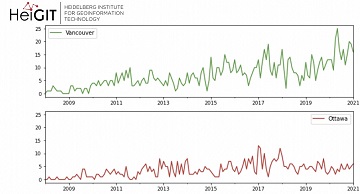
Welcome back to our blog post series ”ohsome Region of the Month” where you can find information on potential applications of the ohsome API. If you’re new to this format…
Welcome back to the ohsome region of the month format where you can learn and get inspiration about potential applications of the ohsome API. This time we looked at forest-related…
As a little Easter present, we published the first version of the ohsome-py Python package today. ohsome-py helps you extract and analyse OpenStreetMap history data using the ohsome API and…
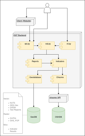
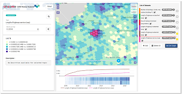
The #ohsome quality analyst (short: OQT) has been online and accessible through its web-interface now for quite some weeks already (see the introductory blog post as a reference). The website…
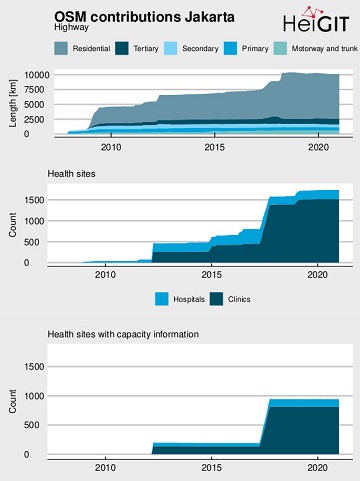
Extreme natural events create catastrophic situations for cities and their populations. Due to climate change and anthropogenic activities, the number and intensity of these events has steadily increased at the…
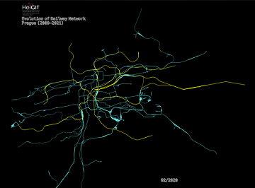
Welcome back to another #ohsome blog post written by our awesome student assistent Sarah! This time we will look at the completeness of railway network data of one specific city…
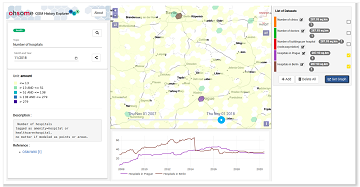
The Ohsome Quality analysT (short OQT) is the name of a new software implemented by HeiGIT that is based on the #ohsome framework. Its main purpose is to compute quality…
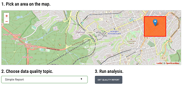
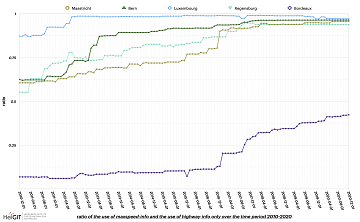
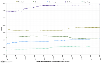
Welcome to part 2 of the #ohsome street network analysis. If you haven’t read the first part yet, you can do so following this link. As promised, this week we…
Here we go again: The first #ohsome blog post of 2021. This time, one of our new student assistants Sarah was dealing with street networks and their quality in order…
Erhalten Sie mit ohsomeHeX wertvolle Einblicke in die Qualität und den Entwicklungsprozess von OpenStreetMap-Daten! (see for english version here) Das HeiGIT Big Data Team freut sich zur Exploration der Veränderungen…
Get valuable insights into the quality and development process of OpenStreetMap data with ohsomeHeX! We are proud to announce a new release that provides a completely redesigned UI that makes…
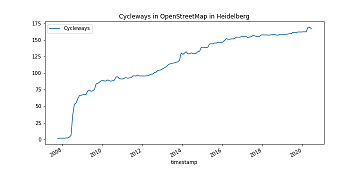
It’s CITY CYCLING time – some of you may even be involved in your municipality – a good opportunity to have a look on the OpenStreetMap (OSM) cycling ways in…
Recently we’ve had the first minor release 1.1 of the ohsome API, which brings several new features and upgrades. In the following lines we want to present to you the…
We are happy to share that our paper “A Comprehensive Framework for Intrinsic OpenStreetMap Quality Analysis” (Barron, Neis, Zipf 2013) belongs to the top 5 most cited papers of the…
As you may already know from the latest blog posts, new advancements are brought with the release 1.0 of the #ohsome API. One minor function involves the correctness of parameters…
After more than a decade of rapid development of volunteered geographic information (VGI), VGI has already become one of the most important research topics in the GIScience community. Almost in…
As we’ve announced it in a previous post, the Open Source release 1.0 of the ohsome API has finally arrived. As a reminder, or for those of you that hear…
Big news from the ohsome team: the release 1.0 of one of our major services, the ohsome API for ohsome OpenStreetMap History Analytics, is on the doorstep. We are bringing…
Around 55 participants gathered in Malta for the 3rd International Workshop on Spatial Data Quality 2020 from 28th to 29th of January. Among national mapping agencies, software providers and standardization…