The new year started in the openrouteservice team at HeiGIT with the release of openrouteservice 4.7.2. In this release there were a number of bug fixes, but also some new features. The main one of these is the inclusion of … Read More
English
openrouteservice-js – your JS library for spatial node applications!
In addition to our previously released and highly appreciated python and R libraries we now offer an additional JavaScript API making the usage of the openrouteservice ecosystem covering the entire globe based on OpenStreetMap in your web applications terribly simple. … Read More
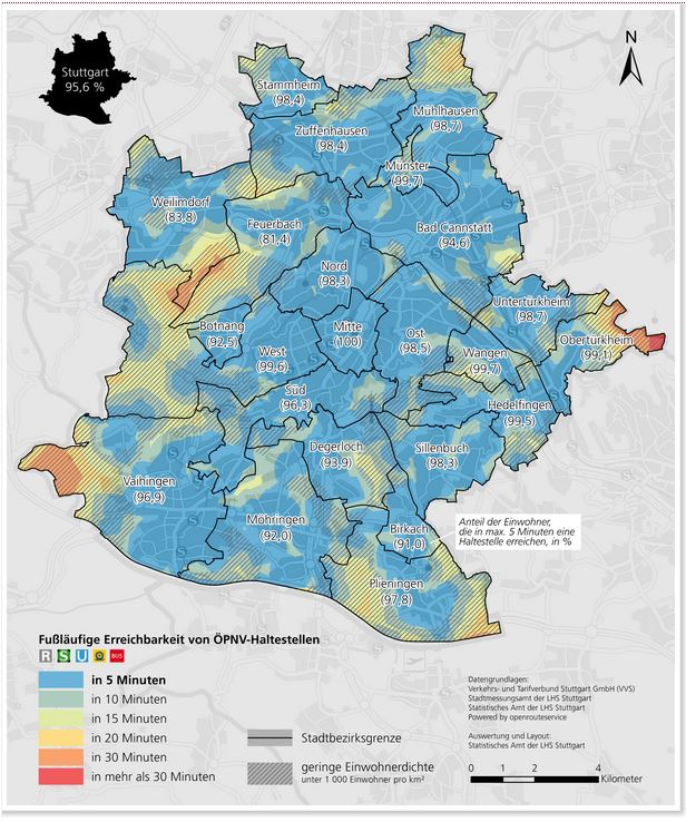
Accessibility analysis of public transport in Stuttgart
The Statistical Office of the City of Stuttgart determined the walking time to the nearest public transport stop for every place in the city using our QGIS plugin OSM Tools. With OSM Tools it only takes a few mouse clicks … Read More

New OpenRouteService API playground
After the release of the new OpenRouteService dashboard the team has worked on a new interactive API documentation application named API Playground , that allows the users to explore all the OpenRouteService API services, parameters and responses in an intuitive … Read More
Generating Customized Pleasant Pedestrian Routes Based on OpenStreetMap Data
In a newly published open access paper, we present a system that generates customized pedestrian routes entirely based on data from OpenStreetMap (OSM). The system enables users to define to what extent they would like the route to have green … Read More
openrouteservice elevation goes farther north than ever before
Last week we have been upgrading the openrouteservice, and with that has come the ability to include elevation information in routing pretty much anywhere on the globe (sorry people on Antarctica, but we don’t have routing for you just yet). … Read More
MeinGrün – project proposal approved (mFund BMVI)
Informationen und Navigation zu urbanen Grünflächen in Städten – meinGrün Neues mFund Kooperations-Projekt meinGrün wird vom BMVI gefoerdert. Problemstellung Um in Städten trotz Wachstum und Nachverdichtung eine hohe Lebensqualität zu sichern, spielen Grünflächen eine essentielle Rolle, da sie sich positiv … Read More

Celebrating 10 Years of Openrouteservice – The First OpenStreetMap Route Planner
Exactly 10 years ago openrouteservice.org came online for the very first time. Back then it was the very first online routing service consuming data from OpenStreetMap.org covering larger areas. So to say it is ‘the original‘ OSM routing service. It … Read More

Openrouteservice for Disaster Management: Supporting Humanitarian Logistics with Hourly Updates
The Humanitarian OpenStreetMap Team (HOT) provides immediate support for disaster or humanitarian responses by coordinating and activating a global network of mappers that contribute up-to-date geodata to the OSM database. For example, after the Nepal earthquake 2015 volunteers added up … Read More
Openrouteservice-py now available on PyPi – Easy Routing, Geocoding, Isochrones and Matrix Routing with Python!
We have finally developed a pretty handy python API for all of you pythoniasts out there. This library makes requests to the openrouteservice API extremely simple. With this you will be able to query the following services with a couple … Read More