August 19th marks World Humanitarian Day (WHD) to recognize the efforts of humanitarian workers and to advocate for the survival, well-being and dignity of people affected by crises, and for the safety and security of aid workers. One of many factors that are essential for effective humanitarian response and the security of people on site is the availability of reliable maps and up-to-date geodata of crisis areas. This is usually ensured through crowdsourcing and there are many tools and projects that enable you to contribute if you are interested in actively supporting humanitarian workers.
One such project is Missing Maps which was co-foundend by the American Red Cross, the British Red Cross, HOT, and MSF. Missing Maps is an open, collaborative project whith the goal to provide accurate and up-to-date maps of crisis areas to humanitarian workers. One of HeiGIT’s contributions to the Missing Maps project is the co-development and maintenance of MapSwipe, a tool that enables individuals to contribute to humanitarian projects from anywhere.
Depending on the requirements of their project, MapSwipe users can contribute in three different ways: find, compare and verify. “Find” is the default way in which MapSwipe can be used. Volunteers can pinpoint specific features in a certain area, allowing mappers to only focus on areas where they know these features have not been mapped yet. An example where this mode was applied is the COVID-19 vaccination campaign from 2021 in South Sudan. This initiative by HOT enabled volunteers to fill data gaps by locating roads and buildings, expanding the available information on critical infrastructure and population.
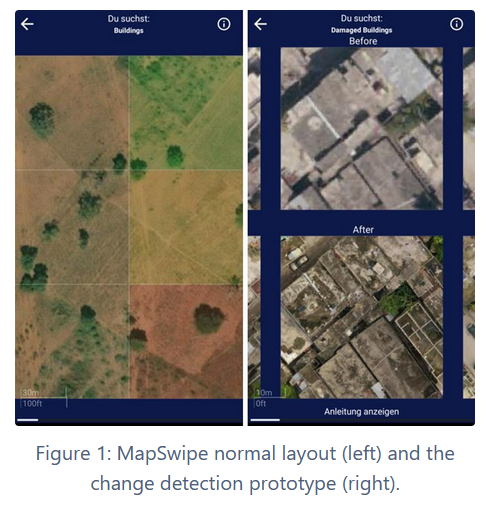
The second function, “compare”, is suited for projects that focus on change detection or, more precisely, on damage assessment. In the aftermath of the earthquake in Les Cayes, Haiti in 2021, HOT prepared a MapSwipe “compare” project for volunteers to look at pre and post event imagery to determine if damage was visible. Information like this can be a critical factor during disaster response efforts. It enables humanitarian organizations to determine which areas to prioritize, allowing for quick decision making.
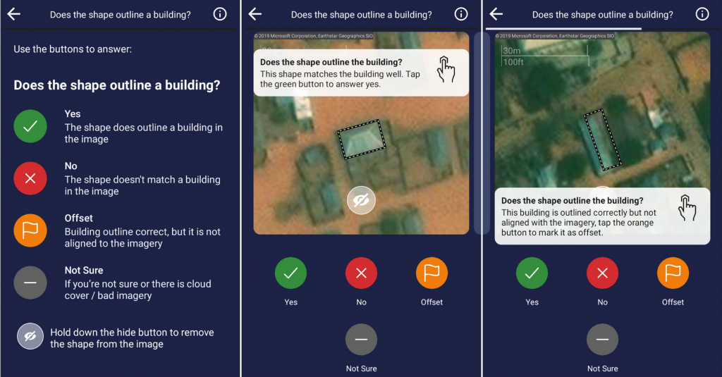
With the “validate” feature, volunteers can assess the quality of past mapping activities in OpenStreetMap (OSM) and identify which features have been mapped correctly, and which have not. This task type was developed in response to the varying completeness of OSM building footprints and was tested during the LOKI project, another collaborative project in which HeiGIT was envolved. LOKI employed an interdisciplinary approach do develop a fast and reliable method for earthquake damage assessment based on UAV imagery. The results of this initial test indicate that crowdsourced approaches are a viable strategy to close data gaps in OSM building footprints. Furthermore, the results of “validate”-projects in MapSwipe can be used to optimize future MapSwipe projects in the planning stage.
As the examples above show, volunteer work plays a significant role in the development and execution of disaster management and response strategies. It should also be acknowledged how it can positively impact crises of a smaller, personal scale such as the sad but inspirational case of Rohit Bhadauria, a paraglider who went missing in 2021. Since working with MapSwipe requires little to no previous training or mapping experience, Rohit’s friends and family were able to set up a MapSwipe campaign for volunteers to look for his parachute and eventually locate his body. Even though the cases mentioned here give insight insight in only a fraction of all humanitarian projects, they all show that even the smallest amount of effort helps to change things for the better.
Again, we want to emphazise the importance of each humanitarian organization, project, worker and volunteer world wide. We are countinuously working on tools and methods to support their collective work and we hope to inspire more people every day to become active.
For more information on how to implement MapSwipe into your projects visit mapswipe.org or feel free to contact info@mapswipe.org. To keep up with future developments and releases related to this project as well as other efforts to advance geospatial technology in the mobility, humanitarian aid, and data analytics space, follow the social media channels and stay up to date on our blog.