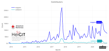
Since 2010 organized humanitarian mapping has evolved as a constant and growing element of the global OpenStreetMap (OSM) community. With more than 8,000 projects in 150 countries humanitarian mapping has become a global community effort. Due to this large amount … Read More
English
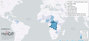
Humanitarian OSM Stats: How to monitor humanitarian mapping in the HOT Tasking Manager? – Part 4
Since 2010, organized humanitarian mapping has evolved as a constant and growing element of the global OpenStreetMap (OSM) community. With more than 7,000 projects in 150 countries, humanitarian mapping has become a global community effort. Due to this large amount … Read More
Successful PhD Defense by Amin Mobasheri on OSM quality enrichment for wheelchair routing
Last Friday Amin Mobasheri of the GIScience Research Group Heidelberg University successfully defended his PhD in Geoinformatics. Due to the Corona pandemy the defense was conducted in hybrid mode with the committee members participating virtually and only Prof. Zipf and … Read More
Introducing the Ohsome Quality analysT (OQT)
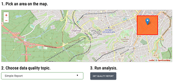
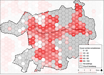
The Ohsome Quality analysT (short OQT) is the name of a new software implemented by HeiGIT that is based on the #ohsome framework. Its main purpose is to compute quality estimations on OpenStreetMap (OSM) data. Any end user such as … Read More
A Comprehensive Framework for Intrinsic OpenStreetMap Quality Analysis among Most Cited Paper in Transactions in GIS
We are happy to share that our paper “A Comprehensive Framework for Intrinsic OpenStreetMap Quality Analysis” (Barron, Neis, Zipf 2013) belongs to the top 5 most cited papers of the international journal “Transaction in GIS” (TGIS). Only recently we became … Read More

How to become ohsome part 6: Introducing the magical filter parameter
We are back again with a fresh part of the How to become ohsome blog series. In case this 6th part of the series is your first one, or you have not heard from our awesome OpenStreetMap History Data Analytics … Read More
Sphinx is ohsome – new documentation of the ohsome API
What does the tool behind the recently published documentation of the ohsome API have in common with a statue made of stones in Egypt? – Apart from the name, both are of course awesome (and now also ohsome). As previously … Read More

ohsome API 1.0 is here
As we’ve announced it in a previous post, the Open Source release 1.0 of the ohsome API has finally arrived. As a reminder, or for those of you that hear “ohsome” for the first time, the aim of the ohsome … Read More
GIScience Contributions to the 2019 State of the Map Academic Track proceedings
Recently the SOTM 2019 Heidelberg Academic Track Proceedings have been published. GIScience Research Group Heidelberg and HeiGIT contributed several talks and posters. Below you can find an overview. Contact us if you are interested in further details on ongoing research. … Read More
ohsome presentation in Malta at the 3rd International Workshop on Spatial Data Quality
Around 55 participants gathered in Malta for the 3rd International Workshop on Spatial Data Quality 2020 from 28th to 29th of January. Among national mapping agencies, software providers and standardization organizations, HeiGIT had the opportunity to present its ohsome – … Read More
Recap: Keynote on Smart Cities
Already in October 2019 Prof. Zipf was invited to give a keynote on “User Generated Geoinformation for Smart Cities” at the “Smart Cities, Smart Data, Smart Governance” ISPRS Conference at CEPT University in Ahmedabad (known for the Gandhi-Ashram), where he … Read More
Brownbag Presentation by Jennings Anderson (University of Colorado Boulder) on OpenStreetMap data analysis
We cordially invite you to a Brownbag presentation by our Guest Researcher Dr. Jennings Anderson! When? Tuesday, 8/10/2019, 1-2.30 pm Where? Seminar room 15, INF 348 Jennings is a postdoctoral researcher at the University of Colorado Boulder exploring new approaches … Read More
Successfull PhD Defence by Clemens Jacobs on Plausibility Estimation of Citizen Science Observations for Biodiversity
Last week Dr. Clemens Jacobs successfully defended his PhD about methods for assessing the data quality of citizen science observations of organisms. Congratulations, well done!!! We wish all the very best for the future! The research aimed at using geographic … Read More
Sonniges „meinGrün“ Konsortiumstreffen in Heidelberg
Letzte Woche fand das zweite große Konsortiumstreffen im Projekt „meinGrün“ in Heidelberg statt. Zusammen mit unseren Projektpartnern vom IÖR , DLR , ISB AG , dem Institut für Kartographie der TU Dresden , Terra Concordia (mundraub.org) und Urbanista haben wir … Read More
Preview: Spatial Joins using the OpenStreetMap History Database OSHDB
Max is two and loves spending Monday afternoons with his Dad at the playground. Finding a suitable playground however isn’t easy, since a few criteria must be met: there should be a bench and some trees nearby to get shelter … Read More
Analysing semantic associations in VGI data
Volunteered Geographic Information (VGI) such as OpenStreetMap (OSM) can be a rich resource for many applications. Therefor VGI-projects have to mitigate between the requirements of the the volunteers and the machines. On the one hand, the data format should be … Read More
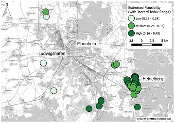
Plausible Parrots – HeiGIT’s OSHDB Supports Research in Citizen Science Data Quality
In the GIScience research group at Heidelberg University, a recent PhD research project by Clemens Jacobs has been looking into the data quality of citizen science observations of organisms. This research aims at using geographic context as an information source … Read More
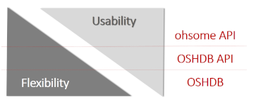
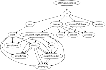
Ohsome – a high level architectural overview of the OSM History Analytics platform
Recently we introduced the ohsome platform for OSM History Analytics. Now we want to give you a high-level overview of the ohsome platform and the components it consists of. Ohsome API The ohsome platform is based on a three-layers API … Read More

The Ohsome API: dynamic OSM statistics for real-world applications
The Ohsome API, developed at HeiGIT, is part of the ohsome OSM history analytics platform (and yes, it is pronounced like the word “awesome” 😉. It serves as the connection between the OpenStreetMap History Database (OSHDB) and possible frontends, such … Read More
Introducing the ohsome OSM History Analytics Platform
The big spatial data analytics team at HeiGIT is currently developing the ohsome OpenStreetMap history analytics platform. Our aim is to make OSM’s full-history data more easily accessible for various kinds of data analytics tasks on a global scale. OpenStreetMap … Read More