Around 55 participants gathered in Malta for the 3rd International Workshop on Spatial Data Quality 2020 from 28th to 29th of January. Among national mapping agencies, software providers and standardization organizations, HeiGIT had the opportunity to present its ohsome – … Read More
English
HeiGIT presents ohsome Lab at FOSS4G 2019 Bucharest
This week, the annual conference FOSS4G (Free and Open Source Software for Geospatial) is taking place in Bucharest, Romania. The conference is organized by The Open Source Geospatial Foundation (OSGeo) and attracts over 1000 professionals from industry and academia each … Read More
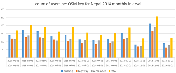
How to become ohsome part 5: Measuring numbers of users editing different OSM features
Besides dealing with a snake, making quality assessments, or generating comparable statistics, one needs to know how to handle the whole functionality provided by the ohsome API to really become ohsome. And to achieve exactly that, this blog presents the … Read More
OSHDB: a framework for spatio-temporal analysis of OpenStreetMap history data
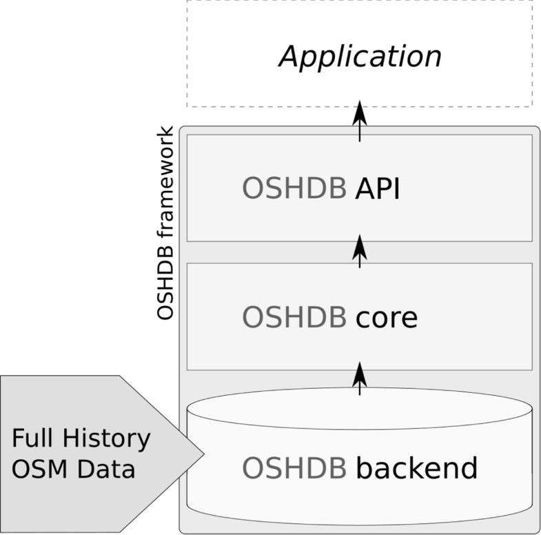
Earlier we published several blogposts introducing the ohsome platform and its parts (e.g. the ohsome API for example, which was often showcased here in the blog) and its backbone the OSHDB (very recently version 0.5 was published). A recent open … Read More
How to become ohsome part 4: handling a snake in a notebook on another planet
Welcome back to a new episode of how to become ohsome. Yes, you’ve read the heading correctly. We are really talking about a snake in a notebook on another planet. If you are familiar with one of the most used … Read More
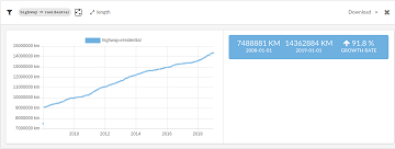
Preview: Spatial Joins using the OpenStreetMap History Database OSHDB
Max is two and loves spending Monday afternoons with his Dad at the playground. Finding a suitable playground however isn’t easy, since a few criteria must be met: there should be a bench and some trees nearby to get shelter … Read More
Global analyses are ohsome
We, the Big Spatial Data Analytics Group at HeiGIT have ohsome news to share: From now on, you can send your requests to our global ohsome API instance. So far, we’ve had a public instance for Nepal and Germany, but … Read More
How to become ohsome part 3: Identifying different mapping schemes
This is your first blog of the ohsome series? Before you might be confronted with any potential spoilers, you should better check out the first and the second part of this blog series (or the intro to the idea and … Read More
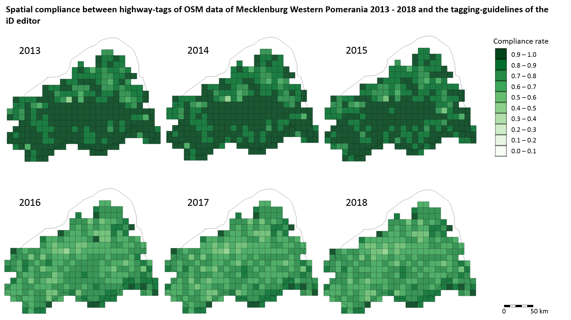
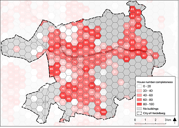
Conceptual compliance analysis with the OSHDB, Part 2
In a previous blog post we performed a conceptual compliance analysis between OSM data and several tagging-guidelines using the OSHDB API. The results were visualized in a linechart, comparing the different compliance ratio over several months. In this post we explain … Read More
Spatial conceptual compliance analysis with the OpenStreetMap History Database (OSHDB)
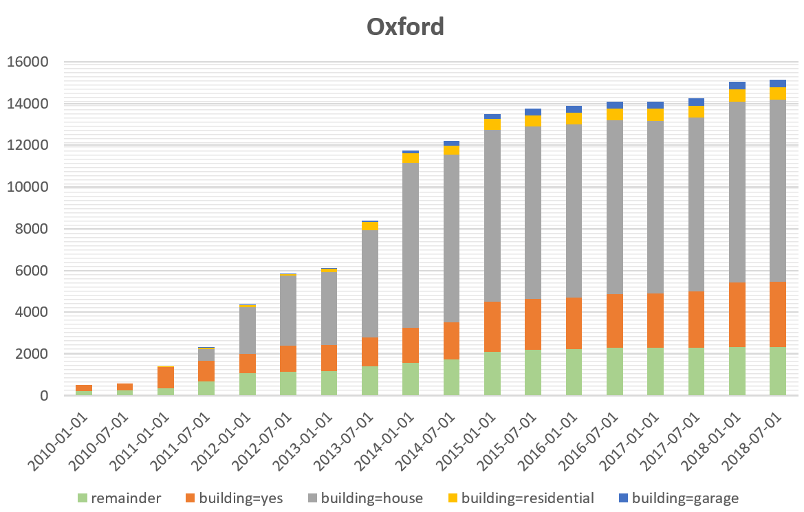
In a previous blog post we performed a conceptual compliance analysis between OSM data and several tagging-guidelines using the OSHDB API. The results were visualized in a line chart, comparing the different compliance ratio over several months. The following analysis … Read More
OpenStreetMap Analytics Development for OpenCities Africa
Recently a consultancy and development agreement about OpenStreetMap Analytics Development has been reached with the World Bank in the context of the Open Cities Africa project and the Global Facility for Disaster Reduction and Recovery (GFDRR) Open Data for Resilience … Read More
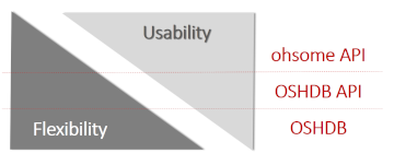
Ohsome – a high level architectural overview of the OSM History Analytics platform
Recently we introduced the ohsome platform for OSM History Analytics. Now we want to give you a high-level overview of the ohsome platform and the components it consists of. Ohsome API The ohsome platform is based on a three-layers API … Read More

Introducing the ohsome OSM History Analytics Platform
The big spatial data analytics team at HeiGIT is currently developing the ohsome OpenStreetMap history analytics platform. Our aim is to make OSM’s full-history data more easily accessible for various kinds of data analytics tasks on a global scale. OpenStreetMap … Read More