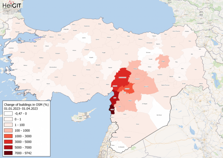
Featured Map: Percent change in each province of Türkiye and Syria of buildings in OSM. Data from OpenStreetMap, visualized using QGIS and the ohsome API plugin. Welcome back to the how to become ohsome series! If you’re new to the series, … Read More
Search Results for how to become ohsome
How to become ohsome part 14 – Advanced dashboarding
Hello again and welcome back to our “How to become ohsome” series where we demonstrate how you too can become ohsome with ohsome API! If you’re new to the series or need a refresher, check out the older installments in … Read More

How to become ohsome part 13 – An ohsome way to check if OSM is up to date
At long last, welcome to another addition of our How to become ohsome-series! This one is special because we’re discussing a third-party application that uses ohsome API as back-end to accumulate historical OSM data. Although this innovation isn’t directly about our API, … Read More

How to become ohsome part 12 – Using length and area as a predefined filter
Hello and welcome back to part 12 of our “How to become ohsome“-blog post series! If you’re new to this series, check out other blog posts of the series as well, in order to learn how you too, can become … Read More

How to become ohsome part 11 – counting contributions
Hello and welcome back to the How to become ohsome-blog series! We hope the new year started off well for you! If you’re new to the series, you should read our other posts in the series, as well as the … Read More

How to become ohsome part 10 – ohsome holiday contributions
Welcome back to our blog post series How to become ohsome, where you get short and simple explanations on how you can become ohsome yourself! This time, it’s all about our new endpoints, which enable you to track which contributions … Read More

How to become ohsome part 9 – More ways to access the ohsome API
At long last, welcome back to a new blog post of the “How to become ohsome“-series. As it’s been quite a while since you got an introduction to how to access the ohsome API, we would like to pick up … Read More

How to become ohsome part 8 – complex analysis with the magical filter parameter
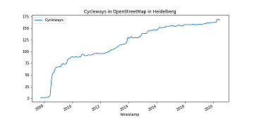
It’s CITY CYCLING time – some of you may even be involved in your municipality – a good opportunity to have a look on the OpenStreetMap (OSM) cycling ways in our city Heidelberg. Welcome to part 8 of our how … Read More
How to become ohsome part 7 different ways to access the ohsome API
A new month – a new post of the how to become #ohsome blog series. Welcome to part 7, in which we will show you 7 different ways how you can send a request to the ohsome API using different … Read More

How to become ohsome part 6: Introducing the magical filter parameter
We are back again with a fresh part of the How to become ohsome blog series. In case this 6th part of the series is your first one, or you have not heard from our awesome OpenStreetMap History Data Analytics … Read More

How to become ohsome part 5: Measuring numbers of users editing different OSM features
Besides dealing with a snake, making quality assessments, or generating comparable statistics, one needs to know how to handle the whole functionality provided by the ohsome API to really become ohsome. And to achieve exactly that, this blog presents the … Read More
How to become ohsome part 4: handling a snake in a notebook on another planet
Welcome back to a new episode of how to become ohsome. Yes, you’ve read the heading correctly. We are really talking about a snake in a notebook on another planet. If you are familiar with one of the most used … Read More

How to become ohsome part 3: Identifying different mapping schemes
This is your first blog of the ohsome series? Before you might be confronted with any potential spoilers, you should better check out the first and the second part of this blog series (or the intro to the idea and … Read More

How to become ohsome part 2: Comparing different regions based on their attributive completeness of OSM data
Welcome back to the second part of the blog series how to become ohsome. If you have not read the first part yet, better go and check it out now. It explains how you can create an ohsome visualization of … Read More
How to become ohsome part 1: Visualizing the historical evolution of OSM buildings of your city
This blog post is the start of a series of posts, which describe what you are able to do using the ohsome framework developed at the Heidelberg Institute of Geoinformation Technology (HeiGIT). OpenStreetMap (OSM), the biggest open map of our … Read More

ohsomeHeX with Quality indication from OQT
The HeiGIT team had a great time at the State of the Map 2022 in Florence. Many thanks to the participants for the fruitful discussions at our workshop! Despite the direct use of OSM as a map, more and more … Read More
New feature addition to Ohsome Quality analysT: Building Completeness Indicator
Introduction Since the release of the ohsome quality analyst (short OQT) in February of last year, we have been working on developing an accessible yet powerful toolkit which provides end users insights on the quality of OpenStreetMap (OSM) data. An … Read More
ohsome Region of the Month: hiking-related tags & mountains
Welcome back to a new installment of the ohsome Region of the Month blog series! This will be part two our posts on hiking related tags and this time, we’ll investigate the connection between user activity and said tags. To … Read More
Recent feature additions to Ohsome Quality analysT
Since the release of the ohsome quality analyst (short OQT) in February of last year, we have been working on developing an accessible yet powerful toolkit which provides end users insights on the quality of OpenStreetMap (OSM) data. An overview … Read More

ohsome quality analyst (OQT) auf der FOSSGIS Konferenz am 09.03.22
Vom 9. bis zum 12. März 2022 findet die jährliche FOSSGIS Konferenz statt, die führende Konferenz für Freie und Open Source Software für Geoinformationssysteme und Open Data im deutschsprachigen Raum. HeiGIT wird dabei am 09.03. um 16:30–16:50 Bühne 2 ONLINE … Read More