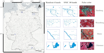
Large-scale mapping activities can benefit from the vastly increasing availability of earth observation (EO) data, especially when combined with volunteered geographical information (VGI) using machine learning (ML). High-resolution maps of inland surface water bodies are important for water supply and … Read More
Deutsch
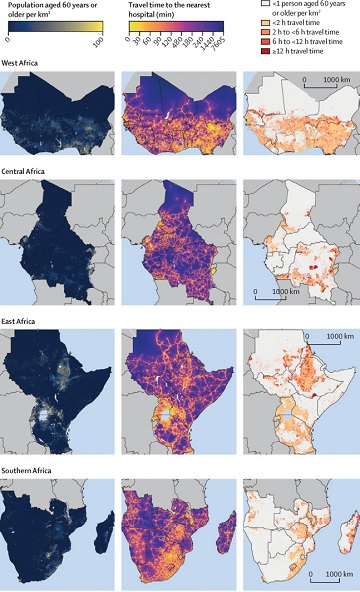
Mapping physical access to health care for older adults in sub-Saharan Africa and implications for the COVID-19 response: a cross-sectional analysis
New paper published on healthcare access in Sub-Saharan Africa It is almost a year since SARS-CoV-2 first emerged in China. The virus spread all over the world. Countries south of the Sahara did not receive much attention. Although outbreaks here … Read More
GIScience for physical activity research
GIScience methods are becoming more and more widespread in different domains. A current review article under involvement of HeiGIT researchers discusses the potential of ambulatory assessments and GIScience approaches for physical activity research. The article is on of the outcomes … Read More

Detecting OSM Building Facades with Graffiti Artwork Based on Street View Images and Social Media using Deep Learning
As a recognized type of art, graffiti is a cultural asset and an important aspect of a city’s aesthetics. As such, graffiti is associated with social and commercial vibrancy and is known to attract tourists. However, positional uncertainty and incompleteness … Read More