Welcome back to a new episode of how to become ohsome. Yes, you’ve read the heading correctly. We are really talking about a snake in a notebook on another planet. If you are familiar with one of the most used … Read More
Blog
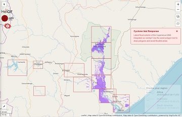
openrouteservice for Disaster Management: Response to Cyclone Idai
The Humanitarian OpenStreetMap Team (HOT) has launched an activation to support humanitarian operations responding to the impact of Cyclone Idai. These efforts were already supported by more than 1500 mappers of the global OpenStreetMap (OSM) community that contribute geodata about … Read More
HeiGIT supports Citizien Science @ Helmholtz ThinkCamp
We are always happy to support citizen science projects at the HeiGIT. HeiGIT/ GIScience efforts already range from tools that assess the data quality of citizen science projects (see, e.g., this blog post about “Plausible Parrots“) to approaches related to … Read More
Die Sendung mit der Maus: Zu Fuß durch Deutschland
Das HeiGIT unterstützt das Bundesamt für Kartographie und Geodäsie (BKG) dabei eine Frage aus der “Die Maus”-Redaktion zu beantworten: Welcher ist Deutschlands nördlichster & südlichster Ort, und wie groß ist die fußläufige Distanz dazwischen? Der Beitrag war am 23.03.2019 in … Read More
Preview: Spatial Joins using the OpenStreetMap History Database OSHDB
Max is two and loves spending Monday afternoons with his Dad at the playground. Finding a suitable playground however isn’t easy, since a few criteria must be met: there should be a bench and some trees nearby to get shelter … Read More
Jupyter Notebook: ohsome API
ohsome API: Data Aggregation Endpoint¶ Via the ohsome API you have access to the OSM history on a global scale :). Our documentation provides you with the needed information to fire some requests against the API. More infomation … Read More
openrouteservice Io is here!
openrouteservice Io is here! The openrouteservice from HeiGIT has just had its latest update, and we want to introduce you to Io (version 5.0). This new version brings something that has been a while in the making and will make … Read More
Global analyses are ohsome
We, the Big Spatial Data Analytics Group at HeiGIT have ohsome news to share: From now on, you can send your requests to our global ohsome API instance. So far, we’ve had a public instance for Nepal and Germany, but … Read More
Analysing semantic associations in VGI data
Volunteered Geographic Information (VGI) such as OpenStreetMap (OSM) can be a rich resource for many applications. Therefor VGI-projects have to mitigate between the requirements of the the volunteers and the machines. On the one hand, the data format should be … Read More
Empower Humanitarian Mapping with Deep Neural Networks to Detect Human Settlements
Recently, earth observation by satellites has shown great capability in supporting a range of challenges such as disaster assessment, agriculture monitoring, and humanitarian mapping. MapSwipe, as a humanitarian mapping app, provides a crowdsourcing platform to collect volunteered geographical information (VGI), … Read More
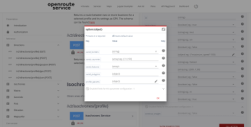
New features in OpenRouteService Interactive documentation
The ORS Playground is an interactive API documentation application that allows the users to explore and interact with all the API services. The elements, inputs and forms are built from a swagger documentation file. Since the first release of the … Read More
GIScience/HeiGIT and TdLab Geographie at german IPCC conference
GIScience will be present with two participants (Nicole Aeschbach, TdLab Geographie) and Sven Lautenbach (HeiGIT) at the german IPCC conference. Our contributions aim at highlighting the potential of GIScience and transdisciplinary research for climate change adaptation and climate change mitigation. … Read More
GIScience/HeiGIT at Global Land Project open science meeting
GIScience/HeiGIT member Sven Lautenbach is hosting together with Jonas Schwaab from the ETH Zürich a session on Multi-objective optimization approaches to support visioning and decision-making in land-use system science at the 4th Open Science Meeting of the Global Land Programme … Read More
Addressing the challenge of localizing SDGs with openrouteservice
Where is the next health center? What areas show less accessibility to health centers and are therefore the most vulnerable? In 2018, the openrouteservice team already illustrated how these questions related to vulnerability can be addressed with openrouteservice APIs, at … Read More
Hello world, openfuelservice!
In addition to our already exciting and fascinating portfolio of open source software we now offer openfuelservice which is a new and very experimental advance in the world of fuel consumption and emission of cars. In the recent political and … Read More
New OpenRouteService QGIS Plugin
Finally there is a new version of the QGIS plugin for OpenRouteService: ORS Tools. It gives easy access to our directions, isochrone and matrix API’s from within QGIS. The old plugin OSM Tools plugin has been deprecated due to its … Read More
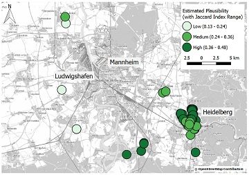
Plausible Parrots – HeiGIT’s OSHDB Supports Research in Citizen Science Data Quality
In the GIScience research group at Heidelberg University, a recent PhD research project by Clemens Jacobs has been looking into the data quality of citizen science observations of organisms. This research aims at using geographic context as an information source … Read More
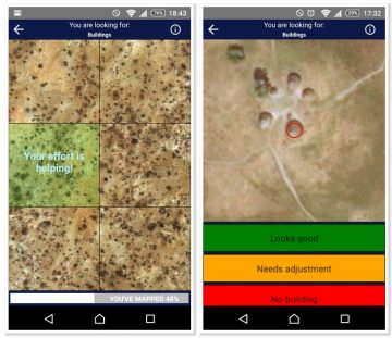
Put the world’s most vulnerable people on the map with MapSwipe
Humanitarian organizations can’t help people if they can’t find them. This was the simple reason to create MapSwipe back in 2016 and it is still as pressing as in the very beginning. In the last 2,5 years volunteers have contributed … Read More

HeiGIT and Humanitarian OpenStreetMap Team at the Geospatial World Forum 2019 in Amsterdam
Beginning of April, Amsterdam will become the gathering place for the global geospatial community. The Geospatial World Forum is organized for the 11th time and builds on previous successes that made it a leading event in sense of innovation, thematic … Read More
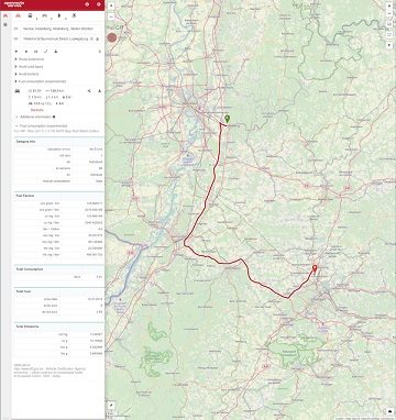
Using Openrouteservice in the data science platform alteryx
You can also use Openrouteservice via the self-service data analytics plattform alteryx, when you are a user of that data science product. Pablo Sáenz de Tejada (The Information Lab) has shared some macros on the alteryx public gallery using the … Read More