Hello and welcome back to the ohsome Region of the Month-blog post series where you can read about potential use cases of the ohsome API and maybe even get inspired to send some requests of your own. If you are … Read More
English

SWR broadcast on the research project HEAL: Taking the safe route through the heat – Transdisciplinary project HEAL makes everyday life easier for at-risk groups
Climate adaptation strategies to support and protect at-risk groups during hot weather periods are being developed as part of the transdisciplinary collaboration in the HEAL project by the research network consisting of the Heidelberg Institute for Geoinformation Technology (HeiGIT), the … Read More
A safe way through the heat: Transdisciplinary project HEAL makes everyday life easier for at-risk groups
As part of a transdisciplinary collaboration, the Heidelberg Institute for Geoinformation Technology (HeiGIT), the GIScience research group and the TdLab Geography at Heidelberg University are jointly developing adaptation strategies to support and protect at-risk groups during hot weather conditions. Individual … Read More
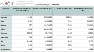
ohsome region of the month: Which country has the longest coastline?
The ohsome region of the month blog post series is back and since it’s summer this time we’re taking you to the coast. Before that happens, if this is your first blog post of this format you might want to … Read More
The ohsome quality analyst goes public on Github with new release 0.3.0
The ohsome quality analyst (short: OQT) has been introduced at the beginning of this year and today we are proud to announce two updates. First, we released the new version 0.3.0 which includes new OSM layers and a brand new … Read More
ohsomeHeX provides access to OSM feature history
Did you ever wonder how your city was mapped over time, how geometries were changed and refined, how mistakes were added and corrected again? Then read on: ohsomeHex has a great new feature for you – the individual object’s zoom-in-history-view. … Read More
Ohsome Region of the Month Building-Information Analysis
Welcome back to our blog post series ”ohsome Region of the Month” where you can find information on potential applications of the ohsome API. If you’re new to this format you can also read some of the former blog posts … Read More
MapAction and HeiGIT partner to further geoinformation innovation
The Heidelberg Institute for Geoinformation Technology (HeiGIT) and the international humanitarian geospatial charity MapAction have signed a Memorandum of Understanding (MoU) outlining their plans to collaborate in a number of areas. Both organisations share a common vision to support humanitarian … Read More
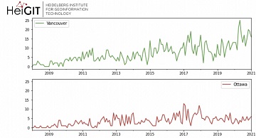
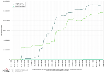
Ohsome Green Region of the Month
Welcome back to the ohsome region of the month format where you can learn and get inspiration about potential applications of the ohsome API. This time we looked at forest-related information in four different Canadian regions looking for the green … Read More
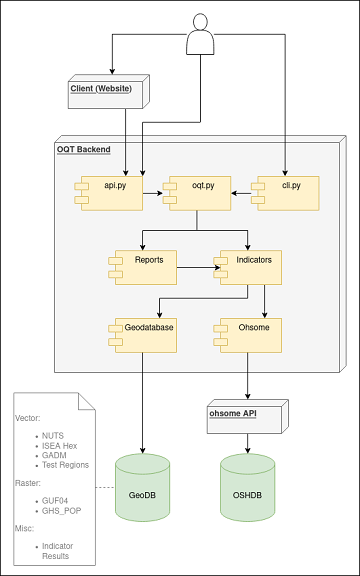
Behind the scenes of the ohsome quality analyst (OQT)
The #ohsome quality analyst (short: OQT) has been online and accessible through its web-interface now for quite some weeks already (see the introductory blog post as a reference). The website is not the only access point to the OQT though. … Read More
Open Position @ HeiGIT: Software Engineer OSM Routing Services – Backend & Algorithms
Sie lieben Open-Source-Geoinformationsdienste zu entwickeln, die täglich von Tausenden genutzt werden? Sie sind ein hochmotivierter Java Backend-Entwickler und Algorithmen-Designer? Und Sie wollen OpenStreetMap für leistungsstarke GI-Dienste mit globaler Abdeckung einsetzen und verbessern? Dann haben wir vielleicht einen passenden und interessanten … Read More
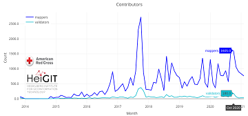
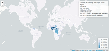
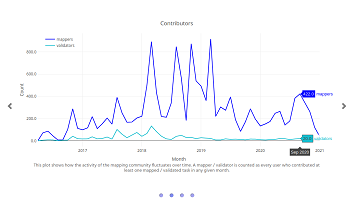
Humanitarian OSM Stats: How to monitor humanitarian mapping in the HOT Tasking Manager? – Part 5: the American Red Cross
Since 2010 organized humanitarian mapping has evolved as a constant and growing element of the global OpenStreetMap (OSM) community. With more than 8,000 projects in 150 countries humanitarian mapping has become a global community effort. Due to this large amount … Read More
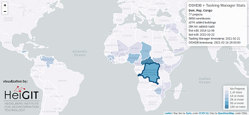
Humanitarian OSM Stats: How to monitor humanitarian mapping in the HOT Tasking Manager? – Part 4
Since 2010, organized humanitarian mapping has evolved as a constant and growing element of the global OpenStreetMap (OSM) community. With more than 7,000 projects in 150 countries, humanitarian mapping has become a global community effort. Due to this large amount … Read More
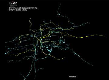
An ohsome Railway Network Visualization and Analysis
Welcome back to another #ohsome blog post written by our awesome student assistent Sarah! This time we will look at the completeness of railway network data of one specific city in OpenStreetMap, as well as its development. For this we … Read More
Humanitarian OSM Stats: How to monitor humanitarian mapping in the HOT Tasking Manager? – Part 3
Since 2010 organized humanitarian mapping has evolved as a constant and growing element of the global OpenStreetMap (OSM) community. With more than 7,000 projects in 150 countries humanitarian mapping has become a global community effort. Due to this large amount … Read More
Introducing the Ohsome Quality analysT (OQT)
The Ohsome Quality analysT (short OQT) is the name of a new software implemented by HeiGIT that is based on the #ohsome framework. Its main purpose is to compute quality estimations on OpenStreetMap (OSM) data. Any end user such as … Read More
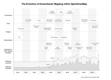
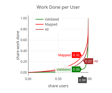
The evolution of humanitarian mapping within the OpenStreetMap community
In the past 10 years, the collaborative maps of OpenStreetMap (OSM) have been used to support humanitarian efforts around the world as well as to fill important data gaps for implementing major development frameworks such as the Sustainable Development Goals … Read More
Humanitarian OSM Stats: How to monitor humanitarian mapping in the HOT Tasking Manager? – Part 2
Since 2010 organized humanitarian mapping has evolved as a constant and growing element of the global OpenStreetMap (OSM) community. With more than 7,000 projects in 150 countries humanitarian mapping has become a global community effort. Due to this large amount … Read More
ohsome street network analysis part 2
Welcome to part 2 of the #ohsome street network analysis. If you haven’t read the first part yet, you can do so following this link. As promised, this week we are performing a simple tag completeness analysis, where we are … Read More
Humanitarian OSM Stats: How to monitor humanitarian mapping in the HOT Tasking Manager? – Part 1
Since 2010 organized humanitarian mapping has evolved as a constant and growing element of the global OpenStreetMap (OSM) community. With more than 7,000 projects in 150 countries humanitarian mapping has become a global community effort. Due to this large amount … Read More